#475 closed bug (fixed)
square raster's pixels not square on display = rasters of different res are displaced
| Reported by: | Owned by: | nobody | |
|---|---|---|---|
| Priority: | major: does not work as expected | Milestone: | |
| Component: | Rasters | Version: | Trunk |
| Keywords: | Cc: | ||
| Must Fix for Release: | Yes | Platform: | Debian |
| Platform Version: | Ubuntu Dapper | Awaiting user input: | no |
Description
- add a a raster with *square* pixels
- change QGIS window's proportion to be taller-than-wide, or vice versa
- zoom in
- see how the pixels are not displayed square (too_wide.png, too_narrow.png)
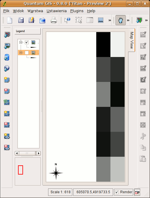
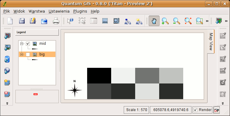
- now display one raster of 5m and one of 10m resolution
- see how they are misplaced against each other; set some transparance to see this clearly (misplaced.png)
BTW, these are GRASS rasters I used for examples here, created with r.mapcalc. In QGIS the r.mapcalc output is displayed B&W, while in GRASS (see GRASS_mon.png) it is color with "rainbow" pallete. Note that after I run 'r.colors rules=rainbow' for the raster displayed B&W in QGIS and color in GRASS, it is displayed color in both from then on... weird. Ideas where is the bug (GRASS, GDAL, QGIS, gdal-grass)?
Maciek
Attachments (6)
Change History (18)
by , 18 years ago
| Attachment: | too_tall.png added |
|---|
by , 18 years ago
| Attachment: | too_wide.png added |
|---|
by , 18 years ago
| Attachment: | displaced.png added |
|---|
by , 18 years ago
| Attachment: | GRASS_mon.png added |
|---|
follow-up: 3 comment:1 by , 18 years ago
follow-up: 4 comment:2 by , 18 years ago
I can't duplicate the problem described in steps 1-4, using either a TIFF or GRASS raster.
GDAL 1.3.2, GRASS 6.2.0
comment:3 by , 18 years ago
comment:4 by , 18 years ago
Replying to gsherman:
I can't duplicate the problem described in steps 1-4, using either a TIFF or GRASS raster.
And I can reproduce it with any raster. Why you can't I don't know.
Pan to the edge of your raster, maybe then you'll see it better. If you still can't see it, measure the pixel dimensions; one axis will be longer (while both should be equal).
GDAL 1.3.2
Same here.
GRASS 6.2.0
I don't think this matters. The bug is in displaying all rasters.
Maciek
follow-up: 6 comment:5 by , 18 years ago
I don't need to measure the pixels. I can see that they are still square and I did try it from various locations in the raster.
follow-up: 7 comment:6 by , 18 years ago
Well then can you display 2 rasters with identical cells allignment, but of different resolution, set the transparency, and reproduce steps 5, 6?
follow-up: 8 comment:7 by , 18 years ago
Replying to tutey@o2.pl:
Well then can you display 2 rasters with identical cells allignment, but of different resolution, set the transparency, and reproduce steps 5, 6?
I don't have any suitable test data....
comment:8 by , 18 years ago
Replying to gsherman:
I don't have any suitable test data....
Attached are 2 such rasters. One is 5m, the other is 10m. Both have exactly the same extent. Open them in QGIS and set transparency for both. Zoom and pan around a bit. Let me know if you can see how missalligned they are against each other. I can. The missalignment is different depending on zoom level and view center point location. It dissapears after zooming to either rasters full extent.
Maciek
by , 18 years ago
by , 18 years ago
comment:9 by , 18 years ago
This problem can be seen in another way that doesn't require two images.
- load the 5res.tif image
- click on the zoom in tool to get a cross-hair cursor
- place the cursor over the bottom right corner of the image and note down the x/y coordinates (should be 481510, 4180530)
- pan the image so that the bottom right corner of the image is in the middle of the map
- click on the zoom in tool to get a cross-hair cursor again
- place the cursor over the same corner and note the x/y coords. They are different. This is the underlying cause of the mis-matched images.
The x/y coordinate of that corner varies with panning and zooming of the image.
comment:10 by , 18 years ago
Further note: this problem only occurs when the image is panned so that some of the image is off the visible map.
comment:11 by , 18 years ago
| Resolution: | → fixed |
|---|---|
| Status: | new → closed |
Does the problem correct itself after the next pan / zoom?