Opened 14 years ago
Last modified 13 years ago
#3155 assigned bug
Zoom to layer works incorrectly while layer editing
| Reported by: | dr | Owned by: | sunilkcube |
|---|---|---|---|
| Priority: | major: does not work as expected | Milestone: | Version 1.7.0 |
| Component: | MapCanvas | Version: | Trunk |
| Keywords: | Cc: | dr, gislab, alexbruy | |
| Must Fix for Release: | Yes | Platform: | All |
| Platform Version: | Awaiting user input: | no |
Description
- Open raster layer (http://gis-lab.info/share/DR/modis.7z);
- Add new polygonal vector layer;
- Draw little polygon in right top corner of raster;
- Stop editing and save changes;
- Make with zoom out tool raster layer looks like small rectangle in center of View;
- Toggle editing and draw new polygon in right top corner of view;
- Without stopping editing try make zoom to layer on vector layer;
- Looks like extent calculates incorrect.
- Stop editing, don't save changes and try zoom to vector layer again. Zoom to layer work incorrectly.
Attachments (1)
Change History (7)
comment:1 by , 14 years ago
comment:2 by , 14 years ago
| Owner: | changed from to |
|---|---|
| Status: | new → assigned |
comment:3 by , 13 years ago
Recalculating the extent on every editing operation could be quite expensive. So it might be useful to make this optional and disable "zoom to layer" while editing. There's also the issue of undo/redo.
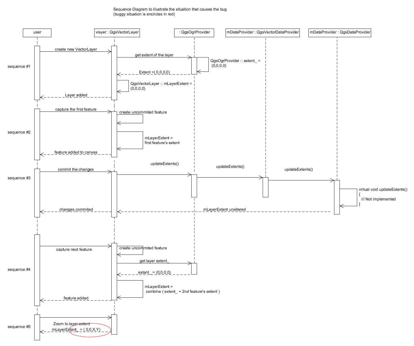
by , 13 years ago
| Attachment: | seq -diagram.jpg added |
|---|
Sequence Diagram to illustrate the bug situation
follow-up: 5 comment:4 by , 13 years ago
What about recalculating the extent when the "zoom to layer" pressed (only if the layer is dirty).
follow-up: 6 comment:5 by , 13 years ago
Replying to borysiasty:
What about recalculating the extent when the "zoom to layer" pressed (only if the layer is dirty).
The comment from Jef tells that calculating extents while editing is quite expensive.
comment:6 by , 13 years ago
Replying to sunilkcube:
The comment from Jef tells that calculating extents while editing is quite expensive.
Not exactly, the comment from Jef is about recalculating on every operation.
5-7. I confirm, the extent looks wrong. http://gis-lab.info/images/screenshots/20101028-69a-65kb.jpg
http://gis-lab.info/images/screenshots/20101028-19d-62kb.jpg