Opened 15 years ago
Last modified 14 years ago
#1969 new bug
Measure tools and scale give wrong readings with OTFR disabled
| Reported by: | vince | Owned by: | homann |
|---|---|---|---|
| Priority: | major: does not work as expected | Milestone: | Version 1.7.0 |
| Component: | Projection Support | Version: | Trunk |
| Keywords: | area tool measure | Cc: | |
| Must Fix for Release: | No | Platform: | All |
| Platform Version: | Awaiting user input: | no |
Description
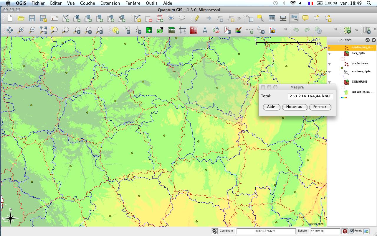
In 1.3.0, the area measurement tool sometimes goes daft. Proof on the attached screenshot.
Attachments (1)
Change History (13)
by , 15 years ago
| Attachment: | Capture d’écran 2009-10-02 à 18.49.40.jpg added |
|---|
comment:1 by , 15 years ago
| Component: | Build/Install → Vectors |
|---|
comment:2 by , 15 years ago
| Priority: | critical: causes crash or data corruption → major: does not work as expected |
|---|
comment:3 by , 15 years ago
Not replicable here. Can you check in which condition does this happen? Only with particular data or projections maybe? If so, sample data would be useful to attach to the ticket
follow-up: 6 comment:4 by , 15 years ago
You're right, it does only happen for a single layer and a single projection. Bad luck, the layer is not free so I cannot post it here (it is anyhow too big: 36000 polygons representing France 36000 cities). Bad luck again, I tried to clip the layer, but the resulting intersection does not present the same symptom. I'll try to dig a bit further.
comment:5 by , 15 years ago
I found a way to easy replicate the behaviour. I guess.
Open a new project, in my case by default it opens in wgs84, then add the "alaska" (epsg 2964, projected CRS) shapefile from the qgis sample dataset. With OTFR not enabled, the measure area results are wrong.
Enable OTFR and you'll see now that the tool give right results. Disable OTFR and again is all ok.
follow-up: 7 comment:6 by , 15 years ago
| Milestone: | → Version 1.4.0 |
|---|
Replying to vince:
You're right, it does only happen for a single layer and a single projection. Bad luck, the layer is not free so I cannot post it here (it is anyhow too big: 36000 polygons representing France 36000 cities). Bad luck again, I tried to clip the layer, but the resulting intersection does not present the same symptom. I'll try to dig a bit further.
Hi,
did you made any further test?
Can you relate your problem with the behaviour I described?
comment:7 by , 15 years ago
Replying to lutra:
Hi, did you made any further test? Can you relate your problem with the behaviour I described?
Oops sorry. I'll try, but meanwhile I stumbled on another bug I'm a bit investigating. I'll be back tomorrow on this one :)
follow-up: 9 comment:8 by , 15 years ago
The bug affects the linear ruler too. It seems to be triggered by the 'on the fly' projection conversion option.
comment:9 by , 15 years ago
| Component: | Vectors → Projection Support |
|---|---|
| Owner: | changed from to |
| Platform: | OS X → All |
Replying to vince:
The bug affects the linear ruler too. It seems to be triggered by the 'on the fly' projection conversion option.
can you be more specific (maybe posting a sample of your data)?
This is my observation:
- open a new project and check in the options that the "preferred measurement unit" is meters and that otfr is disabled
- add a layer with a projected CRS: if the "layer unit" option (in the "general" tab of the "project properties" menu) is defined accordingly with the layer CRS unit, then all "measure area", "measure line" and scalebar do give *right values*
- if by mistake you have a layer with a CRS unit defined in meters BUT the "layer unit" defined in feet or degrees, you'll read wrong values despite having "preferred measurement unit" in meters.
Lewt me know if this make sense to you.
comment:10 by , 14 years ago
| Platform Version: | 10.6 (Snow Leopard) |
|---|---|
| Summary: | Area tool goes amok → Measure tools and scale give wrong readings with OTFR disabled |
| Version: | 1.3.0 → HEAD |
I believe this is really the behaviour of qgis right now: if otfr is not enabled then layer units must be defined accordingly to crs units (in project properties), otherwise the scalebar will be wrong and measure tools will work accordingly with the bar.
With otfr enabled things seems really to work as expected.
comment:11 by , 14 years ago
I confirm the observations by lutra, on current trunk (1.5). While understandable, the behaviour is incorrect, and should be fixed.
comment:12 by , 14 years ago
| Milestone: | Version 1.5.0 → Version 1.6.0 |
|---|
Screen shot (observe area measure and scale bar above)