Opened 15 years ago
Closed 15 years ago
#1865 closed bug (fixed)
ftools "Union" gives wrong results with non overlapping polygons
| Reported by: | lutra | Owned by: | cfarmer |
|---|---|---|---|
| Priority: | critical: causes crash or data corruption | Milestone: | Version 1.2.0 |
| Component: | Python plugins and bindings | Version: | Trunk |
| Keywords: | geoprocessing, overlay, union, non-overlapping | Cc: | |
| Must Fix for Release: | No | Platform: | All |
| Platform Version: | Awaiting user input: | no |
Description
I'm not sure to classify this as "critical" but as the resulting attribute tables are wrong seems to me "data corruption". If I'm wrong please change the priority of the ticket.
I noticed that applying the ftools "Union" tool to non overlapping polygons (if the polygons do overlap then results are ok) returns *always* a wrong attribute table.
The "old" geoprocessing tool plugin gives better results, as it does GRASS v.overlay.or
I was playing around with different polygon layers with different table of attributes (that for the "Union" operation does not make a lot of difference), so I also noticed that in the same case (non overlapping polygons) when the two attribute tables have different column names but same types then both the "old" geoprocessing tool plugin and GRASS v.overlay.or do an error.
I compared with the results given by the Union tool of Arcgis 9.x and gvSIG and in this case the results are ok with both software, so if ftools is going to be fixed then would be better to avoid the error made by the other two qgis solutions.
See attached files.
Attachments (2)
Change History (5)
by , 15 years ago
| Attachment: | union_non_overlapping.zip added |
|---|
follow-up: 2 comment:1 by , 15 years ago
| Resolution: | → fixed |
|---|---|
| Status: | new → closed |
follow-up: 3 comment:2 by , 15 years ago
| Resolution: | fixed |
|---|---|
| Status: | closed → reopened |
Replying to cfarmer:
This has been fixed in r11341. Note: Results should coincide with those from ArcGIS and gvSIG.
- Carson
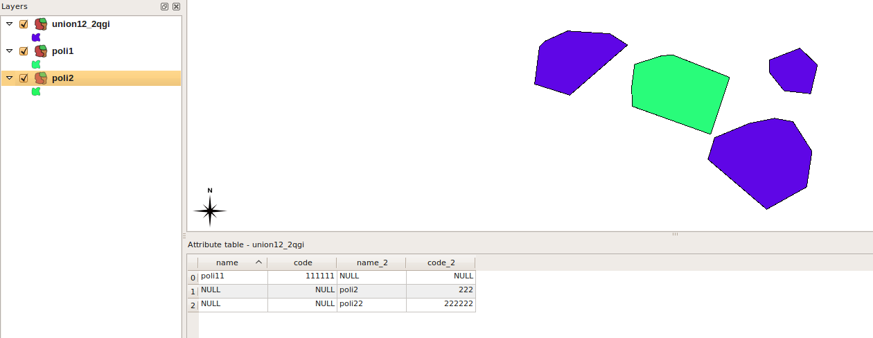
Hi Carson, thanks for the effort.
I gave it a look and it seems to have yet a problem when using Union with two layers with identical attribute tables. What seems to do is to "delete" the first feature of the first layer used. See attached image.
by , 15 years ago
| Attachment: | Screenshot.png added |
|---|
comment:3 by , 15 years ago
| Resolution: | → fixed |
|---|---|
| Status: | reopened → closed |
Replying to lutra:
I gave it a look and it seems to have yet a problem when using Union with two layers with identical attribute tables. What seems to do is to "delete" the first feature of the first layer used. See attached image.
This should be fixed in r11347. There was a problem when the bounding boxes of features intersected, but their geometries did not. Please test with your previous dataset to ensure this has been fixed properly...
-Carson
This has been fixed in r11341. Note: Results should coincide with those from ArcGIS and gvSIG.