Opened 15 years ago
Closed 15 years ago
#1687 closed bug (fixed)
Measure tool is very wrong
| Reported by: | kwilliams4 | Owned by: | nobody |
|---|---|---|---|
| Priority: | major: does not work as expected | Milestone: | |
| Component: | Build/Install | Version: | 1.0.0 |
| Keywords: | Cc: | ||
| Must Fix for Release: | No | Platform: | Debian |
| Platform Version: | Awaiting user input: | no |
Description
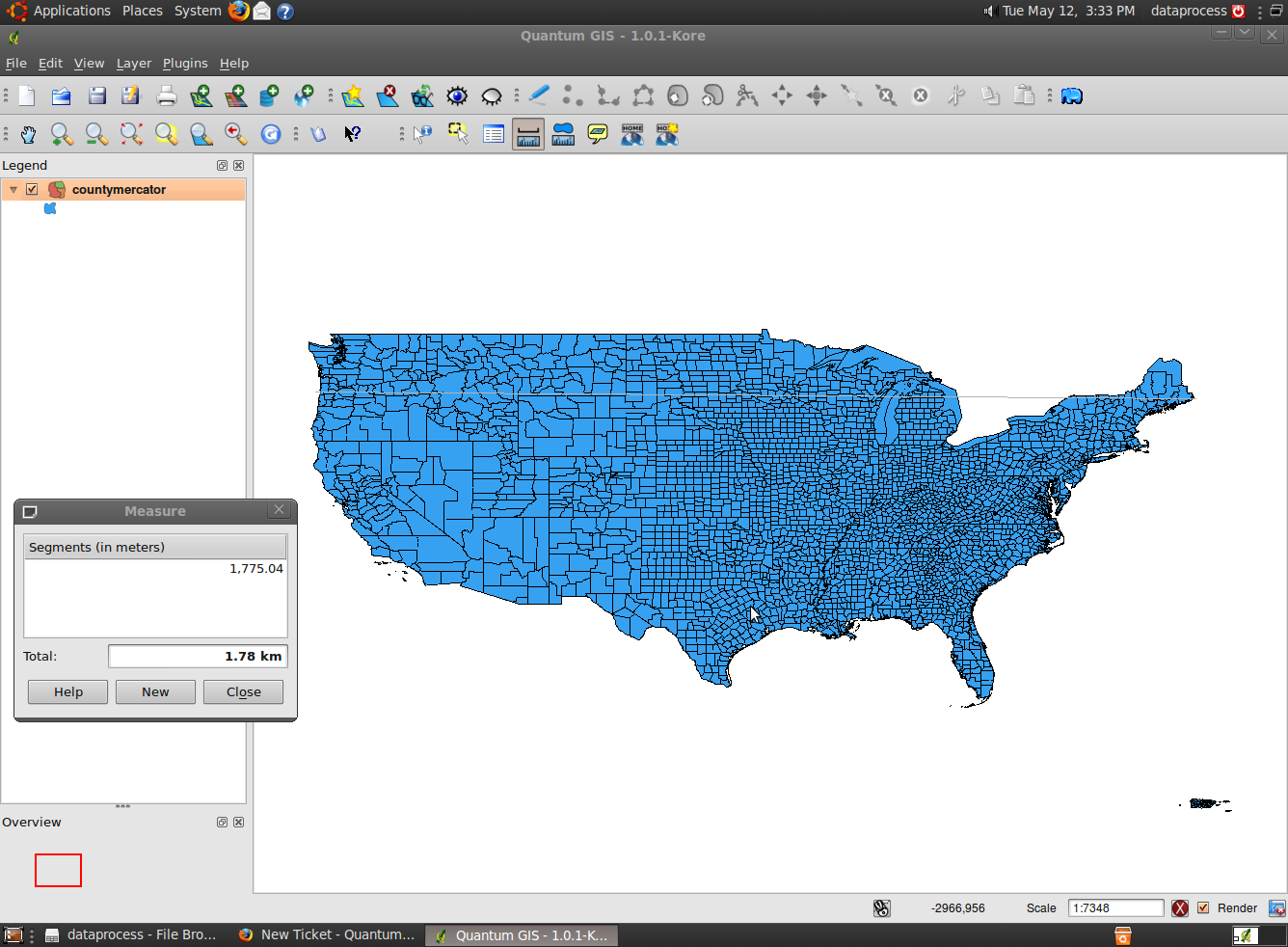
I have a shapefile that has a projection of World Mercator (EPSG:54004).
My view is set with the same coordinate system. My measurement units are set at meters. (Both of which should hopefully be set automatically, but neither are when adding the data to a new map.)
When I measure across the width of the continent of the united states, I get a distance of about 1.8 kilometers! That is obviously incredibly wrong! As currently implemented, the measure tool is completely useless. This isn't just a metric versus imperial issue. It's 100% completely off. For QGIS to be considered even a decent viewer for GIS data the measure tool at least ought to work as it says it should.
I'm using Ubuntu 9.04 with QGIS 1.0.1 installed from the proper repository.
Attachments (1)
Change History (3)
by , 15 years ago
| Attachment: | Screenshot.png added |
|---|
comment:1 by , 15 years ago
Please double check that your layer projection definition is correctly. Using EPSG: 3395 which is an identical proj string (as far as I can see) to 54004 it works fine.
The coordinates in your screenshot do not correspond to the correct location of any part of the US in the projection you specified.
comment:2 by , 15 years ago
| Resolution: | → fixed |
|---|---|
| Status: | new → closed |
It appears that the Ubuntu repository ogr2ogr was not projecting the data properly (didn't read the source projection correctly) ruining the coordinates and not transforming the geometry.
After discovering the projection problem, the measurement does indeed work properly, although I wish it compensated distance measurements for latitude like uDig does with this projection. As-is, the measure tool now gives identical results to ArcMap - no corrections applied on projected coordinate systems.
Thanks for the quick response. I guess I should've noticed that bad projection immediately in hindsight.
Screen capture showing the error