Opened 13 years ago
Closed 13 years ago
#1338 closed task (fixed)
[raster] document ST_PixelWidth and ST_PixelHeight
| Reported by: | dzwarg | Owned by: | dzwarg |
|---|---|---|---|
| Priority: | medium | Milestone: | PostGIS 2.0.0 |
| Component: | documentation | Version: | master |
| Keywords: | Cc: |
Description 
These are in trunk, need documentation.
Change History (5)
comment:1 by , 13 years ago
by , 13 years ago
by , 13 years ago
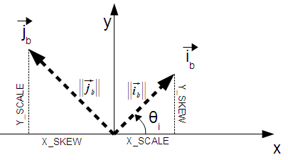
| Attachment: | ReverseTransform.odg added |
|---|
Source of the illustration (openoffice drawing document)
comment:2 by , 13 years ago
done at r8301 and I incorporated the image in ST_PixelWidth.
Ideally we should have a chapter on raster fundamentals and best practices that covers these things in more detail and that is linked back to from the reference functions.
Something similar to http://www.postgis.org/documentation/manual-svn/using_postgis_dbmanagement.html (primary importance)
and - http://www.postgis.org/documentation/manual-svn/ch05.html (secondary).
Where we would stuff raster concepts / best practices etc. I was thinking about putting it in those existing sections, but I think that may just confuse people not using raster and force people looking for raster information to sift through stuff that is only useful if you are doing strictly geometry. Raster is dfferent enough that it deserves its own chapters and we rename the existing Data Management for Geometry/Geography etc. Granted there is some overlap, but that overlap is probably better served in a raster section with reference to it from the geometry section.
comment:3 by , 13 years ago
| Component: | postgis raster → documentation |
|---|---|
| Resolution: | → fixed |
| Status: | new → closed |
feel free to reopen if you think further changes are required
It would be very helpful to include a figure.
Depending on how in depth you want to go, there are images of typeset equations (justifying this picture) on DevWikiRealParameters.
Note that the terms "width" and "height" may or may not be clear. After all, rotate 90 degrees (perfectly legal) and "width" becomes "height".