
Opened 15 years ago
Last modified 14 years ago
#2965 assigned defect
Umlaut with VirtualSpatialData
| Reported by: | MatthiasHeber | Owned by: | warmerdam |
|---|---|---|---|
| Priority: | normal | Milestone: | 6.0 release |
| Component: | OGR Support | Version: | unspecified |
| Severity: | normal | Keywords: | ovf umlaute |
| Cc: | warmerdam, chaitanya, dmorissette, aboudreault |
Description (last modified by )
Moin, in MapServer 5.0.0 the ovf-file works well with Umlaute (e.g. ü, ä, ...). In MS 5.2.x the VirtualSpatialData connection supplies no result if there are Umlaute.
Matthias
Attachments (5)
Change History (12)
by , 15 years ago
comment:1 by , 15 years ago
| Cc: | added |
|---|---|
| Milestone: | → 6.0 release |
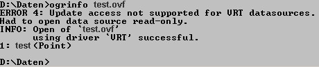
I don't see the umlautes in the ovf.jpg attachment. Are they in the OVF file or in the actual attribute values? Can you please test with "OGRINFO" at the command-line on that OVF file and see if it has the same problem?
Also, on which OS are you running and which version of GDAL/OGR are you using in both cases? If you use MS4W then what are the two MS4W versions that you were using/comparing?
comment:2 by , 15 years ago
Oh, sorry. I had described it imprecise. The umlautes are in the attributes of the database. The ogrinfo is in the attachment (ogrinfo.jpg).
I'm using a Laptop with Windows XP-64bit, SP 2; Microsoft SQL-Server 2005 SP 3; 32-bit-ODBC-driver is SQLSRV32.dll, Version 200.86.3959.00.
The working ms4w-version is ms4w-2.2.6 (php 5.2.4, Mapserver 5.0.0 and Mapscript, Revision 6872). The malfunctioned version is ms4w-2.3.1.
Possibly interesting is that we use NVARCHAR respectively NCHAR-datatypes (unicode UCS-2 LE).
comment:3 by , 15 years ago
| Cc: | added |
|---|---|
| Description: | modified (diff) |
Hi,
Could you please use the command "ogrinfo test.ovr test" so that ogrinfo actually reports on the features of the test layer? We are wanting to check if ogrinfo reports the umlautes properly (in which case this is a mapserver problem) or if the problem is with OGR itself. It would also be helpful to confirm the GDAL/OGR version, which you can do with the command "ogrinfo --version".
There were significant changes in GDAL 1.6.0 with regard to the ODBC driver and NVARCHAR fields - to ensure that they are captures as UTF-8. If the problem turns out to be with the ODBC driver we will need more details on how to create an ODBC datasource which demonstrates this problem.
Adding Chaitanya as a cc: as I'll likely ask him to review the problem if it turns out to be OGR's ODBC driver.
comment:4 by , 15 years ago
The "ogrinfo test.ovf test" delivers in the old version (no information with "ogrinfo --version" but it's the standard ms4w-2.2.6) the correct umlautes. In the new version ("GDAL 1.6.0, released 2008/11/26") the umlautes are corrupt.
comment:5 by , 15 years ago
Matthias,
I still need the detailed ogrinfo with feature information (in particular a feature that should have an umlaute. I'll also need details on the database being used, definition of the table, etc. Enough information that I can reproduce the problem.
by , 15 years ago
| Attachment: | dbo.PR_GEOTH_TOOLTIP.SQL added |
|---|
insert script (consider file encoding)
comment:6 by , 14 years ago
| Cc: | added |
|---|---|
| Owner: | changed from to |
Sounds like a OGR issue, and unfortunately I'm not setup to test with SQL Server. Are you able to reproduce at your end Frank?
comment:7 by , 14 years ago
| Status: | new → assigned |
|---|
I do not believe I have sql server installed, though I might be able to do so if needed. Chaitanya, do you have it installed already? If so, please attempt to reproduce this problem (at least through OGR/ogrinfo without MapServer) and report what you find. If not, let me know and perhaps I'll install it in the next day or two.
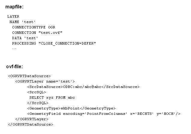
extract of mapfile and ovf-file