
Opened 15 years ago
Closed 14 years ago
#1068 closed defect (fixed)
Gaps in reprojected raster
| Reported by: | beginbenoit | Owned by: | |
|---|---|---|---|
| Priority: | medium | Milestone: | 2.2 |
| Component: | Rendering Service | Version: | 2.1.0 |
| Severity: | major | Keywords: | raster, reprojection, rendering |
| Cc: | External ID: | 1306134 |
Description
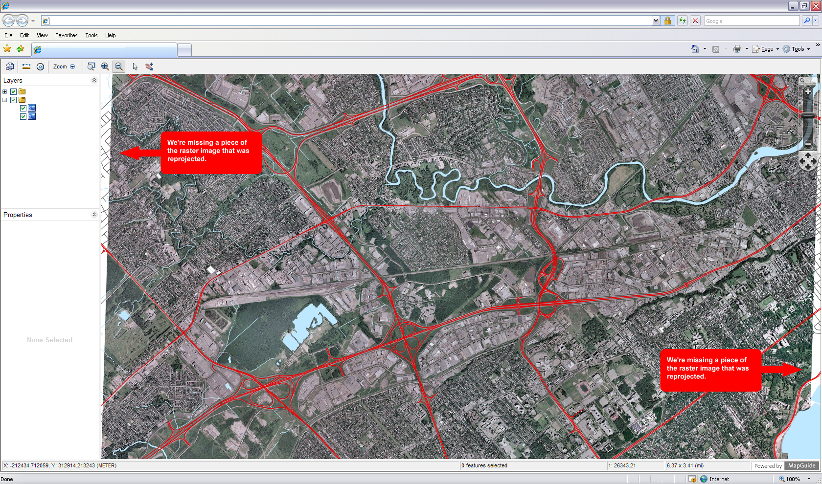
When raster images are reprojected, it seems to leave gaps depending on the type of reprojection being done. My map is in CANQ-LCC-83 (Quebec; Lambert Conformal Conic projection, NAD 83 datum). The attached screenshot shows an ECW composite layer in a CANQ-M7 (NAD83 Zone 7, Metre; Quebec 72 to 69 deg West). I have also attached the config XML of the raster FeatureSource to give further details.
What I think happens is that Mapguide retrieves the extent it needs for the raster, then reprojects the raster image afterwards. Depending on the transformation, this leaves some gaps on the sides as the reprojection skews the raster smaller than the actual extent that is being seen by the user.
I had to blur out some things in the screenshot and change some path due to the confidential nature of some of the information, but from a technical standpoint everything is the same.
Attachments (2)
Change History (7)
by , 15 years ago
| Attachment: | RasteReprojection.jpg added |
|---|
by , 15 years ago
| Attachment: | RasteReprojectionFeatureSource.xml added |
|---|
comment:1 by , 15 years ago
Could you attach a MapGuide package that we can load to reproduce the problem? I think that for this we could get away with using a raster image that is fabricated and all a single color with grid lines on it (so that we can see that reprojection is happening). Thanks, Tom
comment:2 by , 15 years ago
Our package is kind of large (140mb), so I made it available at the following URL: http://support.geomapgis.ca/webdownloads/OSGEO/RasterProjSample.zip
The imagery is setup to be in c:\sample\
Sorry it took so long to get it available, we had to do some manipulation to the data to only get a very very tiny subset of it.
comment:3 by , 15 years ago
Thanks. The zip file allowed me to reproduce the problem. It was reproducible with the Autodesk Raster provider so the problem is most likely with the reprojection algorithm not extracting enough of the source image. Now we just need to find someone with time to fix it :(.
comment:4 by , 14 years ago
| External ID: | → 1306134 |
|---|
comment:5 by , 14 years ago
| Milestone: | → 2.2 |
|---|---|
| Resolution: | → fixed |
| Status: | new → closed |
Fixed by r4736
Example of the graphical result