Opened 13 years ago
Last modified 13 years ago
#3632 closed bug
incorrect reprojection on windows (7), fine on linux — at Initial Version
| Reported by: | nirvn | Owned by: | nobody |
|---|---|---|---|
| Priority: | critical: causes crash or data corruption | Milestone: | Version 1.7.0 |
| Component: | Projection Support | Version: | Trunk |
| Keywords: | Cc: | ||
| Must Fix for Release: | Yes | Platform: | Windows |
| Platform Version: | Awaiting user input: | no |
Description
There's an on the fly reprojection issue going on with QGIS on windows platform (working fine under linux, untested on mac).
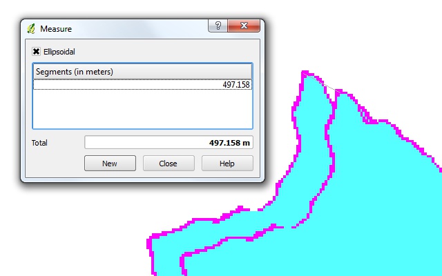
On the windows version of QGIS, a WGS84 datum layer and its Indian 1960 48N datum equivalent fails to project on top of each other, ending up in a +450 meter (!) difference in location. (see screenshot attached)
I've been noticing this for quite some time but didn't find a good way to explain the issue until now.
Steps to reveal issue: 1/ Create a new program, set the CRS to UTM Indian 1960 48N and activate on the fly reprojection. 2/ Load the raster @ http://licadho-cambodia.org/qgis/ASTGTM_N11E103.zip (it's a simple aster gdem geotiff) into the project 3/ Using the gdal's wrap tool, transform the astgm_n11e103_dem.tiff's WGS84 datum to Indian 1960 48N datum 4/ Load the generated raster 5/ Apply the this colormap (http://licadho-cambodia.org/qgis/bugramp.txt) to both rasters to make it easier to observe the issue
Et voila.
Loading the two rasters into the linux version of QGIS will render just fine.
Change History (1)
by , 13 years ago
| Attachment: | ontheflyreprojection-wsg84-vs-indian1960_48n.jpg added |
|---|