| Version 20 (modified by , 12 years ago) ( diff ) |
|---|
An example showing how to simplify a multipolygon layer, keeping topology between objects
Note: another method to generalize objects using Postgis Topology is described here: UsersWikiSimplifyWithTopologyExt
Table of Contents
What we want
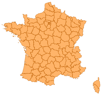
| Simplifying this layer: | into this: | avoiding that: |
 |  | 
|
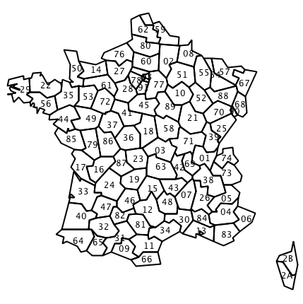
The data
French administrative subdivisions, called "départements", will be used. Data can be downloaded here: http://professionnels.ign.fr/DISPLAY/000/528/175/5281750/GEOFLADept_FR_Corse_AV_L93.zip
Data projection is Lambert-93, EPSG:2154
Loading the data
shp2pgsql -IiD -g geom -s 2154 DEPARTEMENT.SHP departement | psql
Principle of simplification
Based on the technique described here http://gis.stackexchange.com/questions/178/simplifying-adjacent-polygons:
- we extract linestrings out of polygons,
- then union and simplify them
- st_polygonize() is used to rebuild surfaces from linestrings.
- Finally, attributes from the initial layer are associated with simplified polygons.
Steps
Steps are divided into individual queries for the sake of clarity. One big query summarize them at the end of this page
- First extract the input multipolygons into polygons, keeping their departement code. This will allow us to associate attributes to each part of multipolygons at the end of the process.
create table poly as (
    select gid, code_dept, (st_dump(geom)).*
    from departement
);
- extract rings out of polygons
create table rings as (
    select st_exteriorRing((st_dumpRings(geom)).geom) as g
    from poly
);
- Simplify the rings. At this step, we choose the simplification ratio we want (some trials can be made by calling st_simplifyPreserveTopology on departement table).
Here, no points further than 10km:
create table simplerings as (
    select st_simplifyPreserveTopology(st_linemerge(st_union(g)), 10000) as g
    from rings
);
- extract lines as individual objects, in order to rebuild polygons from these simplified lines
create table simplelines as (
    select (st_dump(g)).geom as g
    from simplerings
);
5.rebuild the polygons, first by polygonizing the lines, with a distinct clause to eliminate overlaping segments that may prevent polygon to be created, then dump the collection of polygons into individual parts, in order to rebuild our layer.
create table simplepolys as (
    select (st_dump(st_polygonize(distinct g))).geom as g
    from simplelines
);
- Add an id column to help us identify objects and a spatial index
alter table simplepolys  add column gid serial primary key;
create index simplepolys_geom_gist on simplepolys  using gist(g);
- attribute association between input layer and simplified polygons: First method to retrieve attribute is based on containment of a point of the surface of simplified polygons.
create table simpledep as (
    select code_dept, g
    from departement d, simplepolys s
    where st_contains(d.geom, st_pointOnSurface(s.g))
);
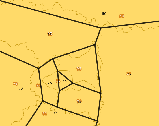
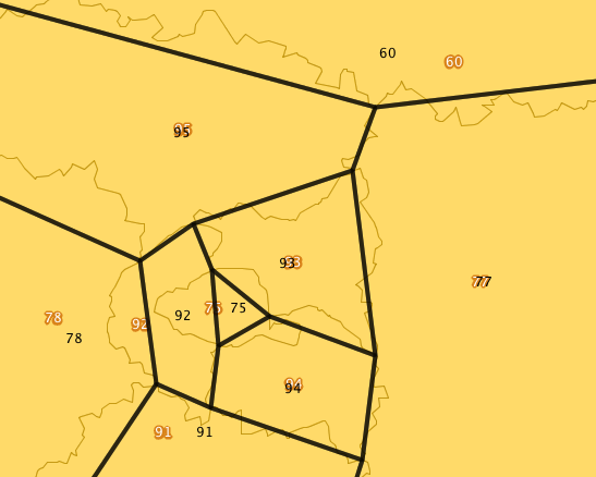
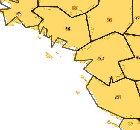
It does not work: code_dept=92 is a curved polygon and fails with st_contains() test:

- Second method is based on percentage of overlaping area comparison. Empirical ratio used here.
create table simpledep as (
        select d.code_dept, s.g as geom
        from departement d, simplepolys s
        where st_intersects(d.geom, s.g)
        and st_area(st_intersection(s.g, d.geom))/st_area(s.g) > 0.5
);
It gives better results in our testcase:

- rebuild departements by grouping them by code_dept (other attributes could be re-associated here):
create table simple_departement as (
        select code_dept, st_collect(geom) as geom
        from simpledep
        group by code_dept
);
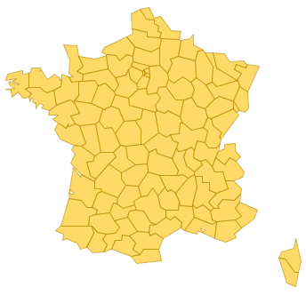
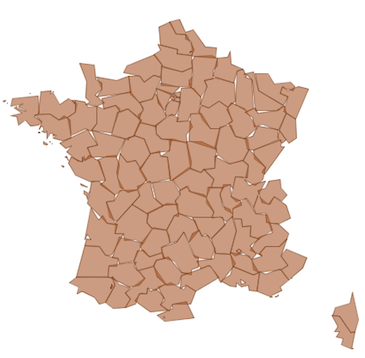
Result
Layer now looks like this:

Small island where collapsed during process:

One big query
with poly as (
        select gid, code_dept, (st_dump(geom)).*
        from departement
) select d.code_dept, baz.geom
 from (
        select (st_dump(st_polygonize(distinct geom))).geom as geom
        from (
                select (st_dump(st_simplifyPreserveTopology(st_linemerge(st_union(geom)), 10000))).geom as geom
                from (
                        select st_exteriorRing((st_dumpRings(geom)).geom) as geom
                        from poly
                ) as foo
        ) as bar
) as baz,
poly d
where st_intersects(d.geom, baz.geom)
and st_area(st_intersection(d.g, baz.geom))/st_area(baz.g) > 0.5;
Function wrapper
The following code could be wrapped into a function like this. (It uses unlogged and temp tables, but not sure if it really helps to get speed):
-- takes a table name, gid and geom column and simplify the layer based on given tolerance.
-- returns a setof (gid int, geom geometry). where geom is the simplified geometry and gid is the tablename gid.
create or replace function simplifyLayerPreserveTopology (tablename text, id_col text, geom_col text, tolerance float) returns setof record as $$
    DECLARE
        tabname alias for $1;
        tid alias for $2;
        geo alias for $3;
        tol alias for $4;
        numpoints int:=0;
        time text:='';

    BEGIN

        EXECUTE 'select sum(st_npoints(geom)), to_char(clock_timestamp(), ''MI:ss:MS'') from '||quote_ident(tabname) into numpoints, time;
        raise notice 'Num points in %: %. Time: %', tabname, numpoints, time;

        EXECUTE 'create unlogged table poly as ('
                ||'select '||quote_ident(tid)||', (st_dump('||quote_ident(geo)||')).* from '||quote_ident(tabname)||')';

        -- extract rings out of polygons
        create unlogged table rings as
        select st_exteriorRing((st_dumpRings(geom)).geom) as g from poly;

        select to_char(clock_timestamp(), 'MI:ss:MS') into time;
        raise notice 'rings created: %', time;

        drop table poly;

        -- Simplify the rings. Here, no points further than 10km:
        create unlogged table gunion as select st_union(g) as g from rings;

        select to_char(clock_timestamp(), 'MI:ss:MS') into time;
        raise notice 'union done: %', time;

        drop table rings;

        create unlogged table mergedrings as select st_linemerge(g) as g from gunion;

        select to_char(clock_timestamp(), 'MI:ss:MS') into time;
        raise notice 'linemerge done: %', time;

        drop table gunion;

        create unlogged table simplerings as select st_simplifyPreserveTopology(g, tol) as g from mergedrings;


        select to_char(clock_timestamp(), 'MI:ss:MS') into time;
        raise notice 'rings simplified: %', time;

        drop table mergedrings;

        -- extract lines as individual objects, in order to rebuild polygons from these
        -- simplified lines
        create unlogged table simplelines as select (st_dump(g)).geom as g from simplerings;

        drop table simplerings;

        -- Rebuild the polygons, first by polygonizing the lines, with a
        -- distinct clause to eliminate overlaping segments that may prevent polygon to be created,
        -- then dump the collection of polygons into individual parts, in order to rebuild our layer.
        create temp table simplepolys as
        select (st_dump(st_polygonize(distinct g))).geom as g
        from simplelines;

        select count(*) from simplepolys into numpoints;
        select to_char(clock_timestamp(), 'MI:ss:MS') into time;
        raise notice 'rings polygonized. num rings: %. time: %', numpoints, time;

        drop table simplelines;

        -- some spatial indexes
        create index simplepolys_geom_gist on simplepolys  using gist(g);

        raise notice 'spatial index created...';

        -- works better: comparing percentage of overlaping area gives better results.
        -- as input set is multipolygon, we first explode multipolygons into their polygons, to
        -- be able to find islands and set them the right departement code.
        RETURN QUERY EXECUTE 'select '||quote_ident(tid)||', st_collect(geom) as geom '
            ||'from ('
            --||'    select distinct on (d.'||quote_ident(tid)||') d.'||quote_ident(tid)||', s.g as geom '
            ||'    select d.'||quote_ident(tid)||', s.g as geom '
            ||'   from '||quote_ident(tabname)||' d, simplepolys s '
            ||'    where st_intersects(d.'||quote_ident(geo)||', s.g) '
            ||'    and st_area(st_intersection(s.g, d.'||quote_ident(geo)||'))/st_area(s.g) > 0.5 '
            ||'    ) as foo '
            ||'group by '||quote_ident(tid);

        drop table simplepolys;

        RETURN;

    END;
$$ language plpgsql strict;
Example usage
select * from simplifyLayerPreserveTopology('departement', 'gid', 'geom', 10000) as (gid int, geom geometry);
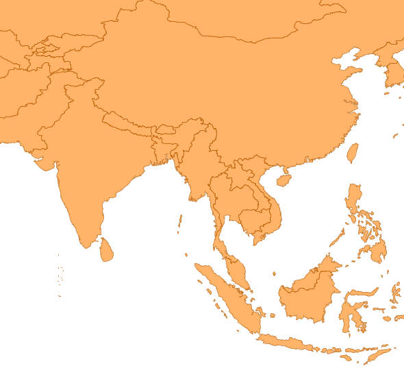
Example with countries
Simplification tolerance: 0.3 degrees ![]()
create table simple_countries as (
    select * from simplifyLayerPreserveTopology('countries', 'gid', 'geom', 0.3) as (gid int, geom geometry);
 | 
|
ToDo
Handle enclosed polygons cases.
Attachments (9)
-
SPT_dept_ori.png
(50.2 KB
) - added by 12 years ago.
Departement, originals
-
SPT_bad_attributes.png
(55.3 KB
) - added by 12 years ago.
simplified departements, bad attribute association
-
SPT_dept_sim.png
(45.6 KB
) - added by 12 years ago.
Final result
-
SPT_good_attributes.png
(55.2 KB
) - added by 12 years ago.
simplified departements, correct attribute association
-
SPT_islands_removed.png
(59.3 KB
) - added by 12 years ago.
simplified departements, zoom on simplified islands
-
SPT_simple_dept.png
(56.5 KB
) - added by 12 years ago.
simplified departements, with attributes
-
SPT_no_topo.png
(80.5 KB
) - added by 12 years ago.
simplified departements with broken topology
- world_before.png (72.0 KB ) - added by 12 years ago.
- world_after.png (67.4 KB ) - added by 12 years ago.
Download all attachments as: .zip