#5148 closed defect (fixed)
ST_Clip ERROR: rt_raster_from_two_rasters: The two rasters provided do not have the same alignment
| Reported by: | sergeish | Owned by: | robe |
|---|---|---|---|
| Priority: | medium | Milestone: | PostGIS 3.3.0 |
| Component: | raster | Version: | master |
| Keywords: | Cc: |
Description 
Called from RASTER_clip (ST_Clip), rt_raster_gdal_rasterize can produce mask raster that is not aligned with input raster.
In our case, the input geometry's (h3 index polygon) max. Y coordinate just happens to be within FLT_EPSILON distance from input raster Y coordinate.
This causes alignment step in rt_raster_gdal_rasterize to be skipped rt_raster.c:3075
Later in RASTER_clip -> rt_raster_from_two_rasters -> rt_raster_same_alignment -> rt_raster_geopoint_to_cell rt_rpatial_relationship.c:91 the difference get magnified by 1/scale (scale = 8.3333333333338033e-05) and position of upper left corner relative to raster becomes (0, -1) rt_raster.c:831 so alignment check correctly fails.
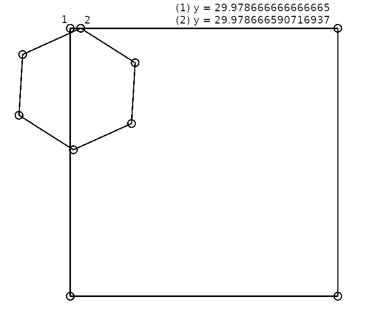
# SELECT ST_Clip(
  ST_AsRaster(
    ST_GeomFromText('POLYGON((-83.50933333333333 29.978666666666665,-83.488 29.978666666666665,-83.488 29.95733333333333,-83.50933333333333 29.95733333333333,-83.50933333333333 29.978666666666665))'),
256, 256),
  ST_GeomFromText('POLYGON((-83.50907828753448 29.968993886572754,-83.50444815780213 29.971082725355338,-83.50415647331064 29.97591893624371,-83.50849527658693 29.978666590716937,-83.51312588106222 29.976577808850404,-83.51341720749126 29.97174131559702,-83.50907828753448 29.968993886572754))'));
ERROR:  rt_raster_from_two_rasters: The two rasters provided do not have the same alignment
CONTEXT:  PL/pgSQL function st_clip(raster,integer[],geometry,double precision[],boolean) line 8 at RETURN
SQL function "st_clip" statement 1
Possible solutions for fixing alignment check in rt_raster_gdal_rasterize rt_raster.c:3075:
- take scale into account when checking if raster is already aligned, like (
FLT_EQ(fabs(grid_yw - extent.UpperLestY) / scale, 0.0)forscale < 1.0); - replace
FLT_EQwithDBL_EQ.
Is there a reason for using FLT_EQ for comparing doubles throughout raster code? This issue will be resolved as a special case if DBL_EQ is used instead.
Change History (5)
by , 3 years ago

comment:2 by , 3 years ago
As I recall there was an issue a long time ago like pre GDAL 2.0 with using double precision compare in postgis raster. I forget what it was. I suspect it's not relevant anymore, so I'd go ahead and flip to DBL_EQ if it fixes this.