#4211 closed defect (fixed)
ST_Subdivide() on geometries with rings
| Reported by: | morena | Owned by: | komzpa |
|---|---|---|---|
| Priority: | high | Milestone: | PostGIS 2.5.1 |
| Component: | postgis | Version: | 2.5.x -- EOL |
| Keywords: | ST_Subdivide | Cc: |
Description 
The ST_Subdivide() function on PostGIS 2.5.0 yields incorrect results for geometries (POLYGON) with rings (wholes).
To reproduce the issue:
DROP TABLE IF EXISTS test_geom;
CREATE TABLE test_geom AS
SELECT ST_GeomFromText('MULTIPOLYGON(((-88.2059 41.7325,-88.2060 41.7244,-88.1959 41.7241,-88.1959 41.7326,-88.2059 41.7325),(-88.1997 41.7289,-88.1996 41.7285,-88.1990 41.7285,-88.1990 41.7289,-88.1997 41.7289)))',4326) AS geom;

DROP TABLE IF EXISTS test_geom_result;
CREATE TABLE test_geom_result AS
SELECT ST_Subdivide(geom) AS geom FROM test_geom;
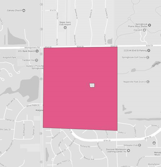
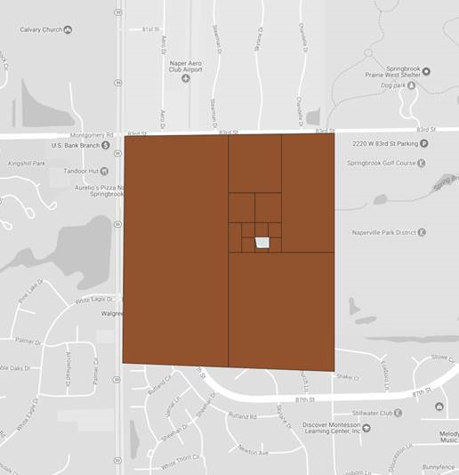
Attached are the previews of the above.
View of test geometry (on either PostGIS 2.4.4 or PostGIS 2.5.0):

View of result on PostGIS 2.4.4:

View of result on PostGIS 2.5.0:

The two outputs were tested on following setup: PostGIS 2.4.4
SELECT PostGIS_Full_Version();
POSTGIS="2.4.4 r16526" PGSQL="100" GEOS="3.7.0dev-CAPI-1.11.0 r" PROJ="Rel. 4.9.3, 15 August 2016" GDAL="GDAL 2.1.2, released 2016/10/24" LIBXML="2.9.4" LIBJSON="0.12.1" RASTER
PostGIS 2.5.0
SELECT PostGIS_Full_Version();
POSTGIS="2.5.0 r16836" [EXTENSION] PGSQL="110" GEOS="3.7.0-CAPI-1.11.0 673b9939" PROJ="Rel. 4.9.3, 15 August 2016" GDAL="GDAL 2.3.2, released 2018/09/21" LIBXML="2.9.4" LIBJSON="0.12.1" RASTER
Change History (11)
by , 6 years ago
| Attachment: | test_geom.png added |
|---|
by , 6 years ago
| Attachment: | postgis_2.4.4_test_geom_result.png added |
|---|
by , 6 years ago
| Attachment: | postgis_2.5.0_test_geom_result.png added |
|---|
comment:1 by , 6 years ago
comment:2 by , 6 years ago
| Owner: | changed from to |
|---|---|
| Priority: | medium → high |
with ST_Subdivide(geom, 8) I am able to reproduce the issue.

comment:7 by , 6 years ago
morena, please try updating from latest branch and check that your data is all OK now. The case you reported should be OK starting from PostGIS 2.5.1.
Note:
See TracTickets
for help on using tickets.
Cannot reproduce.
Result I get:
is expected, as your geometry is already below default 256 points. What are you using for rendering? May it happen interior ring is lost somewhere else in the process?