Opened 13 years ago
Last modified 8 years ago
#1457 new defect
Tiger Geocoder poorly handles business route abbreviations
| Reported by: | arencambre | Owned by: | robe |
|---|---|---|---|
| Priority: | medium | Milestone: | PostGIS Fund Me |
| Component: | tiger geocoder | Version: | master |
| Keywords: | Cc: | aren@… |
Description 
Roads may have "business routes". See http://en.wikipedia.org/wiki/Business_route for more details.
In the Tiger dataset for Texas, there is State Highway 121, and this highway has a few business routes.
One SH 121 business route in Coppell is called State Highway 121H Bus in the Tiger dataset.
Note that The H is just an internal Texas DOT designation and virtually never appears on road signs. It separates different business routes of a highway. There could also be SH 121A Bus, SH 121B Bus, etc.
Anyway, if I try this, I get no results:
SELECT ST_AsEWKT(geomout) FROM geocode_intersection('State Highway 121', 'Business 121', 'TX', 'Coppell') ORDER BY rating ASC LIMIT 1;
SELECT ST_AsEWKT(geomout) FROM geocode_intersection('State Highway 121', 'Bus. 121', 'TX', 'Coppell') ORDER BY rating ASC LIMIT 1;
Business 121 is a common way of referring to the road, and Bus. is an abbreviation of 121.
There's only one SH 121 Business in Coppell, TX, so seems like these should have matched.
Change History (6)
comment:1 by , 13 years ago
| Component: | postgis → tiger geocoder |
|---|---|
| Owner: | changed from to |
by , 13 years ago
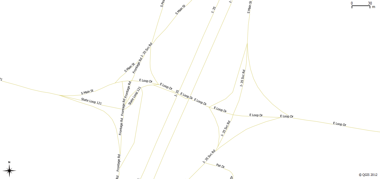
A picture of what I'm talking about in the first comment.
comment:2 by , 13 years ago
| Milestone: | PostGIS 2.0.0 → PostGIS 2.1.0 |
|---|
this one I'm not sure I'll have time to resolve before 2.0
comment:3 by , 12 years ago
| Milestone: | PostGIS 2.1.0 → PostGIS 2.2.0 |
|---|
comment:4 by , 10 years ago
| Milestone: | PostGIS 2.2.0 → PostGIS Future |
|---|
Here's some more that don't work but ought to.
Both of these finds a location a few hours drive time away, just east of the intersection of State Loop 121 and I-35:
SELECT ST_AsEWKT(geomout) FROM geocode_intersection('State Highway 121', 'State Highway 121 Bus', 'TX', 'Coppell') ORDER BY rating ASC LIMIT 1;
SELECT ST_AsEWKT(geomout) FROM geocode_intersection('State Highway 121', 'Bus. 121', 'TX', 'Coppell') ORDER BY rating ASC LIMIT 1;
Strangely, the actual road it's matching on is the intersection of E Loop Dr and an unnamed connector lane between that street and northbound I-35 Svc Rd. This is just east of I-35. The tx_edges table turns E Loop Dr into State Loop 121 on the west side of I-35!
The TIGER name of the correct road is again State Highway 121H Bus. It is again about a 2-3 hour drive from Coppell to Belton, TX, where this 121 loop is.