
| Version 28 (modified by , 4 years ago) ( diff ) |
|---|
Table of Contents
GSoC 2021: Improved Integration of GRASS GIS and Jupyter Notebooks 
| Title: | Improved Integration of GRASS GIS and Jupyter Notebooks |
| Student Name: | Caitlin Haedrich, North Carolina State University |
| Organization: | OSGeo - Open Source Geospatial Foundation |
| Mentor Name: | Vaclav Petras, Helena Mitasova, Stephan Blumentrath |
| GitHub Fork: | View Repo |
| GSoC proposal: | View Proposal |
Try grass.jupyter in Binder here
Abstract 
The previous integration of GRASS GIS and Jupyter Notebooks required a cumbersome environment variable setup after launching GRASS from within the notebook and only allowed for simple, non-interactive map displays. The grass.jupyter subpackage for addresses both these issues by introducing a new startup function, init(), and two display classes, GrassRenderer and InteractiveMap. GrassRenderer renders GRASS displays as PNG images using a more intuitive syntax. InteractiveMap displays rasters and vectors interactively with folium, a leaflet library for Python.
Goal 
This project had three main objectives:
- creating new initiation functions for the launch of GRASS GIS in Jupyter Notebooks (
init())
- creating functions for more intuitive map display (
GrassRenderer())
- introducing an interactive map display function (
InteractiveMap())
Timeline 
Time Period | Milestones | |
|---|---|---|
Tasks | Status | |
May 17th - June 7th |
|
Ok |
June 7th - June 11th |
|
Ok |
June 14th - June 18th |
| Ok |
June 21st - June 25 |
|
Ok |
June 28 - July 2 |
| Ok |
July 5th - July 9th |
|
Ok |
July 12th - July 16th |
|
Ok |
July 19th - July 23rd |
|
Ok |
July 26th - July 30th |
|
Ok |
August 2nd - August 6th |
|
Ok |
August 9th - August 13th |
|
Ok |
August 16th- August 23rd |
|
Ok |
Bonding period report 
With the bonding period wrapped up, here is a brief update on what I've been working on so far.
- What did I accomplish during the bonding period?
- I introduced myself in dev and SOC mailing lists (1).
- I had a productive meeting with my mentors, Vashek Petras, Helena Mitasova and Stefan Blumentrath last Friday. We discussed the best development environment (see second to last bullet point) and setting up the main GRASS repository to run in Binder (see last bullet point).
- Prepared the wiki page.
- Set up the GitHub repository for project (2).
- Set up developer environment. Since development will be easier on Linux, I set up a VirtualBox with Linux (Ubuntu) on my Windows machine. I compiled and installed GRASS and installed Jupyter Notebooks in Ubuntu.
- Opened my first PR (3) which contains binder dependencies.
- What do you plan on doing next week?
I've started working on setting up the GRASS repository to run in Binder (3). This week I plan to continue working on that, set up branches for each of the PRs, and begin writing functions for the grass.jupyter library.
- Are you blocked on anything?
No, I'm not currently blocked on anything.
Weekly reports 
Week 1 
With Week 1 wrapping up, here is an update on what I worked on this week and where I'm headed next week.
1) What did I get done this week?
- Finished binder setup for GRASS main repo. PR was approved. There's a new folder in the main GRASS repo that contains the necessary files to launch the repository in binder.
- Added Binder Button. PR under review. This button will go in the README.md and allow users to launch a Jupyter Lab of the repository in binder. Users can run GRASS (i.e. a compiled version of the main GRASS repo) in Jupyter Notebooks there.
- Created an example notebook that is linked from the Binder Button. The notebook was copied from here and demonstrates the existing Jupyter/GRASS integration.
- Wrote draft of GRASS initiation functions for Jupyter (PR).
- Created Makefile and init.py file for grass.jupyter (PR).
- Created a Jupyter Notebook where others can view and test the grass.jupyter functions (PR).
2) What do I plan on doing next week?
I plan to start working on display functions and familiarizing myself with Folium.
3) Am I blocked on anything? No, I'm not currently blocked on anything.
Week 2 
Here is a brief update from Week 2. You can also check out how the new grass.jupyter module works so far in Binder at this link
1) What did I accomplish this week?
- Had a productive discussion with my mentors: Vaclav Petras, Helena Mitasova and Stefan Blumentrath.
- Edited and merged Binder button into README PR and GRASS session initiation functions for Jupyter PR.
- Wrote functions for displaying non-interactive maps in Jupyter and opened PR for discussion PR.
- Began researching and drafting interactive display options with folium. In particular, figuring out how to best pass GRASS data/layers to folium.
2) What do I plan on doing next week?
- Edit non-interactive display functions.
- Continue working on passing GRASS data/layers to folium.
3) Am I blocked on anything? No, I'm not blocked but I didn't get much done this week because I had a family event.
Any suggestions and feedback are welcome!
Week 3 
Here is a brief update on what I accomplished during Week 3 of Google Summer of Code for the new GRASS library grass.jupyter. I have also started posting links to Binder Jupyter Notebooks in each PR if you would like to try any of the features and functions I've been working on.
1) What did I accomplish this week?
- Edited and discussed functions for displaying non-interactive maps in Jupyter PR.
- Drafted an interactive display function for rasters with folium PR.
- Made a few minor edits to the example_notebook.ipynb that is linked in the README PR.
2) What do I plan on doing next week?
- I have a meeting planned with my mentors.
- I will continue working on interactive functions for Jupyter. In particular, I'm working on passing GRASS rasters to folium.
- I'll begin writing functions for displaying GRASS vectors with folium.
3) Am I blocked on anything? I'm not blocked at the moment. But, I have been working on finding a good way to pass raster data between GRASS and Jupyter and I'm not sure my current method is particularly fast or robust [3]. Luckily, I have a meeting tomorrow with my mentors where we will discuss this.
Any suggestions and feedback are welcome!
Week 4 
With week 4 wrapping up, here is a brief update of what I've been working on. Per usual, you can try proposed changes out in the Binder link in the description of each PR.
1) What did I accomplish during Week 1?
- I had a productive meeting with my mentors: Vaclav Petras, Helena Mitasova and Stefan Blumentrath. We discussed how environments work and the purpose of copying the environment each time an instance of GrassRenderer is called.
- I finished and merged a class called GrassRenderer for non-interactive map displays PR.
- I continued to work on interactive mapping with folium. In particular, I changed how data is passed to folium so that it is first reprojected to WGS84 (required by folium/leaflet) in a new location/mapset PR.
2) What do I plan on doing next week?
- Continue to work on interactive functions with folium.
3) Am I blocked on anything?
- No, I'm not blocked on anything at the moment.
Any suggestions and feedback welcome!
Week 5 
Here is a weekly update on my project, Improved Integration of GRASS GIS and Jupyter Notebooks.
1) What did I accomplish this week?
- This week, I spent most of my time improving and editing a new class called
InteractiveMapto display vectors interactively with folium. You can test the current functionality in Binder. - I had a productive meeting with my mentor, Vaclav Petras on Thursday. We discussed several things that I was a little stuck on and had questions about.
- Updated
grass.jupyterdemonstration Notebook. - Resolved merge conflicts with master - now, the interactive and non-interactive classes are functional together PR.
- Found unexpected behavior in the legend display. Calling folium.map.LayerControl() adds a legend to the map but also seems to prevent further modification of the map.
2) What do I plan to do next week?
- Meet with my mentors tomorrow.
- GSoC Evaluations.
- Finish and merge interactive vector methods.
- Begin interactive maps for rasters.
3) Am I blocked on anything?
- No, I'm not currently blocked on anything.
Feedback, comments, questions and ideas welcome!
Week 6 
Here's a weekly update on my GSoC project, Improved Integration of GRASS GIS and Jupyter Notebooks.
1) What did I accomplish this week?
- This week, I had two meetings with my mentor, Vaclav Petras. We've been discussing how to improve my workflow, best practices and conventions for GRASS and Python and questions that come up as I'm working.
- Instituted the use of temporary PNG files for displaying static/non-interactive maps PR and temporary directories for passing vectors between GRASS and folium link (PR coming soon).
- Continued to edit the InteractiveMap class and mapping GRASS vectors in folium PR
- Created a shortcut for calling GRASS display modules using getattr PR
- Completed evaluation and received feedback.
2) What do I plan to do next week?
- I have another meeting planning with Vaclav tomorrow.
- Finish and merge existing PRs
- Continue writing test module for Non-Interactive Vectors
- Support Raster display in folium map
- Clean-up function
3) Am I blocked on anything?
- No, I'm not currently blocked on anything.
Feedback, comments, questions and ideas welcome!
Week 7 
Here's a quick update on what I worked on this past week.
1) What did I accomplish this week?
- This week, I had another two meetings with my mentor, Vaclav Petras. We've been discussing best practices and conventions for GRASS and Python and questions that come up as I'm working.
- Merged 'add_vector' method for InteractiveMaps in folium [2].
- Improved error handling and documentation on the shortcut for calling GRASS display modules for "GrassRenderer" [3].
- Wrote a test module for the "GrassRenderer" class - a class which displays GRASS maps in Jupyter Notebooks as PNG images. I haven't opened a PR since there are a couple things I need to add after some other PRs are merged.
- Continued to work on overlaying rasters in folium - this is taking me a while because the raster and raster bounds have to be reprojected since folium only takes WGS84 and Pseudo-Mercator projections.
2) What do I plan to do next week?
- I have another meeting planning with Vaclav on Monday.
- Finish and merge existing PRs
- Continue writing test module for GrassRenderer
3) Am I blocked on anything?
- No, I'm not currently blocked on anything.
Feedback, comments, questions and ideas welcome!
Week 8 
Here's a quick update on what I worked on this past week. I came down with a stomach bug this week and didn't get as much as I hoped done but I did wrap up some things I'd been working on for a while.
1) What did I accomplish this week?
- I had a brief meeting with my mentor, Vaclav Petras. We discussed some of the existing PR's I had open and goals for the rest of the summer.
- Got rasters to display with folium (finally)! You can check out the functionality in Binder here and see the PR here. It takes a while to reproject the raster (folium only excepts rasters in Pseudo-mercator). As Stefan recommended, I'm hoping to write a "simple CRS" option that won't require reproject and will be faster. But that's for next week...
- Merged shortcuts and temporary files for
GrassRenderer(PR and PR). - Continued working on test script for
GrassRenderer, the non-interactive display class PR.
2) What do I plan to do next week?
- I have a meeting with my mentors planned for tomorrow
- Add simple CRS option for raster display in folium
- Edit and finish exiting PRs
- Add option to save/export folium map as HTML
3) Am I blocked on anything?
- No, I'm not currently blocked on anything.
Feedback, comments, questions and ideas welcome!
Week 9 
Happy last week of coding! Here's an update of my GSoC project, "Improved Integration of GRASS GIS and Jupyter Notebooks."
1) What did I accomplish this week?
- I had a meeting with my mentors, Vaclav Petras and Helena Mitasova. We discussed some of the existing PR's and goals for the rest of the summer.
- Rasters reproject and display much faster now! You can test it out in Binder. As Vaclav pointed out, it was oversampling the raster when it reprojected - adding a method to estimate the resolution in target location fixed this.
- Re-arranged code for InteractiveMap and improved documentation PR
- Added save as HTML method for InteractiveMap PR
2) What do I plan to do next week?
- I have a meeting with my mentors planned for today
- Add simple CRS option for raster display in folium
- Finish test script PR
- Improve/finish GRASS-Jupyter Demonstration notebook
3) Am I blocked on anything? No, I'm not currently blocked on anything.
Feedback, comments, questions and ideas welcome!
Week 10 
Last week of coding! Here's an update on how the project is progressing
1) What did I accomplish this week?
- I had a meeting with my mentors, Vaclav Petras and Stephan Blumentrath. We discussed goals for the rest of the summer and decided to leave the simple CRS for future work.
- Merged raster support in folium to main! It was a pretty substantial PR in the end PR
- Began improving example notebooks and adding additional tutorials.
2) What do I plan to do next week?
- Finalize docstrings
- Finish example notebooks
- Evaluations and final submission
3) Am I blocked on anything? No, I'm not currently blocked on anything.
Feedback, comments, questions and ideas welcome - especially for Future Work!
Final Report 
Title: Improved Integration of Grass GIS and Jupyter Notebooks
Community: GRASS GIS - OSGeo
Abstract:
This project introduces a new subpackage for GRASS GIS, grass.jupyter that improves the integration of GRASS GIS with Jupyter Notebooks. Previously, using GRASS in Jupyter Notebooks required a cumbersome environment variable setup after launching GRASS from within the notebook and only allowed for simple, non-interactive map displays. The grass.jupyter subpackage addresses both these issues by introducing a new startup function, init(), and two display classes, GrassRenderer and InteractiveMap. GrassRenderer renders GRASS displays as PNG images using an intuitive syntax. InteractiveMap displays rasters and vectors interactively with folium, a leaflet library for Python.
The state of integration BEFORE the start of GSoC:
The previous integration of GRASS GIS and Jupyter Notebooks required a cumbersome environment variable setup after launching GRASS from within the notebook. There is an external python library grass_session that can be installed to shorten this launch substantially but, as an external library, it is not included in a typical GRASS install. Additionally, the previous integration allowed for maps to rendered as PNG images uses a unintuitive sequence of calling d.erase, then modules from the display family and finally rendering the image with IPython.display Image(). For an example this workflow, see basic_example.ipynb.
The state of integration AFTER GSoC:
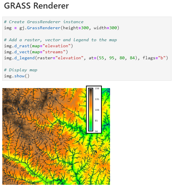
With the help of my mentors, I introduced a new package grass.jupyter that contains a new init() function to shorten the launch and two display-related classes, GrassRenderer and InteractiveMap. GrassRenderer wraps the previous approach, rendering PNG images but with a more intuitive syntax. Users create an instance of GrassRenderer then add elements to the rendering with GRASS display modules. The GRASS modules are called by using the name of module as a class method and replacing "." with "_" in the name. For example, to add a raster, one would call GrassRenderer.d_rast(map="raster_name").
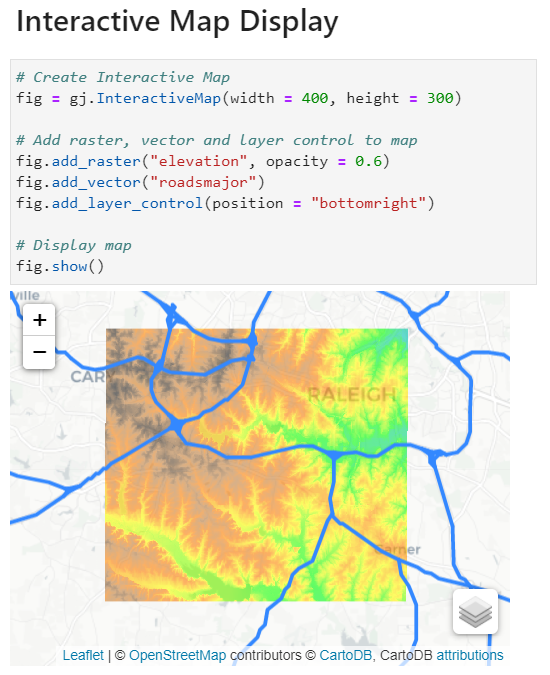
InteractiveMap, the other display-related class in grass.jupyter, allows users to view GRASS vectors and rasters in folium, a leaflet library for Python. After creating an instance of InteractiveMap, users can add vectors and rasters with add_vector() and add_raster(). Users can also add a layer control element with add_layer_control(). Folium only supports EPSG 4326 (for raster overlay) and EPSG 3857 (for vectors and coordinates) so InteractiveMap creates a temporary location, reprojects data then saves it to a temporary directory where it is imported by folium.
Conclusion:
In this project, I was successful in accomplishing the three goals stated at the beginning (thanks to my mentors!):
- creating new initiation functions for the launch of GRASS GIS in Jupyter Notebooks (
init())
- creating functions for more intuitive map display (
GrassRenderer())
- introducing an interactive map display function (
InteractiveMap())
The work I accomplished this summer paves the way for many future improvements, listed below in the Future Work section. In addition to some smaller modifications to init() and 'GrassRenderer', there remains a lot of work to be done on InteractiveMap or with other folium-GRASS class to fully access folium. I am grateful for the support I've received this summer and for the opportunity to contribute to GRASS GIS. I'm looking forward to continuing to improve grass.jupyter.
Future Work:
- Height and width defaults in
GrassRenderershould be derived from computational region init()should fail and report an appropriate error if a mapset that doesn't exist is provided- Add folium Tooltip method to
InteractiveMap, allowing users to access vector attribute data by clicking on feature - Add simpleCRS option to
add_rastermethod inInteractiveMap - Add option to display rasters as vectors (pixels -> polygon) in
InteractiveMap - Clip vectors to computational region in
InteractiveMap(currently the whole vector dataset is displayed) - Add more interactive functions: timeline slider for temporal datasets, etc.
InteractiveMapdoesn't allow users to fully access folium. In the future, a new interface that allows users direct access to folium should be added. For example, it could look like:gj.Raster("elevation").add_to(folium_map))
Permanent Links:
Pull requests related to grass.jupyter:
| Title | Pull Request |
| Added Binder setup files | https://github.com/OSGeo/grass/pull/1603 |
| Binder Button | https://github.com/OSGeo/grass/pull/1628 |
| Session Initiation functions for Jupyter Notebooks | https://github.com/OSGeo/grass/pull/1629 |
| Added additional GRASS info to example_notebook | https://github.com/OSGeo/grass/pull/1686 |
| Jupyter: Non-interactive display | https://github.com/OSGeo/grass/pull/1668 |
| Interactive vector maps for Jupyter Notebooks | https://github.com/OSGeo/grass/pull/1710 |
__getattr__ shortcut for calling GRASS display modules | https://github.com/OSGeo/grass/pull/1723 |
| Add temporary files for Non-Interactive Display | https://github.com/OSGeo/grass/pull/1727 |
| Raster Support for Interactive Jupyter maps with folium | https://github.com/OSGeo/grass/pull/1769 |
| Test Module for Non-interactive display in Jupyter Notebooks | https://github.com/OSGeo/grass/pull/1739 |
| Docstring improvements | https://github.com/OSGeo/grass/pull/1800 |
| Example notebooks | https://github.com/OSGeo/grass/pull/1787 |
OSGeo Wiki Page:
https://trac.osgeo.org/grass/wiki/GSoC/2021/JupyterAndGRASS
OSGeo-GRASS !github project page:
https://github.com/OSGeo/grass/projects/7
Github Fork and grass.jupyter directory:
https://github.com/chaedri/grass/tree/master/python/grass/jupyter
Binder Examples:
grass_jupyter.ipynb
basic_example_grass_jupyter.ipynb
Images 


Attachments (2)
- GrassRenderer.PNG (340.4 KB ) - added by 4 years ago.
- InteractiveMap.PNG (291.9 KB ) - added by 4 years ago.
Download all attachments as: .zip