
| Version 27 (modified by , 11 years ago) ( diff ) |
|---|
Table of Contents
GSoC 2014 Metadata for GRASS GIS maps and datasets
| Title: | Metadata for GRASS GIS maps and datasets |
| Student Name: | Matej Krejci, Czech Technical University in Prague |
| Organization: | OSGeo - Open Source Geospatial Foundation |
| Mentor Name: | Martin Landa, Margherita Di Leo |
| GSoC proposal: | view proposal |
Motivation
Current GRASS GIS offers just a poor and out-of-date administration of metadata. The goal of this project is to implement administration of metadata according to the standards of ISO 19115, ISO 19139 and to create a graphical user interface which would allow the user to operate with metadata, such as creating, updating, browsing, searching etc.
Timeline
| timeline from proposal | newly proposed timeline | |
| MAY 1- 7 | "Early starts" Study ISO, INSPIRE and FGDC standards | |
| MAY 7 - 14 | Getting familiar with GRASS GIS modules code. | |
| MAY 14 - 19 | Design of metadata GRASS library | design GRASS library (in Python) to read / write metadata based on ISO as flat XML files |
| MAY 19 | Starting GoSC x | |
| MAY 19- 25 | Support of diferent metadata profiles | design GRASS library (in Python) to read / write metadata based on ISO as flat XML files including profies (XSD validation, Inspire as the show-case) |
| MAY 26 - JUN 16 | "Break"(Prepare for bachelor final exam) | add support for conversion GRASS (current) metadata files <-> XML ISO metadata |
| JUN 16 - 24 | Implement basic library model for command line | design cmd modules for reading and writing ISO-based metadata -> r.info.iso + v.info.iso (including support for conversion GRASS (current) metadata files <-> XML ISO metadata) |
| JUN 24 - 30 | Modules functionality (searching, publishing metadata) | design GUI for reading and writing ISO-based metadata |
| JULY 1 - 7 | Design GUI | design GUI for reading and writing ISO-based metadata -> g.gui.metadata |
| JULY 7 - 14 | Connect GUI library, basic functions | advanced metadata publishing/searching based on owslib + pycsw |
| JULY 14 - 21 | Implementation of search function to GUI | advanced metadata publishing/searching based on owslib + pycsw |
| JULY 21 - 30 | Improve metadata validation using designed GUI | advanced metadata publishing/searching based on owslib + pycsw -> testing prototype |
| AUGUST 1 - 9 | Polishing code | polishing code |
| AUGUST 9 - 18 | Testing and documentation | testing and documentation |
| AUGUST 18 | The end of GSoC | the end of GSoC |
Weekly reports
Week 1 (May 23)
studied metadata and tried to find suitable python lib during last three weeks:
- studied ISO 19115 and EN ISO 19119
- INSPIRE
- be advised to leave out implementation of FGDC - just ISO, INSPIRE
- get familiar with OWSLib and pycsw
- set pycsw metadata server catalog
- handled metadata by OWSLib
- spent time with design lib based on automated generation of XML from XSD - failed
- tested suitability of generateDS to generate python object from XML scheme (XSD)
- designed library for parse GRASS GIS metadata to XML based on md. ISO
- parsed metadata from:
- r.info
- v.info
- g.proj
- parsed metadata from:
- designed essential metadata profile for raster and vector maps (based on ISO standard)
- prepared lib for new update of OWSLib that will be ready during next week. (in contact with author)
- created new timeline - main changes:
- will create basic metadata management based on creating, editing, validating ISO. (obligatory)
- will create advanced management based on client-server with using pycsw. (optional)
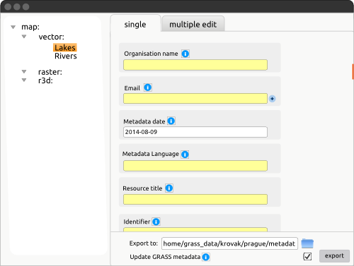
Attachments (9)
- main.png (15.6 KB ) - added by 11 years ago.
- prototyp1.png (30.3 KB ) - added by 11 years ago.
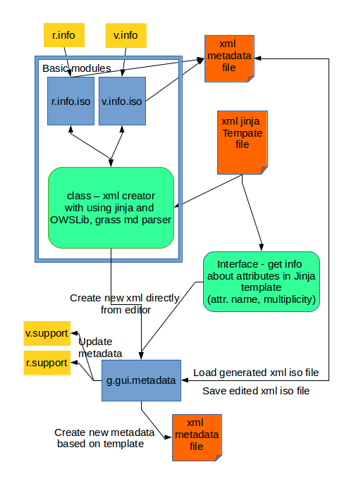
- diagram.png (76.3 KB ) - added by 11 years ago.
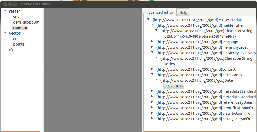
- md_editor1.png (87.8 KB ) - added by 11 years ago.
- gui.png (12.9 KB ) - added by 11 years ago.
- gui1.png (25.2 KB ) - added by 11 years ago.
- g.gui.metadata1.jpg (195.3 KB ) - added by 11 years ago.
- templateCreator.png (108.0 KB ) - added by 11 years ago.
- multiSel.png (45.9 KB ) - added by 11 years ago.
Download all attachments as: .zip
Note:
See TracWiki
for help on using the wiki.