
Opened 8 years ago
Last modified 6 years ago
#3279 new enhancement
Add Region tab to the main GUI
| Reported by: | wenzeslaus | Owned by: | |
|---|---|---|---|
| Priority: | major | Milestone: | 7.6.2 |
| Component: | wxGUI | Version: | svn-trunk |
| Keywords: | g.region, extent, resolution, novice, beginner, user-friendliness | Cc: | |
| CPU: | Unspecified | Platform: | Unspecified |
Description 
I suggest to add another tab to the Layer Manager which would handle (and show) all things related to the (current) computational region. The name I suggest for the tab is Region and the order:
- Layers
- [3D view]
- Console
- Region
- Modules
- Data
- Python
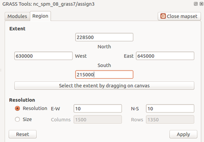
I'm not sure how it should look like or how it should be updated (it can be modified from outside of the widget). There can be only basic functionality and button to start g.region (see Modules tab). For example, if the tab is active, the Map Display could active the "Show comp. extent" option. I'm attaching a screenshot of how this looks like in the QGIS GRASS plugin. I'm not sure about the aesthetics of it, but the functionality is probably at least the minimum of what we want. I'm not sure how nswe are useful but we can add raster and vector option and the alignment function (although they are probably better handled through Layers), -a flag, named regions ("bookmarking") and maybe other things handled from Map Display.
This may raise awareness of new users about computational region and encourage all users to remember it before running modules. There can be even a short explanation what does it do.
Problems:
- Name: Region is not completely clear, but we decided to go with one word, so Computational Region is not an option. g.region would be less readable for novices and inconsistent.
- Although for English there is still space even when 3D view is active, we may be running out of space for some languages.
- How many of these tabs do we what to add (allowed to be added) there?
- Spatial Database, Location, Mapset
- Thing related to Map Display, Vector Digitizer, ... (as for 3D view)
- General preferences which needs to be changed often (Map Display color, font, projection statusbar settings)
- Documentation (Doc, Man)
- R, Jupyter Notebook, ...
Change History (14)
by , 8 years ago
| Attachment: | qgis_grass_plugin_region_tab.png added |
|---|
by , 8 years ago
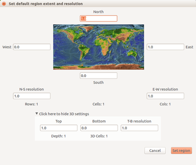
| Attachment: | grass_set_default_region_dialog.png added |
|---|
Set default (computational) region extent and resolution dialog in GRASS GIS (after Location Wizard)
comment:1 by , 8 years ago
Replying to wenzeslaus:
I suggest to add another tab to the Layer Manager which would handle (and show) all things related to the (current) computational region. The name I suggest for the tab is Region and the order:
strong +1
follow-up: 4 comment:2 by , 8 years ago
Replying to wenzeslaus:
This may raise awareness of new users about computational region and encourage all users to remember it before running modules.
In the same scope, what about greying out the space around the region extent ?
follow-ups: 5 6 comment:3 by , 8 years ago
Replying to wenzeslaus:
I suggest to add another tab to the Layer Manager which would handle (and show) all things related to the (current) computational region.
[...]
This may raise awareness of new users about computational region and encourage all users to remember it before running modules. There can be even a short explanation what does it do.
Nice idea !
As we are speaking about this: It would be great if the computational extent and resolution dialog would allow drawing the region extent interactively. I guess this would probably mean some call to OSM or similar in order to display a meaningful map at different zooming levels.
Problems:
- Name: Region is not completely clear, but we decided to go with one word, so Computational Region is not an option. g.region would be less readable for novices and inconsistent.
- Although for English there is still space even when 3D view is active, we may be running out of space for some languages.
- How many of these tabs do we what to add (allowed to be added) there?
- Spatial Database, Location, Mapset
- Thing related to Map Display, Vector Digitizer, ... (as for 3D view)
- General preferences which needs to be changed often (Map Display color, font, projection statusbar settings)
- Documentation (Doc, Man)
- R, Jupyter Notebook, ...
I think we should not overdo it with these tabs, or we should allow activating/desactivating (some of them). IMHO, the idea should not be to put all of GRASS GIS into wxGUI tabs ;-)
comment:4 by , 8 years ago
Replying to vincent:
Replying to wenzeslaus:
This may raise awareness of new users about computational region and encourage all users to remember it before running modules.
In the same scope, what about greying out the space around the region extent ?
Please, create a separate ticket for it.
comment:5 by , 8 years ago
Replying to mlennert:
As we are speaking about this: It would be great if the computational extent and resolution dialog would allow drawing the region extent interactively. I guess this would probably mean some call to OSM or similar in order to display a meaningful map at different zooming levels.
This may be better discussed in a separate ticket. There is a lot of details to discuss. The Region tab is integrated in GUI, so using Map Display seems to be the most straightforward option.
comment:6 by , 8 years ago
Replying to mlennert:
Replying to wenzeslaus:
Problems:
- How many of these tabs do we what to add (allowed to be added) there?
- Spatial Database, Location, Mapset
- Thing related to Map Display, Vector Digitizer, ... (as for 3D view)
- General preferences which needs to be changed often (Map Display color, font, projection statusbar settings)
- Documentation (Doc, Man)
- R, Jupyter Notebook, ...
I think we should not overdo it with these tabs [...] the idea should not be to put all of GRASS GIS into wxGUI tabs
Agreed. And there is more danger... Workspace(s)/Projects, Mask
or we should allow activating/desactivating (some of them).
That's possible for some: Settings > Preferences > General > Hide 'X' tab where X is Modules or Python. The Data tab should be in this list as well and same for Region. We can even consider hiding the Console tab and show it automatically when an error is printed. And of course 3D view is there already only when needed.
comment:8 by , 7 years ago
| Milestone: | 7.4.1 → 7.4.2 |
|---|
comment:9 by , 7 years ago
| Milestone: | 7.4.2 → 7.6.0 |
|---|
All enhancement tickets should be assigned to 7.6 milestone.
Region tab in the QGIS GRASS plugin