
Opened 13 years ago
Closed 13 years ago
#1462 closed defect (invalid)
r.walk not working in Lambert Conformal Conic projection
| Reported by: | cmbarton | Owned by: | |
|---|---|---|---|
| Priority: | critical | Milestone: | 6.4.2 |
| Component: | Raster | Version: | svn-releasebranch64 |
| Keywords: | r.walk | Cc: | cgravelm@… |
| CPU: | Unspecified | Platform: | Unspecified |
Description 
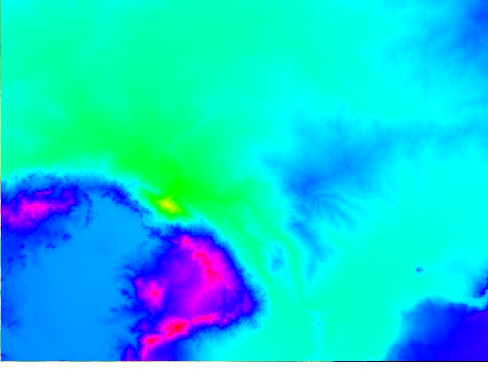
r.walk seems to be ignoring topography in a Lambert projection. r.cost works fine. I'm attaching screen shots of an SRTM DEM of central Europe, the results of r.walk on that DEM (with a friction map of 1), and r.cost run on a slope map of the DEM from the same start point as r.walk.
Change History (7)
by , 13 years ago
| Attachment: | lambert_dem.jpg added |
|---|
by , 13 years ago
| Attachment: | lambert_rcost.jpg added |
|---|
r.cost output of slope map created from SRTM DEM (same starting point as r.walk map)
comment:1 by , 13 years ago
Please replace the attachment "lambert_dem.jpg" with a GeoTIFF containing the projection.
comment:2 by , 13 years ago
Markus,
Turns out my map is in Lambert Equal Area. My student's map is in Lambert Conformal Conic and gives the same result. A geotif of the DEM is 3.9 MB, which far exceeds the 256 Kb limit of the bug tracker. However, the world file for r.out.tif is
999.420668933852198
0.000000000000000
0.000000000000000
-1000.379912587064837
4927643.608154466375709
3452811.268273706547916
...and g.proj gives the following:
g.proj -p
-PROJ_INFO-------------------------------------------------
name       : Lambert Azimuthal Equal Area
proj       : laea
a          : 6378137
es         : 0.006694379990141282
lat_0      : 52
lon_0      : 10
x_0        : 4321000
y_0        : 3210000
towgs84    : 0,0,0,0,0,0,0
no_defs    : defined
-PROJ_UNITS------------------------------------------------
unit       : meters
units      : meterss
meters     : 1
I can post the DEM somewhere if you want
Michael
comment:3 by , 13 years ago
From the dev ml, Oct 11 2011, Claudine Gravel Miguel:
"I think I've found what I thought it wasn't working. I reran the whole thing on both UTM and conical and when looking at a big region, it seemed like it wasn't working, but as soon as I zoom the window on the 'center' point and I recalibrate the colors of the r-walk output, then the paths appear to be fine, on both locations. I also ran the whole thing in both 6.4.2 and 7 and both works fine. I wonder if the problem you had is the same, Michael, or if it was different.
I think that te reason why I thought the circle around the center point was wrong is because I was comparing it to r.walk in lat long, which was following very closely the results found in r.cost (following the valleys), which, I know realize, were the wrong type of outcome.
So, I guess my part of the problem is resolved. Thanks for your help!"
Close ticket?
Markus M
comment:4 by , 13 years ago
| Resolution: | → invalid |
|---|---|
| Status: | new → closed |
I have not personally tested, but Claudine did. It looks like we were having a similar issue to what you found. I supposed we should close this.
Michael
1km SRTM DEM of central Europe