Opened 10 years ago
Last modified 10 years ago
#5497 closed defect
Sporadic repeatable errors in png output of gdaldem -color-relief — at Initial Version
| Reported by: | YellowBeard | Owned by: | warmerdam |
|---|---|---|---|
| Priority: | normal | Milestone: | |
| Component: | Algorithms | Version: | 1.11.0 |
| Severity: | major | Keywords: | color-relief, gdaldem, DEM |
| Cc: |
Description
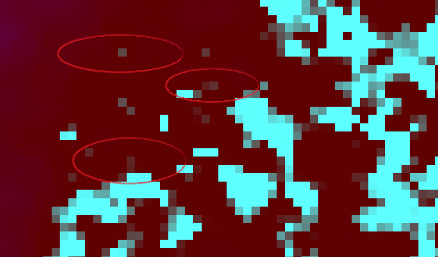
I have a AIG dataset of Queensland, Australia. In MapWindow, the data looks correct (with the exception of some systematic offset errors near the coast that aren't too serious).
When I run this file through gdaldem -color-relief, the output is almost correct, but with small regions of 'noise' that results in heights of 18,000ft, or -40,000ft, for example.
I am using the gdaldem from http://www.gisinternals.com/sdk/PackageList.aspx?file=release-1600-x64-gdal-1-11-mapserver-6-4.zip
my command is: gdaldem.exe color-relief "e153s29dem1_0\w001001.adf" "colourTextFile.txt" "deme153s29.png" -of PNG
Change History (2)
by , 10 years ago
| Attachment: | colourTextFile.txt added |
|---|
by , 10 years ago
| Attachment: | gdaldemPngOutputExample.png added |
|---|
Circled examples of incorrect png colours
Note:
See TracTickets
for help on using tickets.
Color mapping file