Opened 18 years ago
Closed 14 years ago
#54 closed enhancement (fixed)
label placement
| Reported by: | Owned by: | wonder | |
|---|---|---|---|
| Priority: | major: does not work as expected | Milestone: | Version 1.4.0 |
| Component: | MapCanvas | Version: | Trunk |
| Keywords: | Cc: | blake@…, mgalen@… | |
| Must Fix for Release: | Yes | Platform: | All |
| Platform Version: | Awaiting user input: | no |
Description
A wish: label placement should be improved, especially for printing, avoiding overlapping and collisions and repetion of the same label on several islands of the same feature.
Attachments (2)
Change History (20)
comment:1 by , 18 years ago
| Version: | → HEAD |
|---|
comment:2 by , 18 years ago
| Milestone: | → Version 0.9 Release |
|---|
comment:3 by , 18 years ago
comment:4 by , 17 years ago
| Awaiting user input: | unset |
|---|---|
| Must Fix for Release: | → No |
comment:5 by , 16 years ago
| Milestone: | Version 0.9.1 → Version 1.0 |
|---|
This really needs more time :-/
Martin
comment:6 by , 16 years ago
Hi,
You might look at v.label.sa in GRASS 6.3 for some nice algorithm,
v.label.sa: "Create paint labels, but use a Simulated Annealing algorithm to avoid overlaping labels."
"v.label.sa makes a label-file from a GRASS vector map with labels created from attributes in the attached table. The labels are placed in as optimal place as possible."
http://trac.osgeo.org/grass/browser/grass/trunk/vector/v.label.sa/ http://trac.osgeo.org/grass/browser/grass/trunk/vector/v.label.sa/annealing.c
good luck,
Hamish
comment:7 by , 16 years ago
| Cc: | added |
|---|
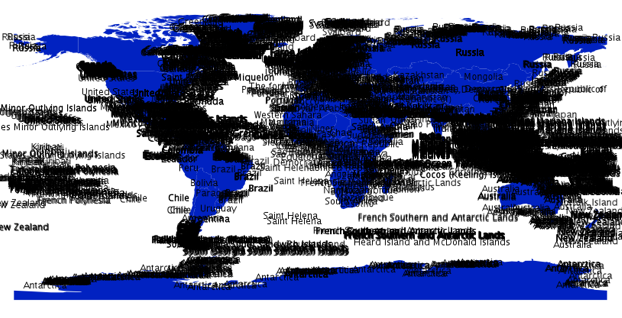
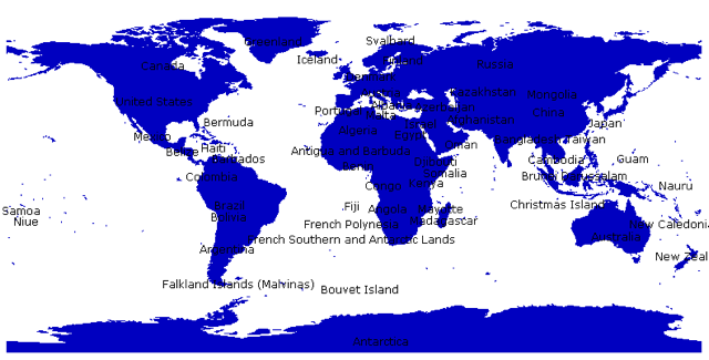
+ 1 on this being a fairly critical. I would support prioritizing default collision avoidance / filtering as a first feature. This could be a checkbox in the label tab that is on by default and would prevent layers from rendering all their labels when major overlap/collision will occur. This will help basic QGIS aesthetics and performance. An example of the performance hit is that when rendering a world_borders shapefile ( ~500kb) and all the country name labels are placed by default, QGIS hangs unresponsively for about 7 seconds. (I'm running 0.10.0 on Max OS 10.5 with 2GB ram and loading the shapefile from http://thematicmapping.org/downloads/TM_WORLD_BORDERS_SIMPL-0.2.zip).
I just ran a quick comparison with this same sample data in uDIG, Mapwindow, and ArcMap and all three have either a default collision algorithm set or an easy checkbox available to avoid collision and therefore render the world_borders shapefile much faster when labels are requested. This feature will have a big impact on the first-impressions of new users if implemented.
I'll attach two graphics comparing the default labeling in qgis with the default labeling in mapwindow (with collision avoidance).
by , 16 years ago
| Attachment: | qgis_world_borders_default_labeling.png added |
|---|
QGIS default labeling when collision occurs
by , 16 years ago
| Attachment: | mapwindow_world_borders_default_labeling.png added |
|---|
Mapwindow default labeling with collision avoidance on


comment:9 by , 16 years ago
| Cc: | added |
|---|
This will be addressed with the Google Summer of Code project to enhance labeling in QGIS.
comment:10 by , 16 years ago
Mapserver does the same thing (i.e. automatic removal of labels that collide until there are no collisions). See http://mapserver.gis.umn.edu/docs/reference/mapfile/label (POSITION directive) and http://trac.osgeo.org/mapserver/browser/trunk/mapserver/maplabel.c#L196
This doesn't mean the same code can be used, but it shouldn't be difficult to re-use at least the same algorithm used there.
comment:12 by , 16 years ago
| Must Fix for Release: | No → Yes |
|---|
comment:14 by , 16 years ago
| Milestone: | Version 1.0.0 → Version 1.1.0 |
|---|
We will be integrating the PAL label placement library for probably QGIS 1.1. They are finishing some changes and for other reasons we will not be applying this change in QGIS 1.0.
Regards
Tim
comment:15 by , 15 years ago
Hi,
just to note that the project "Label placement for Quantum GIS" by Martin Dobias has been accepted for the 2009 Google Summer of Code.
see http://www.osgeo.org/node/895
Hamish
comment:17 by , 15 years ago
| Component: | Graphics → MapCanvas |
|---|
comment:18 by , 14 years ago
| Resolution: | → fixed |
|---|---|
| Status: | new → closed |
This should be fixed with the new labelling framework now available in qgis-trunk.
See also ticket #297 for other label related enhancement requests