Opened 6 weeks ago
Closed 4 days ago
#5699 closed defect (fixed)
ERROR: XX000: SQL/MM Spatial exception - geometry crosses an edge
| Reported by: | Lars Aksel Opsahl | Owned by: | strk |
|---|---|---|---|
| Priority: | medium | Milestone: | PostGIS 3.4.3 |
| Component: | topology | Version: | 3.4.x |
| Keywords: | robustness | Cc: |
Description
When running attached before_error_2.sql it runs ok with no errors
PostgreSQL 12.6 (Ubuntu 12.6-0ubuntu0.20.04.1) on x86_64-pc-linux-gnu, compiled by gcc (Ubuntu 9.3.0-17ubuntu1~20.04) 9.3.0, 64-bit

POSTGIS="3.4.0 0874ea3" [EXTENSION] PGSQL="120" GEOS="3.12.1-CAPI-1.18.1" (compiled against GEOS 3.10.2) SFCGAL="1.3.7" PROJ="8.2.0 NETWORK_ENABLED=OFF URL_ENDPOINT=https://cdn.proj.org USER_WRITABLE_DIRECTORY=/tmp/proj DATABASE_PATH=/usr/share/proj/proj.db" GDAL="GDAL 3.4.3, released 2022/04/22" LIBXML="2.9.10" LIBJSON="0.13.1" LIBPROTOBUF="1.3.3" WAGYU="0.5.0 (Internal)" TOPOLOGY RASTER
But then I run line below and I get the topology error
SELECT topology.TopoGeo_addLinestring('tmp_dyrkbarjord_04_t3_a_test_issue_70_87','0102000020A2100000100000000D880F7BEC5930406F570C22A7305140C8AC7234EB5930405F149102A730514053CB13A4DA593040B76B72A1A5305140E8A20595C8593040E64298B4A43051400F88396EBD593040F7AD0040A4305140F45788B1AB5930405377D394A330514064D7228B9B593040E5B2F209A3305140FBEE4BCD895930409618A437A23051400AD56EC465593040D2CC44809F3051402EFFCCC95259304025A49FFC9D30514044D849034459304007A8D89F9C3051409F963BB333593040749B58689B3051406D643F49255930409399D1439A30514065EAA6911D593040CAF1A7BA99305140F63C2ACD16593040D2B1794C99305140558DD4BB19593040835BCB8198305140');
Here is the error message
ERROR:  XX000: SQL/MM Spatial exception - geometry crosses an edge (endnodes in faces 34 and 0)
LOCATION:  pg_error, lwgeom_pg.c:345
I also tested on my local mac and we have the same problem here running this setup
PostgreSQL 14.10 (Homebrew) on aarch64-apple-darwin23.0.0, compiled by Apple clang version 15.0.0 (clang-1500.0.40.1), 64-bit

POSTGIS="3.3.4 3.3.4" [EXTENSION] PGSQL="140" GEOS="3.12.1-CAPI-1.18.1" PROJ="9.3.1" LIBXML="2.11.5" LIBJSON="0.17" LIBPROTOBUF="1.5.0" WAGYU="0.5.0 (Internal)" TOPOLOGY
and on this system same problem
PostgreSQL 15.4 (Ubuntu 15.4-2.pgdg22.04+1) on x86_64-pc-linux-gnu, compiled by gcc (Ubuntu 11.4.0-1ubuntu1~22.04) 11.4.0, 64-bit

POSTGIS="3.4.0 0874ea3" [EXTENSION] PGSQL="150" GEOS="3.10.2-CAPI-1.16.0" PROJ="8.2.1 NETWORK_ENABLED=OFF URL_ENDPOINT=https://cdn.proj.org USER_WRITABLE_DIRECTORY=/tmp/proj DATABASE_PATH=/usr/share/proj/proj.db" LIBXML="2.9.13" LIBJSON="0.15" LIBPROTOBUF="1.3.3" WAGYU="0.5.0 (Internal)" TOPOLOGY
Attachments (4)
Change History (23)
by , 6 weeks ago
| Attachment: | before_error_2.sql.gz added |
|---|
comment:1 by , 6 weeks ago
The line added is not connected to any other lines the database.
So here the problem seems to be that just before adding the last the line the topology is invalid and that seems to happen silently when adding the lines from the attached file as see we in this check before adding the last line.
select ValidateTopology('tmp_dyrkbarjord_04_t3_a_test_issue_70_87');
returns this before adding the last line
LOCATION:  exec_stmt_raise, pl_exec.c:3883
           validatetopology
---------------------------------------
 ("edge crosses edge",65,77)
 ("hole not in advertised face",-112,)
 ("hole not in advertised face",-111,)
 ("hole not in advertised face",-91,)
(4 rows)
comment:2 by , 6 weeks ago
| Component: | postgis → topology |
|---|---|
| Keywords: | robustness added |
| Owner: | changed from to |
| Status: | new → assigned |
Reduced testcase
-- Creates a valid topology
SELECT topology.CreateTopology ('topo_t5699');

SELECT topology.TopoGeo_addLinestring('topo_t5699', 'LINESTRING(
16.330791631988802 68.75635661578073,
16.332533372319826 68.75496886016562,
16.355483101540106 68.756151360702)');

SELECT topology.TopoGeo_addLinestring('topo_t5699', 'LINESTRING(
16.345890311070306 68.75803010362833,
16.33167771310482 68.75565061843871,
16.330791631988802 68.75635661578073)');

SELECT * FROM ValidateTopology('topo_t5699'); -- verify the topology is valid

BEGIN;

-- Corrupts the topology introducing crossing edges
SELECT topology.TopoGeo_addLinestring('topo_t5699', 'LINESTRING(
16.30641253121884 68.75189557630306,
16.33167771310482 68.75565061843871
)'::geometry);

SELECT * FROM ValidateTopology('topo_t5699'); -- crossing edges are found
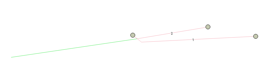
by , 6 weeks ago
| Attachment: | startTopo.png added |
|---|
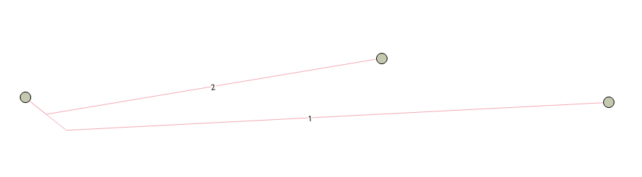
by , 6 weeks ago
| Attachment: | incomingLine.png added |
|---|
comment:3 by , 6 weeks ago
The initial state of the topology has only 2 edges being almost coincident in the segment incident to a shared node. Note how there is no node in the point in which they get far apart:

The incoming line has an endpoint near the spot in which we're missing a node

According to ST_Relate the incoming line has the same relation to both edges:
=# select ST_Relate(i.g,e.geom), ST_Crosses(i.g, e.geom), ST_Touches(i.g, e.geom), e.edge_id from t5699_offending_input i, topo_t5699.edge e;
 st_relate | st_crosses | st_touches | edge_id
-----------+------------+------------+---------
 FF10F0102 | f          | t          |       2
 FF10F0102 | f          | t          |       1
(2 rows)
The matrix is:
    i b e
    - - -
i | F F 1
b | 0 F 0
e | 1 0 2
What the matrix tells us is that the incoming line's endpoint intersects with the interiors of both edges, but if it is true that those two edges only intersect at their boundary how can their interior intersect both with the same point ? It sounds like a possible bug in GEOS to me.
ST_Relate finds one endpoint of the incoming segment being completely disjoint, as expected, and the other intersecting edge 2 but being disjoint from edge 1.
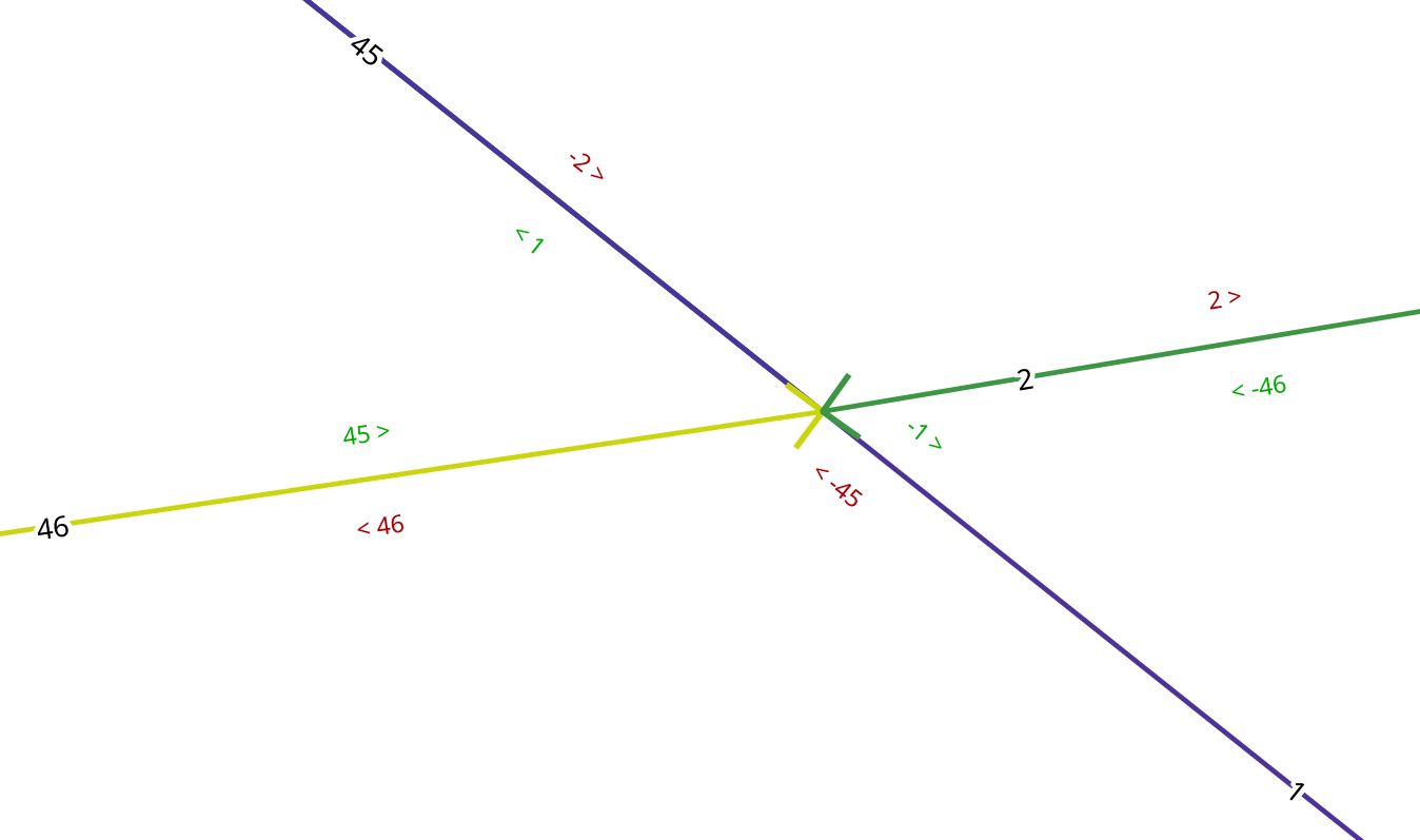
by , 6 weeks ago
| Attachment: | brokenEdgeLinking.png added |
|---|
comment:4 by , 6 weeks ago
Analyzing the resulting topology, reported as having crossing edges, I cannot get ST_Crosses nor ST_Relate to confirm the fact:
strk=# select * from validatetopology('topo_t5699');
       error       | id1 | id2
-------------------+-----+-----
 edge crosses edge |   1 |  46
(1 row)

strk=# select ST_Relate(e1.geom, e2.geom), ST_Crosses(e1.geom,e2.geom), st_touches(e1.geom, e2.geom) from topo_t5699.edge e1, topo_t5699.edge e2 where e2.edge_id > e1.edge_id;
 st_relate | st_crosses | st_touches
-----------+------------+------------
 FF1F00102 | f          | t
 FF1FF0102 | f          | f
 FF1F00102 | f          | t
 F01FF0102 | f          | t
 FF1F00102 | f          | t
 FF1F00102 | f          | t
(6 rows)
But I do see next_left and next_right labels being wron. Note how edges 1,2 and 45 have them wrong

comment:5 by , 6 weeks ago
Using squared distance, edge2 is confirmed being closer than edge1:
psql:break.sql:10: DEBUG:  [topo/lwgeom_topo.c:_lwt_AddPoint:5079] Edge 2 squared distance: 0
psql:break.sql:10: DEBUG:  [topo/lwgeom_topo.c:_lwt_AddPoint:5079] Edge 1 squared distance: 1.64235648202829e-31
psql:break.sql:10: DEBUG:  [topo/lwgeom_topo.c:_lwt_AddPoint:5110] Splitting edge 2
So what happens here is that edge 1 is indeed crossed by the incoming edge because the added node only splits edge 2 and leaves edge 1 untouched, with the result that noding in the topology breaks.
I believe the solution here would be to implement snapping of all edges upon inserting a new node, same as with https://trac.osgeo.org/postgis/ticket/5310#comment:3 - handling edges collapse as needed (the portions of edge1 and edge2 going from the new node to their shared node would be equal and thus need to be collapsed into one).
comment:6 by , 6 weeks ago
A probably more severe issue here is that we ALLOW an invalid topology to be created. This should supposedly not happen as the code is theoretically checking for all these invalid conditions before accepting the change.
The relevant snippt of the log is this:
sql:break.sql:10: DEBUG:  [topo/lwgeom_topo.c:_lwt_CheckEdgeCrossing:682] lwt_be_getEdgeWithinBox2D returned 3 edges
psql:break.sql:10: DEBUG:  [topo/lwgeom_topo.c:_lwt_CheckEdgeCrossing:713] Edge 5 converted to GEOS
psql:break.sql:10: DEBUG:  [topo/lwgeom_topo.c:_lwt_CheckEdgeCrossing:726] Edge 5 relate pattern is FF1F00102
psql:break.sql:10: DEBUG:  [topo/lwgeom_topo.c:_lwt_CheckEdgeCrossing:713] Edge 2 converted to GEOS
psql:break.sql:10: DEBUG:  [topo/lwgeom_topo.c:_lwt_CheckEdgeCrossing:726] Edge 2 relate pattern is FF1F00102
psql:break.sql:10: DEBUG:  [topo/lwgeom_topo.c:_lwt_CheckEdgeCrossing:713] Edge 1 converted to GEOS
psql:break.sql:10: DEBUG:  [topo/lwgeom_topo.c:_lwt_CheckEdgeCrossing:726] Edge 1 relate pattern is F01FF0102
psql:break.sql:10: DEBUG:  [topo/lwgeom_topo.c:_lwt_CheckEdgeCrossing:792] No edge crossing detected amongh the 3 candidate edges
The last edge (Edge 1) is clearly having the a boundary-interior intersection but the code is not considering that as problematic, while it IS, in this case.
follow-ups: 10 11 comment:7 by , 6 weeks ago
Raising an exception instead of silently creating an invalid topology is done in this PR: https://git.osgeo.org/gitea/postgis/postgis/pulls/195
With the code in that PR we now get, upon adding the final line:
ERROR: Spatial exception - geometry boundary touches interior of edge 1
This is still puzzling because the boundary of the geometry is supposed to be the same as the new node being created upon splitting edge 2, so if that boundary touches interior of edge 1 then also the added point should, but was found to be at a squared distance of 1.64235648202829e-31 units.
I suspect GEOS is internally reducing the precision of the geometries upon catching a topology error due to the same robustness troubles we are having.
comment:9 by , 6 weeks ago
The GEOS suspect is voiced here: https://lists.osgeo.org/pipermail/geos-devel/2024-March/011012.html
comment:10 by , 6 weeks ago
Replying to strk:
Raising an exception instead of silently creating an invalid topology is done in this PR: https://git.osgeo.org/gitea/postgis/postgis/pulls/195
With the code in that PR we now get, upon adding the final line:
ERROR: Spatial exception - geometry boundary touches interior of edge 1This is still puzzling because the boundary of the geometry is supposed to be the same as the new node being created upon splitting edge 2, so if that boundary touches interior of edge 1 then also the added point should, but was found to be at a squared distance of
1.64235648202829e-31units.I suspect GEOS is internally reducing the precision of the geometries upon catching a topology error due to the same robustness troubles we are having.
When the overlay NG code was added in JTS was not one intentions make spatial operations more robust and avoid Topology exceptions and I assume that may involve some kind off snapping ?
comment:11 by , 6 weeks ago
Replying to strk:
Raising an exception instead of silently creating an invalid topology is done in this PR: https://git.osgeo.org/gitea/postgis/postgis/pulls/195
Good, I tested this code last night then we have no invalid topologies any more.
comment:12 by , 6 weeks ago
Great to hear an exception helps avoiding the invalidity. I'd still keep the ticket open as it's still impossible to add a single-segment line into a valid topology.
See also #2038 for a similar case
comment:14 by , 5 weeks ago
An experimental code handling edge merges is here: https://git.osgeo.org/gitea/postgis/postgis/pulls/196
comment:15 by , 4 weeks ago
For the record, Dr.JTS confirmed the GEOS bug with RelateComputer: https://github.com/libgeos/geos/issues/968#issuecomment-2041134101
It's to be noted that fixing the GEOS bug would still not give us a solution to the problem of being able to load the incoming line into the existing topology.
File to run to prepare error context