
Opened 21 years ago
Closed 21 years ago
#366 closed defect (wontfix)
label backgrounds not always transparent
| Reported by: | Owned by: | warmerdam | |
|---|---|---|---|
| Priority: | high | Milestone: | |
| Component: | GDAL Support | Version: | 4.0 |
| Severity: | normal | Keywords: | |
| Cc: |
Description
From Frank:

The background areas in the transparent case are being used internally as
transparent, but for some reason the transparency is being burned into the
output raster when it should just let us see the layer underneath.

This seems like a bug in my RGBA handling in MapServer.

From Charlton:

Whenever I enable (STATUS ON) one of my layers that has a TRANSPARENCY value
associated w/ it, my labels go from having no background to having a white
background.  This is a problem since I don't want to use a black text on white
background.

Here are two samples.  The "good" one is how I would like the image to look
even w/ the transparent layer on.  The "bad" one is how it currently looks (w/
the transparent layer on).  Don't look for the transparent layer, though,
since I gave it a bogus expression to keep the image simple.

Any ideas?

Good image (w/o transparent layer on): http://caro-
coops.org/~cpurvis/misc/good_labels_no_trans.png

Bad image (w/ transparent layer on): http://caro-
coops.org/~cpurvis/misc/bad_labels_with_trans.png

  IMAGETYPE png
  OUTPUTFORMAT
    NAME png
    DRIVER "GD/PNG"
    MIMETYPE "image/png"
    IMAGEMODE RGBA
    EXTENSION "png"
    TRANSPARENT ON
  END
...
    CLASS
      NAME "streets_label"
      COLOR 0 0 0
      MAXSCALE 50000
      LABEL
        TYPE TRUETYPE
        FONT "arial-bold"
        SIZE 8
        POSITION AUTO
        ANGLE AUTO
        COLOR 255 255 0
      END
    END

I'm assuming that keeping TRANSPARENT ON w/i only the OUTPUTFORMAT block is
the right thing to do.

MS 3.7, gdal-1.1.8, gd-2.0.15
Attachments (4)
Change History (11)
comment:1 by , 21 years ago
| Summary: | legend backgrounds not always transparent → label backgrounds not always transparent |
|---|
comment:2 by , 21 years ago
| Status: | new → assigned |
|---|
comment:3 by , 21 years ago
I would add you should be able to run the test map by cd'ing into the directory and running "shp2img -m wrk.map -o out.png" possibly adding an appropriate path to the shp2img executable. If the given map works fine for you, please try to construct a similarly self contained example that demonstrates your problem.
by , 21 years ago
| Attachment: | wrk_with_shapefile.zip added |
|---|
test map w/ new shapefile and required data
comment:4 by , 21 years ago
If I replace my truetype label definition w/ a bitmap type, there is no problem.
comment:5 by , 21 years ago
Charlton, I have tried again to reproduce this with no success. I do not get the odd effects around the text with RGBA output and the sc_health partially transparent layer enabled. Could you attach what you get from shp2img? I think you will need to upgrade to MapServer from CVS. You mentioned earlier that the version was 3.7 which I assume is a not quite up to date with what is in CVS, right? There have been fixes in this area of functionality in recent months so it may already be fixed.
comment:6 by , 21 years ago
Bravo, Frank! Upgrading from 3.7dev to 4.0 did the trick. Thanks for all your help and troublshooting. (Don't know how you want to leave the bug status. I'll leave that in your hands.) Thanks again, Charlton
comment:7 by , 21 years ago
| Resolution: | → wontfix |
|---|---|
| Status: | assigned → closed |
Charlton, That's good news. I am not interested in digging around in 3.6.x since so I will just close it.
Note:
See TracTickets
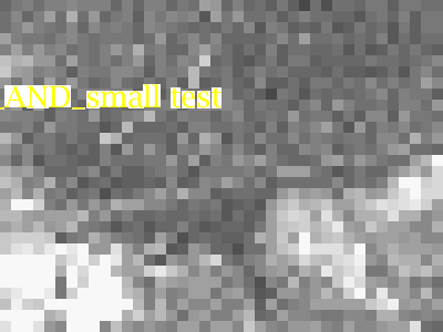
for help on using tickets.
OK, I have tried, but been unable to reproduce this so far.

I am using MapServer from CVS and a recent gd.

I put together this map file to test, basically a raster layer with one
label overlayed on it.  I have attached the mapfile and data files used in
my attempt.  I would appreciate your downloading the attachment and seeing
if you get the same output as I did with the mapfile, or if you get your
original problem.

#
# Tests labelling into an RGBA result.
#
# REQUIRES: SUPPORTS=FREETYPE OUTPUT=PNG
#
MAP
  NAME test
  IMAGETYPE png

  OUTPUTFORMAT
    NAME png
    DRIVER "GD/PNG"
    IMAGEMODE RGBA
    TRANSPARENT ON
  END

  SIZE 400 400
  SIZE 400 300
  EXTENT 0 0 400 300
  UNITS meters
  FONTSET fonts.lst

  SYMBOL
    NAME "circle"
    TYPE ellipse
    FILLED true
    POINTS 1 1 END
  END

  LAYER
    NAME fonttest
    TYPE POINT
    STATUS DEFAULT
    FEATURE
      POINTS 200 200 END
      TEXT "BIG_AND_small test"
    END
    CLASS
       COLOR 0 0 0
       LABEL
        COLOR 255 255 0
        FONT lucida
        POSITION AUTO
        ANGLE AUTO
        TYPE truetype
        SIZE 20
      END
    END # CLASS
  END

LAYER
  NAME grey
  TYPE raster
  STATUS default
  DATA pct22.tif
END
END