
Opened 15 years ago
Closed 14 years ago
#3013 closed defect (invalid)
Labels don't always show
| Reported by: | adube | Owned by: | aboudreault |
|---|---|---|---|
| Priority: | normal | Milestone: | 6.0 release |
| Component: | MapServer C Library | Version: | 5.4 |
| Severity: | normal | Keywords: | labels |
| Cc: | tbonfort, dmorissette, sdlime |
Description
I'm trying to show as much street labels as possible using buffer 0 and minfeaturesize 1 to have as much labels displayed as possible. The result returned seems to miss a lot of labels.
I'll attach an example in a couple of minutes and report back.
Attachments (2)
Change History (11)
comment:1 by , 15 years ago
comment:2 by , 15 years ago
| Cc: | added |
|---|
comment:3 by , 15 years ago
| Milestone: | → 5.4.1 release |
|---|---|
| Status: | new → assigned |
comment:4 by , 14 years ago
| Cc: | added; removed |
|---|---|
| Milestone: | 5.6 release → 6.0 release |
| Owner: | changed from to |
| Status: | assigned → new |
Alan, Alexandre, is this ticket still relevant? If yes then it should be fixed in 6.0
by , 14 years ago
| Attachment: | merged-road.gif added |
|---|
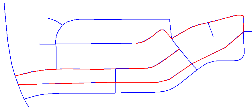
Snapshot from QGIS. The red road is a MERGED MultiLineString feature. It could be a hint.
comment:5 by , 14 years ago
Yes, I still think the labels should have been shown, at least on the left (check description above).
I'm not sure about the center (see the merged-road.gif). The fact that no label is shown may be because of the data.
comment:6 by , 14 years ago
I haven't tested this issue with MapServer 5.6 yet. As soon as I do, I'll let you know if this ticket is still relevant.
comment:7 by , 14 years ago
adube, are you still able to test this ticket quickly with svn trunk? Otherwise, I'll setup something here to do so...
comment:8 by , 14 years ago
The reason why the road Cypress Creek Way (the perpendicular road with Washington Ferry Rd) is simply that the text length is too long. It is more than 1.5*line_length. This case is very similar to the road William Wood Ct. The reason why William Wood Ct is displayed is because this feature is composed of only 2 points, so it is drawed using the the LabelPoint algorithm, compared to Cypress Creek Way, which is more than 2 points and drawn with the LabelPath algo. The LabelPoint algo is not aware of the text length. I don't think it's a bug then.. comments ?
comment:9 by , 14 years ago
| Resolution: | → invalid |
|---|---|
| Status: | new → closed |
Closing this ticket, reopen it it needed.
Here's a live example of the problem :
http://dev4.mapgears.com/cgi-bin/mapserv?map=/home/mapgears/proj/msbug/3013/tiger.map&map_imagetype=palette&mode=map&mapext=-86.47009580577442+32.44186405960697+-86.45295198465901+32.45257894780411&imgext=-86.47009580577442+32.44186405960697+-86.45295198465901+32.45257894780411&map_size=900+562&imgx=450&imgy=281&imgxy=900+562
It seems that there is plenty of space to display roads right in the center. Also, on the left, there a small perpendicular road Washington Ferry Rd that has no label but there's plenty of space to have one.
As I said, the label options have :