Opened 9 years ago
Closed 5 years ago
#5981 closed defect (wontfix)
gdalwarp -crop_to_cutline not taking blend distance into account
| Reported by: | maphew | Owned by: | warmerdam |
|---|---|---|---|
| Priority: | normal | Milestone: | closed_because_of_github_migration |
| Component: | default | Version: | 1.11.2 |
| Severity: | normal | Keywords: | gdalwarp, cutline |
| Cc: |
Description (last modified by )
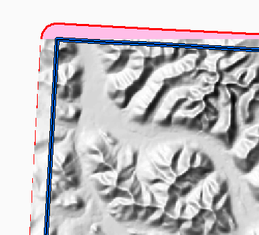
...when using a blend distance the left* side of the corners are not blended. In attached screenshot blue line is clipping polygon, red line with pink fill is expected resulting image extent (source image is not shown, it extends well beyond visible portion of screen).
Raster is in EPSG:3579, shapefile is "Yukon_Albers" (which is identical to EPSG:3578, but has a different name), and both coordsys are nearly identical.
If helpful I can upload sample data (~2mb).
* from viewpoint of standing at corner looking to center
> cmd /version
Microsoft Windows [Version 6.1.7601]
Copyright (c) 2009 Microsoft Corporation.  All rights reserved.
Clink v0.4.4 [git:a60c0a] Copyright (c) 2014 Martin Ridgers
http://mridgers.github.io/clink

> gdalwarp --version
GDAL 1.11.2, released 2015/02/10

> gdalwarp -cutline \p\ytdemv3\source\nts_index_250k.shp ^
-cwhere "'TILE_NAME' = '106D'" -cblend 15 -crop_to_cutline ^
dem_100m_shade.tif cropped_15.tif
...update: confirming that if -crop_to_cutline option is not used, the the raster is cropped as expected, albeit with a large nodata surround.
Attachments (2)
Change History (5)
by , 9 years ago
| Attachment: | 2015-06-01 10_30_33-Select AOI.mxd - ArcMap.png added |
|---|
by , 9 years ago
| Attachment: | 2015-06-01 10_47_28-Select AOI.mxd - ArcMap.png added |
|---|
closeup of top left corner
comment:1 by , 9 years ago
| Description: | modified (diff) |
|---|
comment:2 by , 9 years ago
| Description: | modified (diff) |
|---|---|
| Summary: | gdalwarp -cutline not taking blend distance into account → gdalwarp -crop_to_cutline not taking blend distance into account |
Ahhh,
comment:3 by , 5 years ago
| Milestone: | → closed_because_of_github_migration |
|---|---|
| Resolution: | → wontfix |
| Status: | new → closed |
This ticket has been automatically closed because Trac is no longer used for GDAL bug tracking, since the project has migrated to GitHub. If you believe this ticket is still valid, you may file it to https://github.com/OSGeo/gdal/issues if it is not already reported there.
screenshot showing clipped raster, clipping polygon, and expected extent