#1157 closed bug (fixed)
incorrect loading and band management of 2-band rasters
| Reported by: | gislab | Owned by: | ersts |
|---|---|---|---|
| Priority: | major: does not work as expected | Milestone: | |
| Component: | Rasters | Version: | Trunk |
| Keywords: | Cc: | ||
| Must Fix for Release: | Yes | Platform: | All |
| Platform Version: | Awaiting user input: | no |
Description
- On load, 2 band raster doesn't show up (should've load 2-1-1 or 2-2-1 on default? btw; having setting for band order to load on default will make work with multiple images so much easier).
- After changing band order in raster properties it shows up (band names show up as grey and undefined, I suppose band 1 and band 2 will be more straightforward).
but
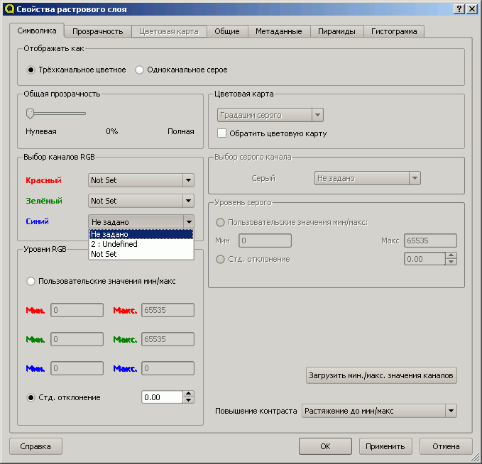
- Band selectors in raster properties act weird, try this:
- add 2-band raster to qgis
- go to layer properties, band selectors
- click on the third one (blue) - only "2: undefined" and "not set" shows up, why not "1: gray" also?
I can provide an example raster if needed.
Attachments (3)
Change History (12)
by , 16 years ago
| Attachment: | translation.gif added |
|---|
by , 16 years ago
| Attachment: | subset.zip added |
|---|
comment:1 by , 16 years ago
comment:2 by , 16 years ago
| Milestone: | Version 0.11.0 → Version 1.0.0 |
|---|---|
| Owner: | changed from to |
comment:3 by , 16 years ago
| Must Fix for Release: | No → Yes |
|---|---|
| Platform: | Windows → All |
| Priority: | minor: annoyance or enhancement → major: does not work as expected |
| Type: | defect → bug |
| Version: | 0.10.0 → HEAD |
I confirm the issue in 0.11 on GNU/Linux as well. In general - multiband imagery with 2 bands only are displayed blank. In raster properties only RED and GREEN are assigned - one needs to manually choose the BLUE band from the 2 available to see anything.
However, the issue III from the orginal bug report is gone now.
follow-up: 5 comment:4 by , 16 years ago
Providing an example would be great!
This happens because if any channel is set to "No Set" the rending process is actually totally skipped.
Defaulting to 122/RGB would be very simple. But in my mind the question is, is it more appropriate automatically display 2-band images as gray scale images rather than RBG?
I personally have never had the need for a 2-band image, and cannot come up with a situation where one would be needed, let alone displaying them in color. Can you provide a short description of how you are using these 2-band data?
Thanks!
follow-up: 6 comment:5 by , 16 years ago
Replying to ersts:
Providing an example would be great!
There is, attached to the ticket.
I personally have never had the need for a 2-band image, and cannot come up with a situation where one would be needed, let alone displaying them in color.
I can't speak for the report's author, but as to me - since QGIS allows to load such data, it should handle them somehow, shouldn't it?
comment:6 by , 16 years ago
Replying to msieczka:
Replying to ersts:
Providing an example would be great!
There is, attached to the ticket.
Yes, so there is, looked at the screen shot but not the other file.
I personally have never had the need for a 2-band image, and cannot come up with a situation where one would be needed, let alone displaying them in color.
I can't speak for the report's author, but as to me - since QGIS allows to load such data, it should handle them somehow, shouldn't it?
Sure it should! Looking at the example image, I think it would be better to load this as gray scale rather than force 122/RGB.
comment:7 by , 16 years ago
Hi, I'm glad this received some attention. Ability to work with 2-band rasters in RGB mode is as important as with normal 3-band rasters, as this helps visual interpretation.
Just to give you an example. I'm working with lots of MODIS data which has 2 bands of 250 m (and some others, but only 2 with this res), I have the whole production system based on such composites created from these bands and I do want to see them in color even though one of the band is "missing".
I've attached an example of what it would look like (2-1-1), if I have an ability to put 2nd (infrared) band in R-gun and 1st in G and B. I have rather convenient (I'd even say traditional) way to visualize (i.e. vegetation is red as it supposed to be).
by , 16 years ago
| Attachment: | vizual.gif added |
|---|
comment:8 by , 16 years ago
| Resolution: | → fixed |
|---|---|
| Status: | new → closed |
Band names will be generic from now on to avoid confusion.
I also added an ability to set the default band combinations which will be persistent between QGIS sessions
translation.gif - also regarding III, changing the bands in the band selector sometimes lead to totally weird results, on the attachement, notice blue band band selector, first item - translated, second - "2: undefined", third - not translated