I've been able to grag a series of images that better
highlight what is going on with this situation.
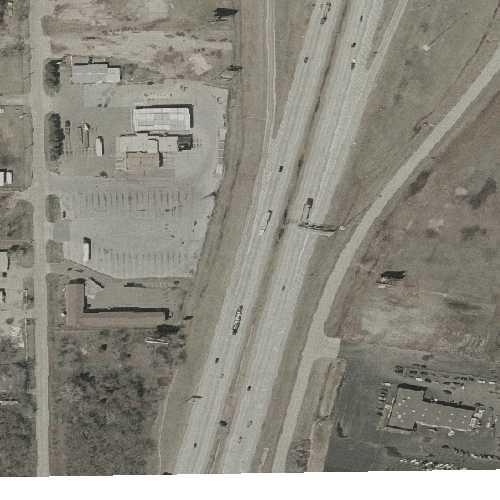
13.jpg: This is the result of the following WMS request
(grabber by sniffing traffic) by Mapserver in a browser saved to disk.
http://gisdata.usgs.net/servlet/com.esri.wms.Esrimap?SERVICENA
ME=133urban&REASPECT=true&REQUEST=map&SERVICE=WMS&WMTVER=1.0.0
&LAYERS=UA%5FORTHO%5F302%5F01&FORMAT=png&TRANSPARENT=TRUE&STYL
ES=&REQUEST=map&WIDTH=500&HEIGHT=500&SRS=EPSG:4326&BBOX=-97.45
9393,35.545685,-97.455491,35.548877&EXCEPTIONS=INIMAGE%20HTTP/1.1
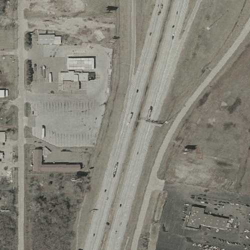
12.jpg: This is mapserver's output that generated the above
request. The mapfile Gayathri already attached.
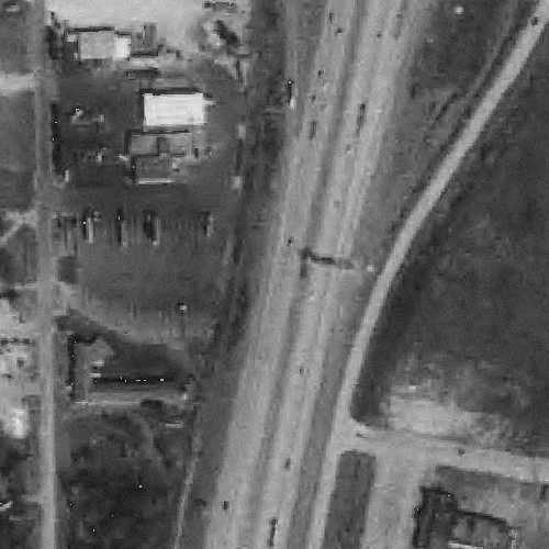
14.jpg: This is mapserver's output for the same extent from
our Alber's projected DOQQs.
It seems as though Mapserver is expanding the BBOX in order
to get enough result to cover the view extent after
reprojection - because there is a larger area covered by
13.jpgthen by 14.jpg. But, it seems like after reprojection,
mapserver is not taking into account that it got more then it
needed when it compiles the final output. Does this sound right?
What more information could we provide so people that really
know what is going on here can help?
Thanks,
Dave Lowther
>
> > -----Original Message-----
> > From: Swaminathan, Gayathri [mailto:gayathri@ou.edu]
> > Sent: Monday, September 29, 2003 8:59 AM
> > To: 'Ed McNierney'
> > Cc: Mapserver List (mapserver-users@lists.gis.umn.edu)
> > Subject: RE: [Mapserver-users] Max image size
> >
> >
> > Ed,
> >
> > Is there a way to log the WMS requests?
> >
> > Also I missed to include the site address this is happening in my
> > last mail.
> >
> > It is http://129.15.172.20/okstatedemo40.htm
> >
> > If you zoom into Oklahoma city area( the center of the state) and
> > keep zooming in., you will see the white line behavior after a
> > certain scale.
> >
> > Thanks for all your help and time on this.
> > ~Gayathri
> >
> > -----Original Message-----
> > From: Ed McNierney [mailto:ed@topozone.com]
> > Sent: Friday, September 26, 2003 4:40 PM
> > To: Swaminathan, Gayathri
> > Subject: RE: [Mapserver-users] Max image size
> >
> >
> > Gayathri -
> >
> > I'm always a little worried when the Metadata document describes the
> > imagery as UTM NAD83 and the Capabilities document declares it to be
> > geographic!
> >
> > Have you tried simply pulling up some images in a Web browser with
> > hand-coded WMS requests? That ought to give you a better sense of
> > what the data's really doing.
> >
> > - Ed
> >
> > Ed McNierney
> > President and Chief Mapmaker
> > TopoZone.com / Maps a la carte, Inc.
> > 73 Princeton Street, Suite 305
> > North Chelmsford, MA 01863
> > ed@topozone.com
> > (978) 251-4242
> >
> > -----Original Message-----
> > From: Swaminathan, Gayathri [mailto:gayathri@ou.edu]
> > Sent: Friday, September 26, 2003 5:02 PM
> > To: 'Frank Warmerdam'; mapserver-users@lists.gis.umn.edu
> > Subject: RE: [Mapserver-users] Max image size
> >
> >
> > Hi:
> >
> > I am trying to project the USGS urban orthos at
> > http://gisdata.usgs.net/mapservices.asp?CategoryName=Orthoimag
> > ery using mapserver version 4.
> >
> > My map projection is in America Albers Equal Area Conic
> >
> > And the WMS layer request is in WGS 84.
> >
> > The initial hurdle of the map image getting squished was overcome
> > with the help of Brian's advice to do REASPECT=false at the end of
> > the request string.
> >
> > But there is a white band that still appears after zooming in over a
> > certain scale.
> >
> > We are not sure if this is a WGS84->Albers problem or else.
> >
> > Has anyone else come across this problem? We really love albers
> > projection for the map.
> >
> > Thanks,
> > Gayathri
> >
> >
> > The map file looks like below:
> >
> > #
> > # Start of map file
> > #
> > MAP
> > NAME OKSTATE40
> > STATUS ON
> > SIZE 500 400
> > EXTENT -633771.227805 1060738.573036 152927.340425 1689379.870746
> > #EXTENT -665000 -707000 163000 -227000 UNITS METERS
> > #EXTENT -102 33 -94 37
> > #UNITS DD
> > SHAPEPATH "../data"
> > FONTSET fonts.list
> > #IMAGECOLOR 255 255 255
> > IMAGECOLOR 206 208 214
> > INTERLACE ON
> > SYMBOLSET "symbolset.list"
> >
> > OUTPUTFORMAT
> > NAME png
> > DRIVER "GD/PNG"
> > MIMETYPE "image/png"
> > IMAGEMODE RGB
> > EXTENSION "png"
> > END
> >
> >
> >
> > PROJECTION # ALBERS OK -all drg's and doqq's on geo site
> are OK ALBERS
> > proj=aea
> > lat_1=29.500000000 #SP1
> > lat_2=45.500000000 #SP2
> > lat_0=23.000000000 #REF LAT
> > lon_0=-96.000000000 #CENTRAL MERIDIAN
> > x_0=0.000 #FALSE EAST
> > y_0=0.000 # FALSE NORTH
> > datum=NAD83
> > ellps=GRS80
> > no_defs
> > END
> >
> > WEB
> > EMPTY
> > "http://129.15.172.20/geomap/OKSTATE40/mapOKSTATE40norecords.h
> tm"
>
> ...... And so on....
>
> ### OKC 2002 Ortho USGS-WMS ###
> LAYER
> NAME Urban133
> GROUP Imagery
> TYPE RASTER
> STATUS ON
> MAXSCALE 500000
> OFFSITE 255 255 255
> CONNECTIONTYPE WMS
> CONNECTION
> "http://gisdata.usgs.net:80/servlet/com.esri.wms.Esrimap?SERVI
CENAME=133urba
n&REASPECT=true&REQUEST=map"
#MINSCALE 500
PROJECTION
"init=epsg:4326" #WGS 84
END
TRANSPARENCY 20
METADATA
"NoID" "T"
"wms_name" "UA_ORTHO_302_01"
"wms_server_version" "1.0.0"
"wms_format" "png"
"wms_title" "USGS Urban Color Ortho 2002"
"wms_group_title" "Imagery"
"wms_style" ""
"wms_extent" "-123.12987 45.241726 -122.3584 45.75648"
END
END
_______________________________________________
Mapserver-users mailing list
Mapserver-users@lists.gis.umn.edu
http://lists.gis.umn.edu/mailman/listinfo/mapserver-users
_______________________________________________
Mapserver-users mailing list
Mapserver-users@lists.gis.umn.edu
http://lists.gis.umn.edu/mailman/listinfo/mapserver-users

12.jpg