
| Version 8 (modified by , 18 years ago) ( diff ) |
|---|
MapGuide RFC 16 - Elevation and Extrusion Support for KML 
This page contains a change request (RFC) for the MapGuide Open Source project. More MapGuide RFCs can be found on the RFCs page.
Status 
| RFC Template Version | (1.0) |
| Submission Date | (Date/Time submitted) |
| Last Modified | Chris ClaydonTimestamp |
| Author | Chris Claydon |
| RFC Status | draft |
| Implementation Status | pending |
| Proposed Milestone | 1.2 |
| Assigned PSC guide(s) | |
| Voting History | (vote date) |
| +1 | |
| +0 | |
| -0 | |
| -1 |
Overview 
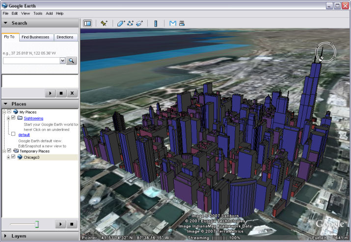
The purpose of this RFC is to allow MapGuide users to configure elevation and extrusion parameters in a layer definition, and to use those settings to extrude features vertically in the KML generated for consumption by Google Earth. This provides a highly compelling way to visualize spatial data that contains a vertical component.
Motivation 
MapGuide currently supports 2D representation of spatial data. However, many spatial data sets contain height information for the features they contain, giving the potential for 2.5D representation. This RFC describes how the MapGuide Layer Definition schema can be extended to specify expressions to be used to calculate a base elevation and extrusion size. Support for 2.5D would initially be implemented by the KML service, allowing visualization of solid objects in Google Earth. An example of the potential output is shown below:

Proposed Solution 
The proposed solution contains modifications to: the layer definition XML schema, the MDF Model, the MDF Parser, the KML Service, and the Rendering/Stylization project.
Layer Definition Schema Changes 
The layer definition schema contains numerous !ExtendedData1 elements that allow the schema to be extended without breaking forward or backward compatibility. The changes proposed in this RFC would initially be added into one of these elements, and would eventually be moved to the main part of the schema whenever the next schema version update is carried out. See MapGuide RFC 10 for more details.
<xs:complexType name="VectorScaleRangeType">
<xs:sequence>
<xs:element name="MinScale" type="xs:double" minOccurs="0">... <xs:element name="MaxScale" type="xs:double" minOccurs="0">... <xs:choice minOccurs="0" maxOccurs="unbounded">
<xs:element name="AreaTypeStyle" type="AreaTypeStyleType">... <xs:element name="LineTypeStyle" type="LineTypeStyleType">... <xs:element name="PointTypeStyle" type="PointTypeStyleType">...
</xs:choice> <xs:element name="ExtendedData1" minOccurs="0" >
<xs:complexType>
<xs:sequence>
<xs:element name="ElevationSettings" type="ElevationSettingsType" minOccurs="0" /> <xs:element name="ExtendedData2" type="ExtendedDataType" minOccurs="0" />
</xs:sequence>
</xs:complexType>
</xs:element>
</xs:sequence>
</xs:complexType> <xs:complexType name="ElevationSettingsType">
<xs:sequence>
<xs:element name="ZOffset" type="xs:string" minOccurs="0" /> <xs:element name="ZExtrusion" type="xs:string" minOccurs="0" /> <xs:element name="ZOffsetType" type="ElevationTypeType" minOccurs="0" /> <xs:element name="ExtendedData1" type="ExtendedDataType" minOccurs="0" />
</xs:sequence>
</xs:complexType> <xs:simpleType name="ElevationTypeType">
<xs:annotation>
<xs:documentation>The possible interpretations of a ZOffset value.</xs:documentation>
</xs:annotation> <xs:restriction base="xs:string">
<xs:enumeration value="RelativeToGround"/> <xs:enumeration value="Absolute"/>
</xs:restriction>
</xs:simpleType>
Implications 
This section allows discussion of the repercussions of the change, such as whether there will be any breakage in backwards compatibility, if documentation will need to be updated, etc.
Test Plan 
How the proposed change will be tested, if applicable. New unit tests should be detailed here???
Funding/Resources 
This section will confirm that the proposed feature has enough support to proceed. This would typically mean that the entity making the changes would put forward the RFC, but a non-developer could act as an RFC author if they are sure they have the funding to cover the change.
Attachments (1)
-
KmlExtrusionScreenshot.jpg
(92.5 KB
) - added by 18 years ago.
Screenshot of KML with extrusion in Google Earth
Download all attachments as: .zip