
| Version 6 (modified by , 6 years ago) ( diff ) |
|---|
GRASS GIS 7.4.1
DRAFT ONLY!
Table of Contents
A short summary of changes: New features in GRASS 7.4
Releases
Stable Release
Release date: XX May 2018Announcement: https://grass.osgeo.org/news/71/15/GRASS-GIS-7-4-1-released/Changelog: https://grass.osgeo.org/grass74/source/ChangeLog_7.4.1.gz- Binaries: https://grass.osgeo.org/download/software/#g74x
Source code: https://grass.osgeo.org/grass74/source/grass-7.4.1.tar.gz (md5sum)SVN Source Code Checkout 7.4.1:svn checkout https://svn.osgeo.org/grass/grass/tags/release_201805XX_grass_7_4_1
Release Candidate 2 (RC2)
Release date: XX Apr 2018Changelog: https://grass.osgeo.org/grass74/source/ChangeLog_7.4.1RC2.gz- Binaries: https://grass.osgeo.org/download/software/#g74x
Source code: https://grass.osgeo.org/grass74/source/grass-7.4.1RC2.tar.gz (md5sum)SVN Source Code Checkout 7.4.1RC2:svn checkout https://svn.osgeo.org/grass/grass/tags/release_201804XX_grass_7_4_1RC2
Release Candidate 1 (RC1)
Release date: XX Apr 2018Changelog: https://grass.osgeo.org/grass74/source/ChangeLog_7.4.1RC1.gz- Binaries: https://grass.osgeo.org/download/software/#g74x
Source code: https://grass.osgeo.org/grass74/source/grass-7.4.1RC1.tar.gz (md5sum)SVN Source Code Checkout 7.4.1RC1:svn checkout https://svn.osgeo.org/grass/grass/tags/release_201804XX_grass_7_4_1RC1
SVN Source Code
- Milestone: 7.4.1
- SVN Checkout latest 7.4 release branch (including yet unpublished bugfixes):
svn checkout https://svn.osgeo.org/grass/grass/branches/releasebranch_7_4
Overview of changes
A series of new features and stability fixes, manual improvements, and a few language translations have been added.
The GRASS GIS 7.4.1 release provides more than XXX fixes and improvements with respect to the stable release 7.4.0.
New modules
Major module changes
(see also below for closed bugs)
Minor module changes
(see also below for closed bugs)
Improvements in the Graphical User Interface
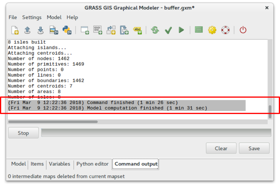
- Graphical Modeler: print computational time elapsed

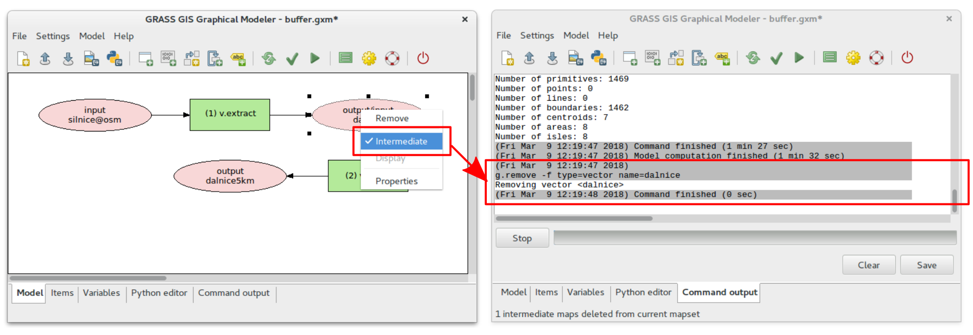
- Graphical Modeler: delete intermediate data when computation finished

Scripting
Projection support
Library changes
User Manuals - Documentation
Message Translations
New Addons since GRASS 7.4.0
Closed tickets
Closed bugs since the last release
- #2790
- Output of t.rast.list with method=comma and columns=name does not differ from output with columns=id
- #3059
- r.external.out does not write CRS information
- #3151
- raster digitizer crashes GUI in trunk
- #3223
- r.info displays wrong timestamp after t.rast.series with a where clause
- #3332
- v.proj - Error in pj_do_transform
- #3344
- r.stream.slope Segmentation fault: 11 error
- #3450
- 7.4.0 new modules missing in GUI menus
- #3469
- i.atcorr: Sentinel-2 support broken on some systems
- #3484
- Patch to fix spelling errors
- #3488
- v.in.ogr mangeling of column names when imporing OSM geojson extracts
- #3492
- r.texture overwrites without --o flag and without any warning when map exists
- #3493
- Compilation error with python 2.6
- #3496
- v.in.pdal: does not compile with PDAL 1.6.0
- #3505
- Opening a workspace file
- #3514
- Read EPSG codes with PROJ v.5 fails
- #3536
- python library db_table_in_vector function
- #3542
- cannot set default font in preferences
- #3546
- t.rast.what: issues in one_point_per_col_output()
- #3557
- Patch to fix spelling errors
- #3567
- v.select: doubtful result with the default overlap operator selecting areas with lines
Closed wishes since the last release
- #789
- g.region option to expand the computational region of about "some" pixels?
- #1878
- Metric distance option for v.distance in latlon regions
- #2122
- v.to.db: new variables to add
- #2183
- v.centerpoint: category values in ascii output should include original cat values
- #2234
- wxGUI d.mon and g.gui monitor rendering is slow
- #2368
- Python version of r.grow does not support shrinking
- #2417
- r.profile should report distance in location units
- #2896
- Allow installation of specific versions of GRASS addons
- #3416
- t.list: add mapset option as in g.list
- #3482
- i.atcorr: Add Sentinel-2B
- #3511
- [patch] v.buffer: allow squared buffers around points
Attachments (4)
-
grass-modeler-finished-new.png
(134.3 KB
) - added by 6 years ago.
wxGUI Graphical Modeler: print computational time elapsed
-
grass-modeler-intermediate-data-new.png
(257.7 KB
) - added by 6 years ago.
wxGUI Graphical Modeler: delete intermediate data when computation finished
-
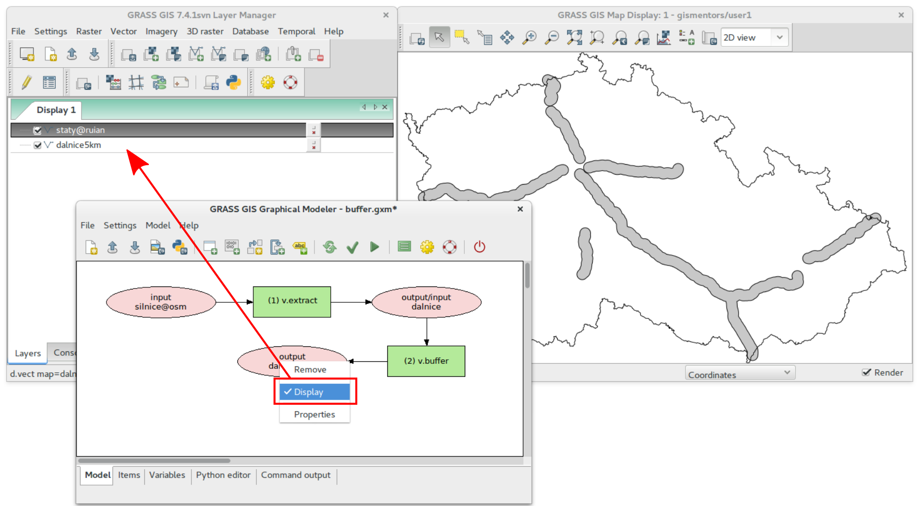
grass-modeler-display-data-new.png
(343.5 KB
) - added by 6 years ago.
wxGUI Graphical Modeler: mark data to be displayed
-
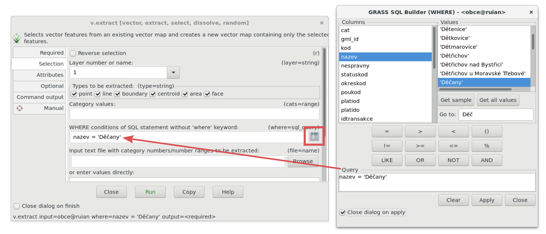
wxgui-sqlwhere-select.png
(289.3 KB
) - added by 6 years ago.
SQL Where Select Widget
Download all attachments as: .zip
Note:
See TracWiki
for help on using the wiki.