
| Version 23 (modified by , 6 years ago) ( diff ) |
|---|
GRASS GIS 7.4.1
DRAFT ONLY!
Table of Contents
A short summary of changes: New features in GRASS 7.4
Releases
Stable Release
Release date: XX May 2018Announcement: https://grass.osgeo.org/news/71/15/GRASS-GIS-7-4-1-released/Changelog: https://grass.osgeo.org/grass74/source/ChangeLog_7.4.1.gz- Binaries: https://grass.osgeo.org/download/software/#g74x
Source code: https://grass.osgeo.org/grass74/source/grass-7.4.1.tar.gz (md5sum)SVN Source Code Checkout 7.4.1:svn checkout https://svn.osgeo.org/grass/grass/tags/release_201805XX_grass_7_4_1
Release Candidate 2 (RC2)
Release date: XX Apr 2018Changelog: https://grass.osgeo.org/grass74/source/ChangeLog_7.4.1RC2.gz- Binaries: https://grass.osgeo.org/download/software/#g74x
Source code: https://grass.osgeo.org/grass74/source/grass-7.4.1RC2.tar.gz (md5sum)SVN Source Code Checkout 7.4.1RC2:svn checkout https://svn.osgeo.org/grass/grass/tags/release_201804XX_grass_7_4_1RC2
Release Candidate 1 (RC1)
- Release date: 4 May 2018
- Changelog: https://grass.osgeo.org/grass74/source/ChangeLog_7.4.1RC1.gz
- Binaries: https://grass.osgeo.org/download/software/#g74x
- Source code: https://grass.osgeo.org/grass74/source/grass-7.4.1RC1.tar.gz (md5sum)
- SVN Source Code Checkout 7.4.1RC1:
svn checkout https://svn.osgeo.org/grass/grass/tags/release_20180504_grass_7_4_1RC1
SVN Source Code
- Milestone: 7.4.1
- SVN Checkout latest 7.4 release branch (including yet unpublished bugfixes):
svn checkout https://svn.osgeo.org/grass/grass/branches/releasebranch_7_4
Overview of changes
A series of new features and stability fixes, manual improvements, and a few language translations have been added.
The GRASS GIS 7.4.1 release provides more than 100 fixes and improvements with respect to the stable release 7.4.0.
New modules
Major module changes
(see also below for closed bugs)
- G74:i.atcorr: sync to trunk (updated spectral curves for various satellites; fix band order for Worldview2; addition of Sentinel-2B, improvement of numerical stability
- G74:v.in.pdal: change API calls to PDAL 1.6.0, see #3496 and #2732
Minor module changes
(see also below for closed bugs)
- raster and vector export (G74:r.out.gdal, G74:r.external.out, G74:v.out.ogr, G74:v.external.out) now includes the CRS EPSG code if available
- G74:r.cross: create categories for output value 0, it is a valid result
- G74:r.contour: avoid tracing back of contour lines
- G74:r.import: use auto-adjustment for lat/lon
- G74:r.in.gdal: fix column offset and column mapping when limiting import to the current region
- G74:r.in.gdal: print only proj comparision when -j flag is given (r.in.gdal -j is mostly used in scripts)
- G74:r.texture: Fatal error if one of the requested output maps exists
- G74:t.info: activate -h flag
- G74:t.rast.series: Fixed bug #3223 wrong time stamp for raster map in case where condition was used
- G74:v.db.dropcolumn: preserve field length for field type CHARACTER
- G74:v.in.ogr: fix duplicate column names
- G74:v.out.ogr: create and write a new feature only once to avoid duplicate FID's which resulted in an incomplete export in some cases for some output formats, e.g. GPKG.
- G74:v.random restrict wrong categories assigned, see #3524
Improvements in the Graphical User Interface
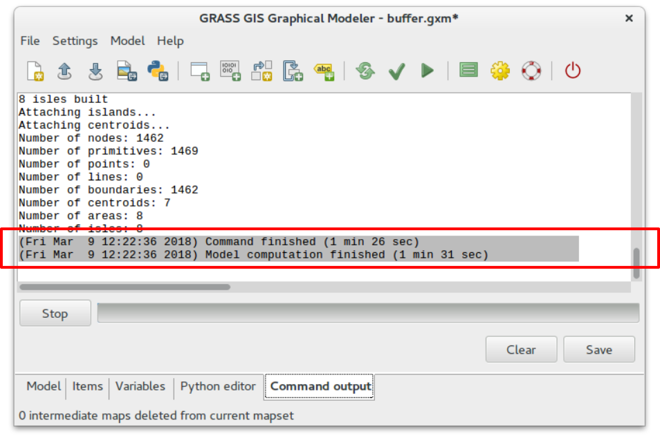
- Graphical Modeler: print computational time elapsed

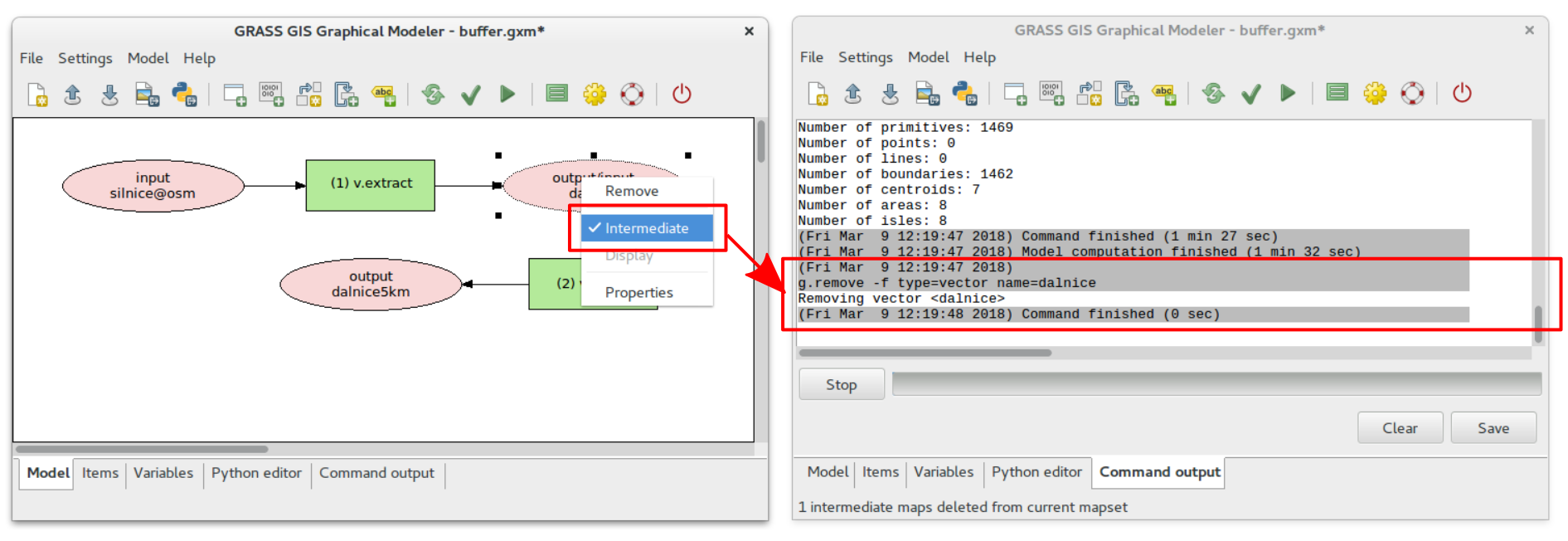
- Graphical Modeler: delete intermediate data when computation finished

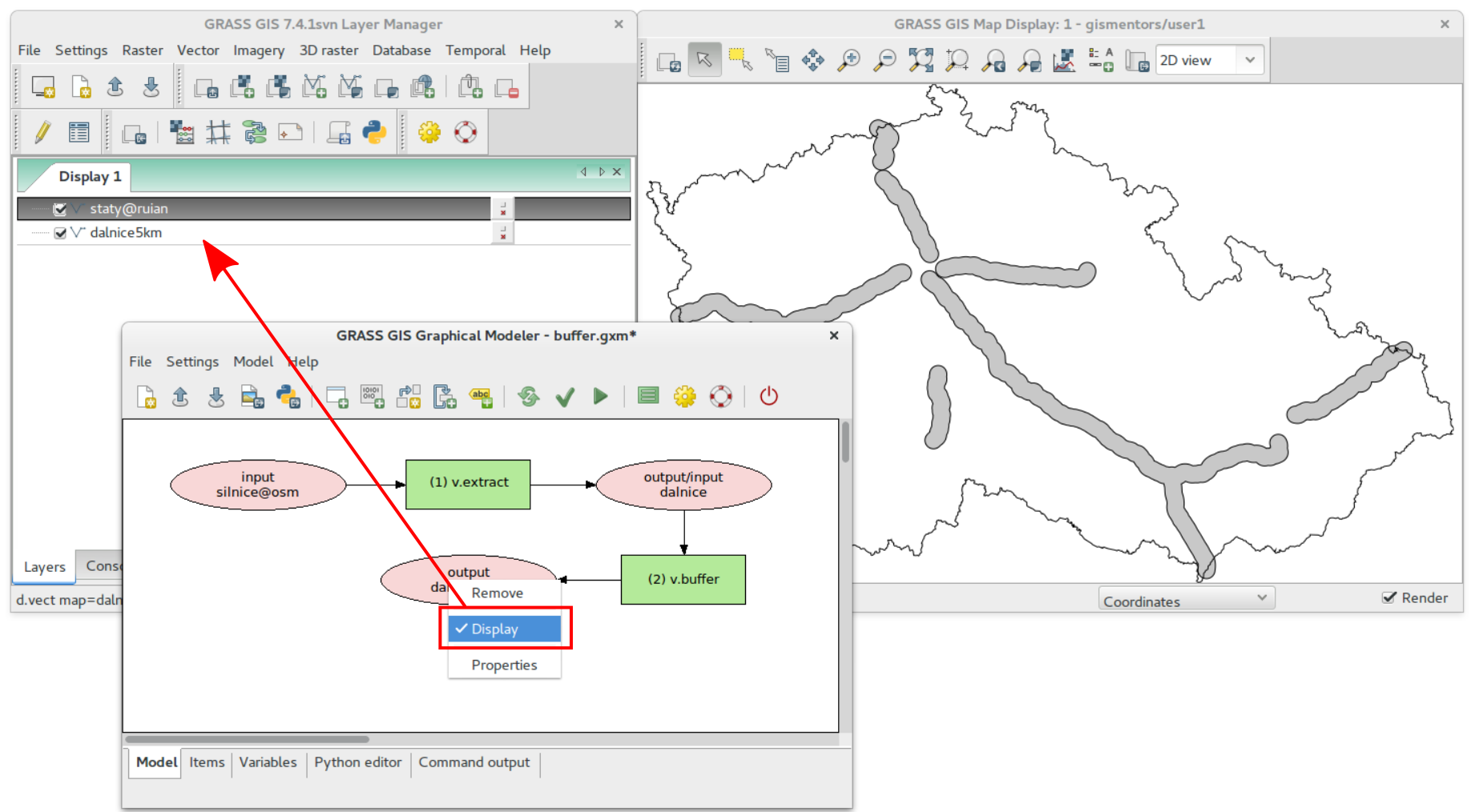
- Graphical Modeler: mark data to be displayed

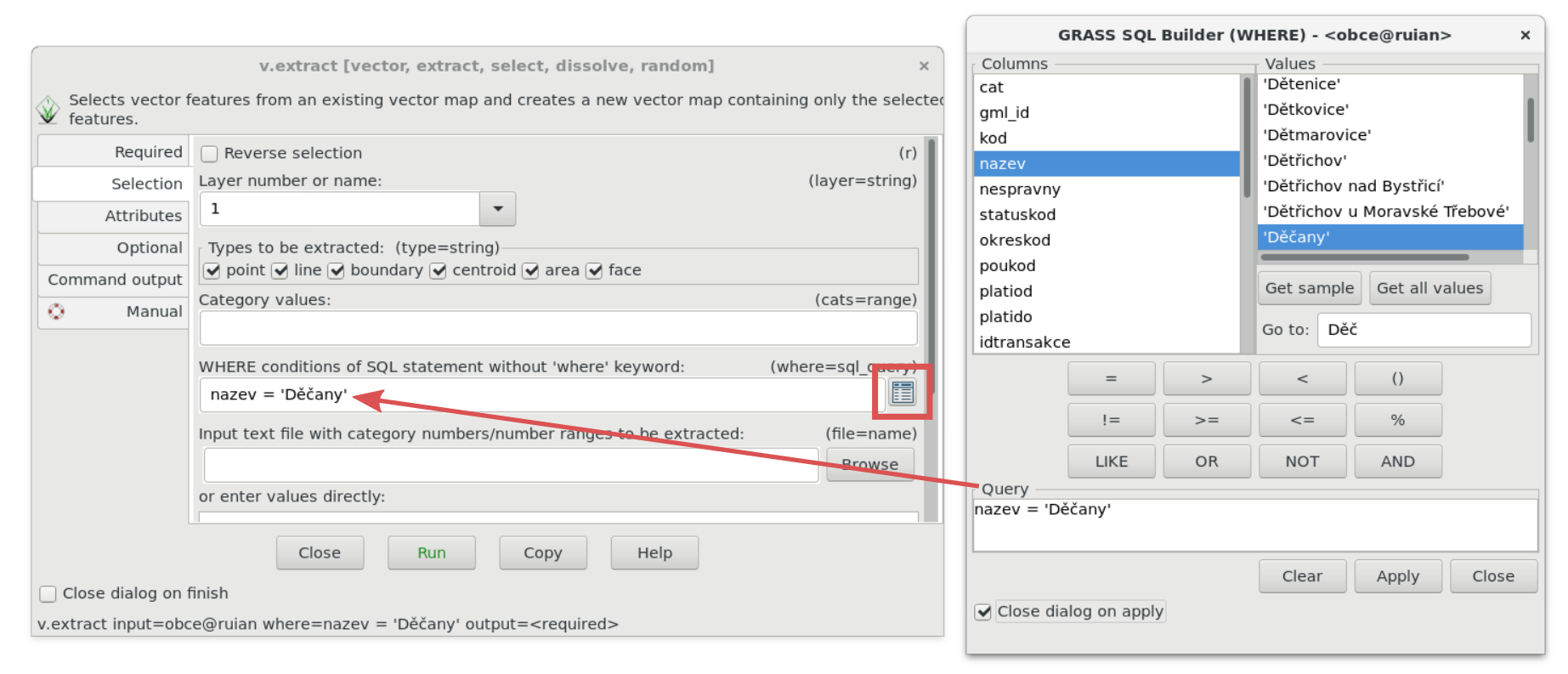
- New SQL where query widget

- G74:wxGUI: fix problem with Python addons not showing up on Windows, see #3177
- G74:wxGUI: fix d.vect dialog when loading layer without db connection
- G74:wxGUI: correctly delete layertree, see #3505
- G74:wxGUI: fix font dialog on mac, #3542
- wxGUI/dbmgr: improve get values speed
- G74:g.gui.tplot: resolved problem with stdvs when no categories are set, see #3294
- wxGUI/preferences: add new option for random colors (vector)
- wxGUI/datacatalog: zoom to first added map (sync with lmgr behaviour)
- wxGUI/datacatalog: display layer on double click
Scripting
- pygrass: add Module support to underscore in parameter's name
- PyGRASS: Category.init expects map name to be provided (r72227 backport)
Projection support
- Read EPSG codes with PROJ v.5 fail fixed (#3514)
Library changes
- libgis: more informative messages when (de)compression fails
- init: more messages for invalid location or mapset
- libgis: use G_vasprintf() to avoid buffer overflow
User Manuals - Documentation
- doc: show modules without img in graphical index
- G74:i.atcorr manual: added example to process Sentinel bands (contributed by Zofie Cimburova); general manual clean-up
- G74:i.vi: corrected MSAVI2 equation according
- G74:r.colors manual: decipher 'nv' color
- G74:r.in.wms manual: some WMS examples updated
- G74:r.series.accumulate manual: update manual explaining accumulation
- G74:r.stats.zonal manual: added link to r.stats.quantile
- G74:t.rast.algebra manual: add NDVI example; use subsections for examples
- G74:t.rast.algebra manual: formatting fixed + See also section added
- G74:t.register manual: added example to register vector layers (contributed by Ondrej Pesek) and other minor changes/typos
- G74:v.select: make it clear that 'overlap' is 'intersects' in GEOS, not 'overlaps'
Portability
- bump supported Python version to 2.7
- store grass.appdata.xml under share/metainfo/org.osgeo.grass.appdata.xml
- G74:r.random.surface: rename variable Surface to RSurface to avoid variable clash with GDAL on EPEL7
Message Translations
- i18N: msg update in PO files from source code
- i18N: added Hungarian from Transifex (https://www.transifex.com/grass-gis/grass72/dashboard/)
- i18N: sync from Transifex (https://www.transifex.com/grass-gis/grass72/dashboard/) except for Latvian; Latvian sync'ed from trunk files
New Addons since GRASS 7.4.0
Closed tickets
Closed bugs since the last release
- #2790
- Output of t.rast.list with method=comma and columns=name does not differ from output with columns=id
- #3059
- r.external.out does not write CRS information
- #3151
- raster digitizer crashes GUI in trunk
- #3223
- r.info displays wrong timestamp after t.rast.series with a where clause
- #3332
- v.proj - Error in pj_do_transform
- #3344
- r.stream.slope Segmentation fault: 11 error
- #3450
- 7.4.0 new modules missing in GUI menus
- #3469
- i.atcorr: Sentinel-2 support broken on some systems
- #3484
- Patch to fix spelling errors
- #3488
- v.in.ogr mangeling of column names when imporing OSM geojson extracts
- #3492
- r.texture overwrites without --o flag and without any warning when map exists
- #3493
- Compilation error with python 2.6
- #3496
- v.in.pdal: does not compile with PDAL 1.6.0
- #3505
- Opening a workspace file
- #3514
- Read EPSG codes with PROJ v.5 fails
- #3536
- python library db_table_in_vector function
- #3542
- cannot set default font in preferences
- #3546
- t.rast.what: issues in one_point_per_col_output()
- #3557
- Patch to fix spelling errors
- #3567
- v.select: doubtful result with the default overlap operator selecting areas with lines
Closed wishes since the last release
- #789
- g.region option to expand the computational region of about "some" pixels?
- #1878
- Metric distance option for v.distance in latlon regions
- #2122
- v.to.db: new variables to add
- #2183
- v.centerpoint: category values in ascii output should include original cat values
- #2234
- wxGUI d.mon and g.gui monitor rendering is slow
- #2368
- Python version of r.grow does not support shrinking
- #2417
- r.profile should report distance in location units
- #2896
- Allow installation of specific versions of GRASS addons
- #3416
- t.list: add mapset option as in g.list
- #3482
- i.atcorr: Add Sentinel-2B
- #3511
- [patch] v.buffer: allow squared buffers around points
Attachments (4)
-
grass-modeler-finished-new.png
(134.3 KB
) - added by 6 years ago.
wxGUI Graphical Modeler: print computational time elapsed
-
grass-modeler-intermediate-data-new.png
(257.7 KB
) - added by 6 years ago.
wxGUI Graphical Modeler: delete intermediate data when computation finished
-
grass-modeler-display-data-new.png
(343.5 KB
) - added by 6 years ago.
wxGUI Graphical Modeler: mark data to be displayed
-
wxgui-sqlwhere-select.png
(289.3 KB
) - added by 6 years ago.
SQL Where Select Widget
Download all attachments as: .zip
Note:
See TracWiki
for help on using the wiki.