
Opened 12 years ago
Last modified 9 years ago
#1689 new defect
weird import with r.in.gdal — at Version 2
| Reported by: | madi | Owned by: | |
|---|---|---|---|
| Priority: | normal | Milestone: | 6.4.6 |
| Component: | Raster | Version: | svn-releasebranch64 |
| Keywords: | r.in.gdal | Cc: | madi |
| CPU: | x86-64 | Platform: | Linux |
Description (last modified by )
Hi all,
I pointed this out already in ML, but in the same thread there were many topics so that i better separate this one in a dedicated ticket. I have generated a vrt file by this procedure http://grass.osgeo.org/wiki/Large_raster_data_processing and imported it into grass with the following commands:
r.in.gdal input="/forest/ASTER-GDEM/Dem_lzw/mosaic.vrt" output="mosaic"
and
r.external -r input="/forest/ASTER-GDEM/Dem_lzw/mosaic.vrt" output="mosaic2"
Then, comparing mosaic and mosaic2, i get:
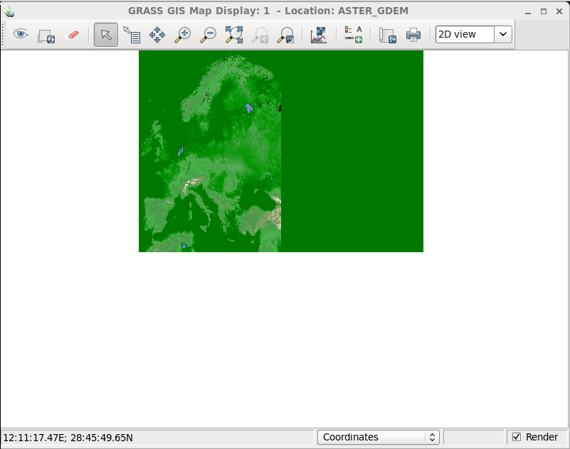
GRASS 6.4.3svn (ASTER_GDEM):~ > r.info map=mosaic
 +----------------------------------------------------------------------------+
 | Layer:    mosaic                         Date: Tue Jul 17 17:57:31 2012    |
 | Mapset:   PERMANENT                      Login of Creator: leomarg         |
 | Location: ASTER_GDEM                                                       |
 | DataBase: /forest/GRASS/grassdata                                          |
 | Title:     ( mosaic )                                                      |
 | Timestamp: none                                                            |
 |----------------------------------------------------------------------------|
 |                                                                            |
 |   Type of Map:  raster               Number of Categories: 6518            |
 |   Data Type:    CELL                                                       |
 |   Rows:         140401                                                     |
 |   Columns:      198001                                                     |
 |   Total Cells:  27799538401                                                |
 |        Projection: Latitude-Longitude                                      |
 |            N: 72:00:00.5N    S: 32:59:59.5N   Res: 0:00:01                 |
 |            E: 44:00:00.5E    W: 11:00:00.5W   Res: 0:00:01                 |
 |   Range of data:    min = -9999  max = 6518                                |
 |                                                                            |
 |   Data Description:                                                        |
 |    generated by r.in.gdal                                                  |
 |                                                                            |
 |   Comments:                                                                |
 |    r.in.gdal input="/forest/ASTER-GDEM/Dem_lzw/mosaic.vrt" output="mosa\   |
 |    ic"                                                                     |
 |                                                                            |
 +----------------------------------------------------------------------------+
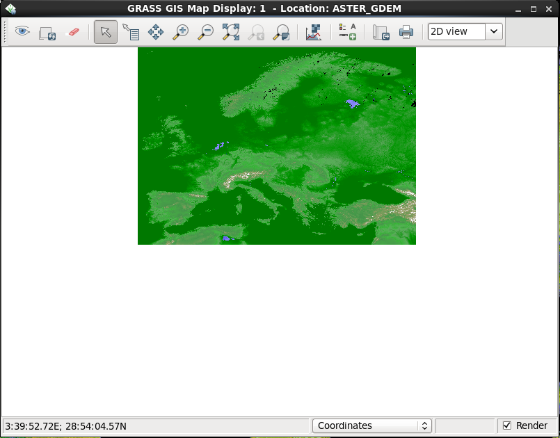
GRASS 6.4.3svn (ASTER_GDEM):~ > r.info map=mosaic2
 +----------------------------------------------------------------------------+
 | Layer:    mosaic2                        Date: Wed Jul 18 10:54:37 2012    |
 | Mapset:   PERMANENT                      Login of Creator: leomarg         |
 | Location: ASTER_GDEM                                                       |
 | DataBase: /forest/GRASS/grassdata                                          |
 | Title:     ( mosaic2 )                                                     |
 | Timestamp: none                                                            |
 |----------------------------------------------------------------------------|
 |                                                                            |
 |   Type of Map:  raster               Number of Categories: 0               |
 |   Data Type:    CELL                                                       |
 |   Rows:         140401                                                     |
 |   Columns:      198001                                                     |
 |   Total Cells:  27799538401                                                |
 |        Projection: Latitude-Longitude                                      |
 |            N: 72:00:00.5N    S: 32:59:59.5N   Res: 0:00:01                 |
 |            E: 44:00:00.5E    W: 11:00:00.5W   Res: 0:00:01                 |
 |   Range of data:    min = -9999  max = 6518                                |
 |                                                                            |
 |   Data Description:                                                        |
 |    generated by r.external                                                 |
 |                                                                            |
 |   Comments:                                                                |
 |    r.external -r input="/forest/ASTER-GDEM/Dem_lzw/mosaic.vrt" output="\   |
 |    mosaic2"                                                                |
 |                                                                            |
 +----------------------------------------------------------------------------+
The problem is that with r.in.gdal, the map is shrinked, while the map produced by r.external is correct. See the attached pictures.
Change History (4)
by , 12 years ago
| Attachment: | Screenshot-1.png added |
|---|
comment:1 by , 12 years ago
| Cc: | added |
|---|
comment:2 by , 12 years ago
| Description: | modified (diff) |
|---|
trac tips of the day: use three curly brackets to quote ascii art, and no need to cc yourself: anyone who created, comments on, or otherwise touches the bug is added to the cc list automatically.
Hamish
map imported with r.external