
Opened 5 years ago
Closed 5 years ago
#974 closed defect (invalid)
Union of Polylines results in additional segments
| Reported by: | jerryfaust | Owned by: | |
|---|---|---|---|
| Priority: | minor | Milestone: | |
| Component: | Default | Version: | 3.4.2 |
| Severity: | Unassigned | Keywords: | UNION UNARYUNION |
| Cc: |
Description
Hello.
Hopefully I'm overlooking something simple. I am selecting a group of roads. I want to Union and Buffer them in order to search within the resulting polygon.
However, when I get back the union, there are additional line segments that did not exist in the original set.
I've tried individually Union'ing them, I've tried UnaryUnion of a multi-part polyline (MultiLineString). I've also clipper calls. And I always get a similar result.
I've tried reording the lines as I union them so that each union operation always involves line segments that touch eachother.
I'm hoping that there is something that I'm simply overlooking, or not understanding, or not using properly.
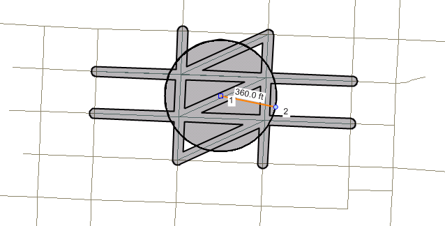
I'm attaching a snapshot of the circle used to 'select' the streets. I'm expecting a result something like a '#' sign, or tic-tac-toe. But I get additional diagonal lines in the result set.
Thank you for any feedback.
Regards. Jerry.
Attachments (2)
Change History (6)
by , 5 years ago
| Attachment: | Circular Container.PNG added |
|---|
by , 5 years ago
| Attachment: | Unioned Streets.PNG added |
|---|
comment:1 by , 5 years ago
comment:2 by , 5 years ago
this seems like a straightforward case for unioning lines, so it's very unlikely the problem is in GEOS. It's more likely to be caused by how GEOS is called. This has the appearance of a situation where the client code is providing the lines as a single list of coordinates, rather than a set of individual linestrings.
If possible please post a code snippet or even better a self-contained unit test showing the behaviour.
comment:3 by , 5 years ago
Thank you for the feedback.
I walked through the process again and found MY error. During one of the steps in my process, while reprojecting the points of the multi-part line, I lost the 'Parts', so it became an oddly connected single linestring.
Thanks again.
comment:4 by , 5 years ago
| Resolution: | → invalid |
|---|---|
| Status: | new → closed |
Thanks for the update. Have a good day.
Hi,
Can you share a snippet of code how you do it? (Coming from PostGIS land this looks like ST_MakeLine GEOS analogue used instead of ST_Union)
I haven't seen this behavior accessing GEOS via PostGIS.