| Version 4 (modified by , 16 years ago) ( diff ) |
|---|
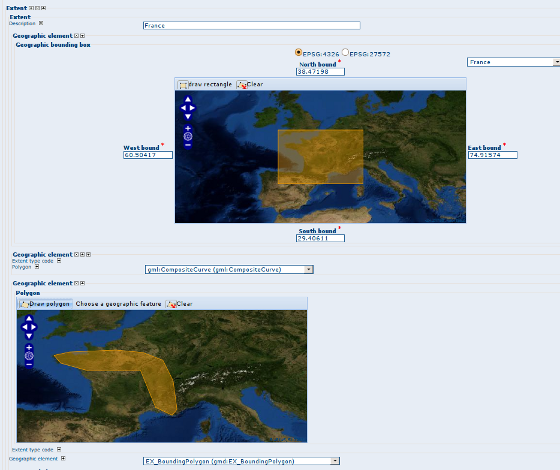
ISO19115 extent map editor and map viewer 
| Date | 2009/08/03 |
| Contact(s) | Francois, Patrick valsecchi, Eric Lemoine |
| Last edited | Timestamp |
| Status | draft |
| Assigned to release | 2.5.0 |
| Resources | Complete |
Overview 
Add a GeoExt map panel in order to draw and display on a map the bounding box or bounding polygon of an ISO 19115 metadata record. ...
Proposal Type 
- Type: GUI Change
- App: GeoNetwork
- Module: Editor
Links 
- Documents:
- Email discussions:
- Other wiki discussions:
Voting History 
- Vote proposed by X on Y, result was +/-n (m non-voting members).
Motivations 
The current configuration is based on:
- 4 input fields to define bounding box coordinates with a list of regions to quickly set up those 4 values.
- Bounding polygon could be define using GML object definition within the editor. But then user need to type coordinate of gmd:polygon elements manually.
The propsed change is to display a map in edit/view mode in order to be able to draw/display the metadata extent.

Proposal 
Description 
The map is in default WGS84 projection. In view mode:
- the map navigation is disabled
- the map zoom to the feature
- one map is displayed for each extent bounding polygon or bounding box.
In editing mode:
- a clear button allows to clear the feature on the map.
- navigation and mouse coordinate controls are available
- Bounding box
- a draw rectangle tool is activated for bounding box.
- the list of region is available to quickly define a bounding box and the description if available.
- if more than one projection is defined in the configuration file, editor could display coordinates in another projection (does not change map projection, only form field content).
- Bounding polygon
- a draw polygon tool is activated for bounding polygon
The config-gui.xml allows to define global parameters:
- map size
- list of projection (used to display bounding box coordinate in different projection.
Dependencies 
New librairies are needed:
- OpenLayers
- ExtJS
- GeoExt
These libraries will be needed for Intermap to OpenLayers migration also. ExtJS could also be used instead of the modalBox lib.
...
Known improvements 
- Change map projection.
- Select feature from WFS (on going)
Backwards Compatibility Issues 
Risks 
Participants 
- Francois
- Patrick
- Eric
Attachments (2)
- editor-geo-editing.png (167.9 KB ) - added by 16 years ago.
-
geoeditor.swf
(4.3 MB
) - added by 16 years ago.
Geographic extent editor and viewer screencast
Note:
See TracWiki
for help on using the wiki.