Opened 8 years ago
Last modified 8 years ago
#6293 closed defect
Multiple Pleiades/Airbus Tiles Don't Georegister Properly With gdalwarp — at Version 4
| Reported by: | edjansing | Owned by: | warmerdam |
|---|---|---|---|
| Priority: | high | Milestone: | 2.0.3 |
| Component: | default | Version: | unspecified |
| Severity: | major | Keywords: | gdalwarp, tiles, tfw, geotiff, georegistration |
| Cc: | bishop |
Description (last modified by )
Attempting to use gdalwarp to georegister several MSI tiles from Airbus' Pleiades sensor. A single area is provided in several tiles. In this example, here is the MSI directory listing with two tiles:
DIM_PHR1A_MS_201509141606268_SEN_1627093101-002.XML
ICON_PHR1A_MS_201509141606268_SEN_1627093101-002.JPG
IMG_PHR1A_MS_201509141606268_SEN_1627093101-002_R1C1.TFW
IMG_PHR1A_MS_201509141606268_SEN_1627093101-002_R1C1.TIF
IMG_PHR1A_MS_201509141606268_SEN_1627093101-002_R2C1.TFW
IMG_PHR1A_MS_201509141606268_SEN_1627093101-002_R2C1.TIF
INDEX.HTM
LIBRARY
LINEAGE
MASKS
PREVIEW_PHR1A_MS_201509141606268_SEN_1627093101-002.JPG
PREVIEW_PHR1A_MS_201509141606268_SEN_1627093101-002.KMZ
RPC_PHR1A_MS_201509141606268_SEN_1627093101-002.XML
The TFW files are unique between the two tiles. When I import the tiles into qgis, without any modification, it stitches them together properly, but they are not in the proper CRS (they are essentially referenced to pixel space, not to any CRS coordinate system).
When I use gdalwarp to put them in EPSG:4326, the first image is perfectly registered (the image with R1C1 as a suffix). The command used:
gdalwarp -rpc IMG_PHR1A_MS_201509141606268_SEN_1627093101-002_R1C1.TIF IMG_PHR1A_MS_201509141606268_SEN_1627093101-002_R1C1_projected.TIF
When I then gdalwarp the second image:
gdalwarp -rpc IMG_PHR1A_MS_201509141606268_SEN_1627093101-002_R2C1.TIF IMG_PHR1A_MS_201509141606268_SEN_1627093101-002_R2C1_projected.TIF
The second image does not get stitched at the bottom of the first image, but is placed at the top of the image, as if the tile starts at the same lat/lon coordinate (or at the same pixel location, whichever).
Is this normal behavior? Is there another procedure I should use? Can provide image data if helpful.
gdalwarp reports 2.0.0 as version gdalinfo on two original images:
$ gdalinfo IMG_PHR1A_MS_201509141606268_SEN_1627093101-002_R1C1.TIF
Driver: GTiff/GeoTIFF
Files: IMG_PHR1A_MS_201509141606268_SEN_1627093101-002_R1C1.TIF
       IMG_PHR1A_MS_201509141606268_SEN_1627093101-002_R1C1.TIF.aux.xml
       ./DIM_PHR1A_MS_201509141606268_SEN_1627093101-002.XML
       ./RPC_PHR1A_MS_201509141606268_SEN_1627093101-002.XML
       IMG_PHR1A_MS_201509141606268_SEN_1627093101-002_R1C1.TFW
Size is 9458, 15000
Coordinate System is `'
Origin = (-1.000000000000000,3.000000000000000)
Pixel Size = (4.000000000000000,-4.000000000000000)
Metadata:
  METADATATYPE=DIMAP
  TIFFTAG_DATETIME=2015:12:23 18:32:39
  TIFFTAG_IMAGEDESCRIPTION=B2 B1 B0 B3
  TIFFTAG_XRESOLUTION=1
  TIFFTAG_YRESOLUTION=1
Image Structure Metadata:
  INTERLEAVE=PIXEL
RPC Metadata:
  HEIGHT_OFF=45
  HEIGHT_SCALE=95
  LAT_OFF=38.87154971192919
  LAT_SCALE=0.1416732123880315
  LINE_DEN_COEFF= 1 0.00026341144632701 -9.80822136398733e-05 -2.35953356209866e-06 -1.62170380697022e-05 -1.22640028446246e-08 1.55023313626127e-07 -1.5537111237091e-05 4.58036130936434e-05 -2.31198284873618e-05 3.2864533726195e-09 -3.06927464009735e-08 2.08793797077866e-06 -1.21475710839433e-08 1.54788420545811e-07 -4.44599257156653e-07 1.70368489248657e-09 1.33031932377729e-10 -1.54424096736091e-08 1.05222239987211e-10
  LINE_NUM_COEFF= -0.000119096471843013 0.00273796193211152 -1.00367656228961 -0.000859086493278233 0.000261713135774831 2.33979663689761e-07 -2.25402196362394e-06 -0.000340119441043266 2.19730836249524e-05 1.66642358408085e-08 -4.29909520634416e-08 4.95298240422465e-08 -2.62364432140933e-05 -6.28870839700389e-08 1.52651889380179e-05 8.08563520366722e-05 2.3195367391933e-05 1.1804689412366e-08 1.00010692110933e-07 1.98020806117544e-08
  LINE_OFF=7772.5
  LINE_SCALE=7771.5
  LONG_OFF=-77.13546672147527
  LONG_SCALE=0.1165198796426168
  SAMP_DEN_COEFF= 1 0.000472894792539169 0.000881419369988542 -7.53324742935084e-05 -3.46629852664066e-05 -4.87301506925132e-08 1.32614018054834e-08 -2.1872832721835e-07 1.49479836237352e-05 -6.59860144983547e-06 -1.48728353597154e-08 -3.52095449470832e-08 -2.14688694596795e-07 -3.3168465870712e-09 4.03572496745229e-08 3.97707771445365e-07 -1.15020506050241e-08 2.66109369887284e-09 1.05965377023676e-08 9.65442134520645e-10
  SAMP_NUM_COEFF= -0.000434608495681351 1.00210264963283 -0.000281300697070519 0.000316194516045025 -0.000879304997048266 7.52970914458278e-05 -5.20633271426872e-05 -3.73769088263009e-05 0.00138775409674169 -2.73849487440847e-08 5.19133691835542e-08 -1.24502711479507e-05 -2.1363347686686e-05 -6.59563969341986e-06 5.20138704377129e-05 -3.41383248102939e-05 -2.02958513833057e-09 -3.71155366535213e-08 -2.25289299184377e-07 -2.06504369348464e-09
  SAMP_OFF=5000.5
  SAMP_SCALE=4999.5
Corner Coordinates:
Upper Left  (  -1.0000000,   3.0000000)
Lower Left  (      -1.000,  -59997.000)
Upper Right (   37831.000,       3.000)
Lower Right (   37831.000,  -59997.000)
Center      (   18915.000,  -29997.000)
Band 1 Block=9458x1 Type=UInt16, ColorInterp=Red
  Min=0.000 Max=3924.000
  Minimum=0.000, Maximum=3924.000, Mean=241.479, StdDev=247.675
  Metadata:
    STATISTICS_MAXIMUM=3924
    STATISTICS_MEAN=241.47873181735
    STATISTICS_MINIMUM=0
    STATISTICS_STDDEV=247.67541356986
Band 2 Block=9458x1 Type=UInt16, ColorInterp=Green
  Min=0.000 Max=3956.000
  Minimum=0.000, Maximum=3956.000, Mean=300.351, StdDev=253.536
  Metadata:
    STATISTICS_MAXIMUM=3956
    STATISTICS_MEAN=300.35078661846
    STATISTICS_MINIMUM=0
    STATISTICS_STDDEV=253.53558755775
Band 3 Block=9458x1 Type=UInt16, ColorInterp=Blue
  Min=0.000 Max=4095.000
  Minimum=0.000, Maximum=4095.000, Mean=348.032, StdDev=266.569
  Metadata:
    STATISTICS_MAXIMUM=4095
    STATISTICS_MEAN=348.03234066915
    STATISTICS_MINIMUM=0
    STATISTICS_STDDEV=266.56884586952
Band 4 Block=9458x1 Type=UInt16, ColorInterp=Undefined
$ gdalinfo IMG_PHR1A_MS_201509141606268_SEN_1627093101-002_R2C1.TIF
Driver: GTiff/GeoTIFF
Files: IMG_PHR1A_MS_201509141606268_SEN_1627093101-002_R2C1.TIF
       IMG_PHR1A_MS_201509141606268_SEN_1627093101-002_R2C1.TIF.aux.xml
       ./DIM_PHR1A_MS_201509141606268_SEN_1627093101-002.XML
       ./RPC_PHR1A_MS_201509141606268_SEN_1627093101-002.XML
       IMG_PHR1A_MS_201509141606268_SEN_1627093101-002_R2C1.TFW
Size is 9458, 544
Coordinate System is `'
Origin = (-1.000000000000000,-59997.000000000000000)
Pixel Size = (4.000000000000000,-4.000000000000000)
Metadata:
  METADATATYPE=DIMAP
  TIFFTAG_DATETIME=2015:12:23 18:32:39
  TIFFTAG_IMAGEDESCRIPTION=B2 B1 B0 B3
  TIFFTAG_XRESOLUTION=1
  TIFFTAG_YRESOLUTION=1
Image Structure Metadata:
  INTERLEAVE=PIXEL
RPC Metadata:
  HEIGHT_OFF=45
  HEIGHT_SCALE=95
  LAT_OFF=38.87154971192919
  LAT_SCALE=0.1416732123880315
  LINE_DEN_COEFF= 1 0.00026341144632701 -9.80822136398733e-05 -2.35953356209866e-06 -1.62170380697022e-05 -1.22640028446246e-08 1.55023313626127e-07 -1.5537111237091e-05 4.58036130936434e-05 -2.31198284873618e-05 3.2864533726195e-09 -3.06927464009735e-08 2.08793797077866e-06 -1.21475710839433e-08 1.54788420545811e-07 -4.44599257156653e-07 1.70368489248657e-09 1.33031932377729e-10 -1.54424096736091e-08 1.05222239987211e-10
  LINE_NUM_COEFF= -0.000119096471843013 0.00273796193211152 -1.00367656228961 -0.000859086493278233 0.000261713135774831 2.33979663689761e-07 -2.25402196362394e-06 -0.000340119441043266 2.19730836249524e-05 1.66642358408085e-08 -4.29909520634416e-08 4.95298240422465e-08 -2.62364432140933e-05 -6.28870839700389e-08 1.52651889380179e-05 8.08563520366722e-05 2.3195367391933e-05 1.1804689412366e-08 1.00010692110933e-07 1.98020806117544e-08
  LINE_OFF=7772.5
  LINE_SCALE=7771.5
  LONG_OFF=-77.13546672147527
  LONG_SCALE=0.1165198796426168
  SAMP_DEN_COEFF= 1 0.000472894792539169 0.000881419369988542 -7.53324742935084e-05 -3.46629852664066e-05 -4.87301506925132e-08 1.32614018054834e-08 -2.1872832721835e-07 1.49479836237352e-05 -6.59860144983547e-06 -1.48728353597154e-08 -3.52095449470832e-08 -2.14688694596795e-07 -3.3168465870712e-09 4.03572496745229e-08 3.97707771445365e-07 -1.15020506050241e-08 2.66109369887284e-09 1.05965377023676e-08 9.65442134520645e-10
  SAMP_NUM_COEFF= -0.000434608495681351 1.00210264963283 -0.000281300697070519 0.000316194516045025 -0.000879304997048266 7.52970914458278e-05 -5.20633271426872e-05 -3.73769088263009e-05 0.00138775409674169 -2.73849487440847e-08 5.19133691835542e-08 -1.24502711479507e-05 -2.1363347686686e-05 -6.59563969341986e-06 5.20138704377129e-05 -3.41383248102939e-05 -2.02958513833057e-09 -3.71155366535213e-08 -2.25289299184377e-07 -2.06504369348464e-09
  SAMP_OFF=5000.5
  SAMP_SCALE=4999.5
Corner Coordinates:
Upper Left  (      -1.000,  -59997.000)
Lower Left  (      -1.000,  -62173.000)
Upper Right (   37831.000,  -59997.000)
Lower Right (   37831.000,  -62173.000)
Center      (   18915.000,  -61085.000)
Band 1 Block=9458x1 Type=UInt16, ColorInterp=Red
  Min=0.000 Max=3131.000
  Minimum=0.000, Maximum=3131.000, Mean=303.059, StdDev=222.224
  Metadata:
    STATISTICS_MAXIMUM=3131
    STATISTICS_MEAN=303.05929724396
    STATISTICS_MINIMUM=0
    STATISTICS_STDDEV=222.22368384095
Band 2 Block=9458x1 Type=UInt16, ColorInterp=Green
  Min=0.000 Max=3071.000
  Minimum=0.000, Maximum=3071.000, Mean=389.381, StdDev=199.449
  Metadata:
    STATISTICS_MAXIMUM=3071
    STATISTICS_MEAN=389.38147159371
    STATISTICS_MINIMUM=0
    STATISTICS_STDDEV=199.44912482837
Band 3 Block=9458x1 Type=UInt16, ColorInterp=Blue
  Min=0.000 Max=3020.000
  Minimum=0.000, Maximum=3020.000, Mean=453.803, StdDev=187.787
  Metadata:
    STATISTICS_MAXIMUM=3020
    STATISTICS_MEAN=453.8029269754
    STATISTICS_MINIMUM=0
    STATISTICS_STDDEV=187.78652664007
Band 4 Block=9458x1 Type=UInt16, ColorInterp=Undefined
TFW files:
$ cat IMG_PHR1A_MS_201509141606268_SEN_1627093101-002_R1C1.TFW
4.00000000000000
0
0
-4.00000000000000
1.00000000000000
1.00000000000000
$ cat IMG_PHR1A_MS_201509141606268_SEN_1627093101-002_R2C1.TFW
4.00000000000000
0
0
-4.00000000000000
1.00000000000000
-59999.00000000000000
Change History (6)
by , 8 years ago
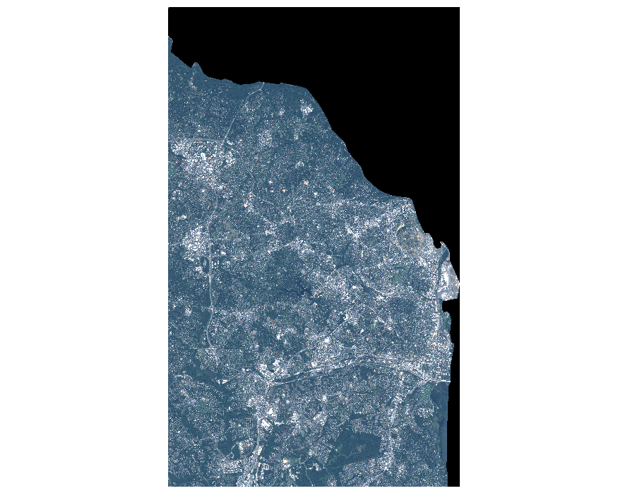
| Attachment: | 2015-01-06_stitchedTogetherProperlyButNotInRightCRS.png added |
|---|
by , 8 years ago
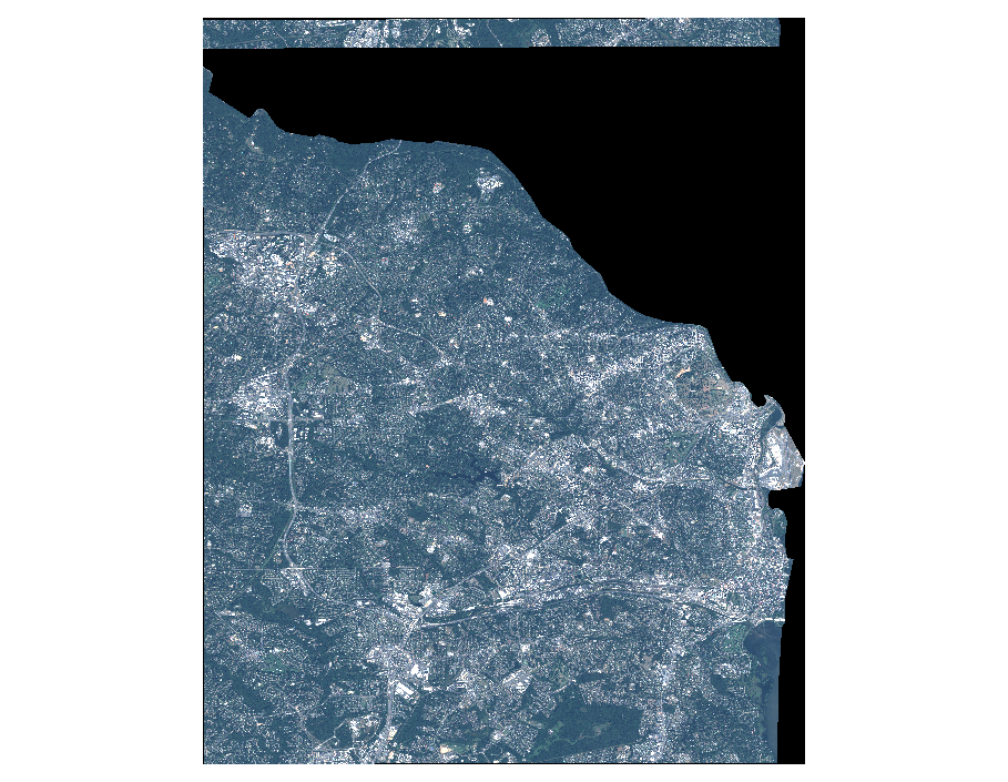
| Attachment: | 2015-01-06_stitchedTogetherInCorrectlyButInRightCRS.png added |
|---|
Improperly stitched, but in EPSG:4326 CRS
comment:1 by , 8 years ago
Two things :
- You should pass the 2 images in the same gdalwarp command "gdalwarp -rpc in1.tif in2.tif out.tif". If you do in several times, it will not increase the raster dimension & georeferenced extent of the first output.
- You could try removing the .TFW files as I'm wondering if they don't confuse gdalwarp
comment:2 by , 8 years ago
Tried the following:
- Passing both images into the same gdalwarp command. No improvement.
- Passing both images into the same gdalwarp command, without the TFW files. No improvement.
- Processing each image separately, without the TFW files. No improvement.
comment:3 by , 8 years ago
Used:
gdalwarp -rpc -dstnodata 0 -r cubic first.tif second.tif output.tif
comment:4 by , 8 years ago
| Description: | modified (diff) |
|---|
Properly stitched, not in CRS