#6070 closed defect (fixed)
EDIGEO driver : geometries distorded (simplified ?) in Linux and NOT in Windows platform
| Reported by: | kimaidou | Owned by: | warmerdam |
|---|---|---|---|
| Priority: | high | Milestone: | 1.11.3 |
| Component: | default | Version: | unspecified |
| Severity: | critical | Keywords: | edigeo |
| Cc: |
Description (last modified by )
Problem :
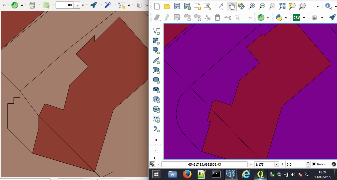
- polygon geometries seems distorded under Linux (look like over-simplified), and not under Windows. This lead to wrong data when using ogr2ogr to imprt files in PostGIS or export to Shapefile.
CF attached image: ubuntu box on the left side / Windows box on the right side, same THF
Steps to reproduce:
- Open some EDIGEO THX file with QGIS in a Linux box (tested with Ubuntu and OpenSuze ) build with GDAL/OGR 1.11.2
- Open the same file with QGIS in Windows , build also with GDAL/OGR 1.11.2

Attachments (4)
Change History (11)
by , 9 years ago
| Attachment: | bug_ogr_edigeo_linux.png added |
|---|
comment:1 by , 9 years ago
| Description: | modified (diff) |
|---|
comment:2 by , 9 years ago
comment:3 by , 9 years ago
| Summary: | EDIGEO driver : geometries distorded (simplified ?) in Linux and in Windows platform → EDIGEO driver : geometries distorded (simplified ?) in Linux and NOT in Windows platform |
|---|
by , 9 years ago
| Attachment: | ogrinfo_linux.txt added |
|---|
by , 9 years ago
| Attachment: | ogrinfo_windows.txt added |
|---|
by , 9 years ago
| Attachment: | commune-edigeo-020.tar.bz2 added |
|---|
comment:4 by , 9 years ago
I meant full dumps with "ogrinfo -al XXXXXXX". Anyway I've just tried on my own custom builds (with GDAL trunk) and I don't get any significant differences (just in the SRS definition but likely due to different proj.4 versions, and some neglectable floating-point differences in an attribute, but geometries are strictly identical)
comment:5 by , 9 years ago
Thanks for your help. It must simply be a decimal separator problem then. It really looks like nodes are "moved" to a 1mX1m grid. I will try to run qgis command line with LC_NUMERIC="C" and report back
comment:6 by , 9 years ago
| Resolution: | → fixed |
|---|---|
| Status: | new → closed |
Ah this is very likely ! I indeed see atof() calls in the 1.11 version of the driver have been convererted to locale insensite CPLAtof() in 2.0 during the global pass done on such issues.
Backporting that in 1.11 branch (just for EDIGEO driver) r29641 "EDIGEO: backport 2.0 conversion of atof() to CPLAtof() to avoid truncatof floating point numbers including coordinates on a non C locale (#6070)"
comment:7 by , 9 years ago
Just tried with export LC_NUMERIC="C" && qgis and geometries are now OK
Thanks a lot for this fix and backporting.
It feels like a SnapToGrid more than a simplification