Opened 9 years ago
Last modified 9 years ago
#6060 closed enhancement
AAIGrid: writing float types should ensure that a decimal is in the first pixel — at Version 1
| Reported by: | Mike Taves | Owned by: | warmerdam |
|---|---|---|---|
| Priority: | normal | Milestone: | 2.0.1 |
| Component: | default | Version: | svn-trunk |
| Severity: | normal | Keywords: | aaigrid |
| Cc: |
Description (last modified by )
TL; DR: for float ASC rasters, ensure the first pixel value has a ., e.g.
…
cellsize     1.000000000000
 0. 0 0 0 0 0 0 0 0 0 0 0 0 0 0 0 0 0 0 0 0 0 0 0 0 0 0 0 0 0 0 0 0 0 0
…
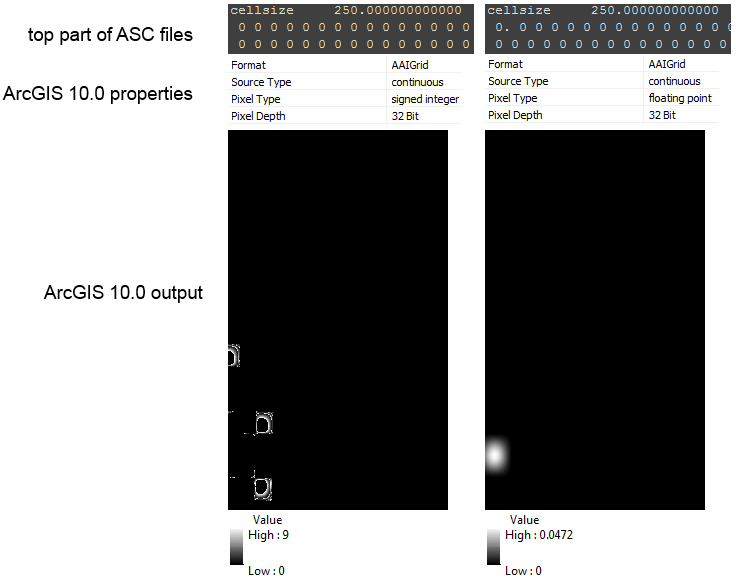
ESRI ASCII Grid files (ASC) do not explicitly store their datatypes, so when ASC rasters are opened by GDAL or other software, the data type is evaluated from some/all of the pixel data to see if there is a . character.
While GDAL is fairly robust at correctly interpreting if a raster is integer or float type, other software such as ArcGIS is not. For instance, a raster that is mostly zero is interpreted by ArcGIS as signed integer. But modify the first pixel of the ASC file from 0 to 0. corrects the interpretation to floating point. (This is not an issue with GDAL, which evaluates 100% of the data, not 100 kB as documented).

A suggestion for writing float rasters is to check if the formatted string of the first pixel of the first line has a . character. If not, and the value is finite (not NaN, Inf, etc.), append a . to that first value.
Change History (2)
by , 9 years ago
| Attachment: | Comparison_of_asc.png added |
|---|
comment:1 by , 9 years ago
| Description: | modified (diff) |
|---|
Comparison of Arc ASCII Grid files in ArcGIS 10.0