| Version 2 (modified by , 15 years ago) ( diff ) |
|---|
PostGIS WKT Raster Beta 0.1 Final Specifications
Quick Links
Objective 0.1.6c - Being able to load rasters in the database
gdal2wktraster.py - A prototype of the translation utility implemented in Python and with use of GDAL and its bindings to Python. Create an SQL commands output to create a table of raster. As input raster file, all GDAL formats are accepted. The script is available as gdal2wktraster.py script.
Open Questions:
- Should we change names of options to strictly follow those used by raster2pgsql and shp2pgsql?
Pierre: Yes! We should follow PostGIS tracks as much as possible in everything we do in this project.
- How can I import all the bands from a multiband TIFF?
USAGE:
gdal2wktraster.py -r rasterfile [-r rasterfile] -t [<schema>.]<table> [<options>]
-r <rasterfile> Specifies input raster file. Multiple -r options can be specified for a number of input files or wildcards can be used (? and *). At least one input raster file is REQUIRED.
-t <table> Name of destination table in with or without target schema specified. This parameter is REQUIRED.
OPTIONS:
-s <srid> Set the SRID field. Default is -1.
-b <nbband> Specify the number of band. The number of rasterfile must correspond to this number.
-f <field> Name of target column for raster data. Default column name is rast.
-I Create a GiST index on the raster column.
-o <file> Output file for generated SQL commands. If not specified, stdout is assumed.
-R Simply register the raster in the database. Absolute path to the raster and georeferencing informations are stored instead of the raster actual data.
-F Add a "filename" column containing the original name of the loaded raster file.
(-d|c) Mutually exclusive inserting options:
-d Drops the table, then recreates it and populates it with current raster file data.
-c Creates a new table and populates it, this is the default if you do not specify any options.
-v Switch on excessively verbose mode, useful for debugging.
-h Display this help screen.
Objective 0.1.6d - Being able to get all the properties of a raster (all the “Get” functions).
RT_SRID(raster|geometry) → integer
Return the SRID associated with the raster.
RT_Width(raster) → integer
Return the width of the raster.
RT_Height(raster) → integer
Return the height of the raster.
RT_PixelSizeX(raster) → float64
Return the georeference's X pixel size of the raster. See.
RT_PixelSizeY(raster) → float64
Return the georeference's Y pixel size of the raster. See.
RT_RotationX(raster) → float64
Return the georeference's X rotation.
RT_RotationY(raster) → float64
Return the georeference's Y rotation. See.
RT_UpperLeftX(raster) → float64
Return the georeference's X-coordinate of the center of the upper left pixel. See.
RT_UpperLeftY(raster) → float64
Return the georeference's Y-coordinate of the center of the upper left pixel. See.
RT_GeoReference(raster) → string
Return the georeference of the raster as a string representing the 6 doubles of an equivalent world file (including the carriage return). See.
RT_NumBands(raster) → integer
Return the number of band included in the raster.
RT_BandPixelType(raster, integer) → string
Return the pixel type of the specified 1-based Nth band of raster. Band index is 1-based. The function returns one of the following values:
- 1BB - 1-bit boolean
- 2BUI - 2-bit unsigned integer
- 4BUI - 4-bit unsigned integer
- 8BSI - 8-bit signed integer
- 8BUI - 8-bit unsigned integer
- 16BSI - 16-bit signed integer
- 16BUI - 16-bit unsigned integer
- 32BSI - 32-bit signed integer
- 32BUI - 32-bit unsigned integer
- 16BF - 16-bit float
- 32BF - 32-bit float
- 64BF - 64-bit float
RT_BandNoDataValue(raster, integer) → float32
Return the NoDataValue of the specified 1-based Nth band of raster. Band index is 1-based. The value is always returned as a float32 even if the pixel type is integer.
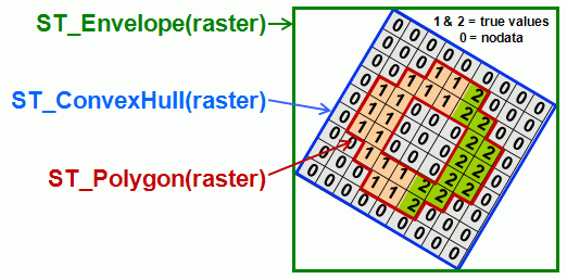
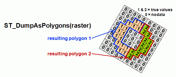
Attachments (2)
- WKTRasterEnvelopeConvexHullAndPolygon.gif (21.8 KB ) - added by 14 years ago.
- WKTRasterAsPolygon.gif (20.0 KB ) - added by 14 years ago.
Download all attachments as: .zip