
| Version 9 (modified by , 10 years ago) ( diff ) |
|---|
Orthorectification
 |
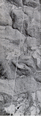 |
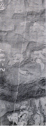
| Above are 2 images of the same geographic area. Note the road that passes through the mountains. In the left "raw" or unrectified image, the road appears to be crooked when in fact it is not. The image on the right has been rectified image and the road appears planimetrically correct. | |
Orthorectification is the process of removing the effects of image perspective (tilt) and relief (terrain) effects for the purpose of creating a planimetrically correct image. The resultant orthorectified image has a constant scale wherein features are represented in their 'true' positions. This allows for the accurate direct measurement of distances, angles, and areas (i.e. mensuration). Orthorectified images are commonly used as in visualization tools such as Google Earth, OSSIM Planet, ArcMap, WMS, etc.
The requisite inputs for orthorectification:
- An image with accurate sensor geometry
- A elevation model of the ground surface in DEM, DTED, or SRTM format
The resulting accuracy of the orthoimage is based on the accuracy of the triangulation, the resolution of the source image, and the accuracy of the elevation model.
Related Links
- Tilt Displacement
- Relief Displacement
- OSSIM Sensor Modeling
- How to set up elevation in OSSIM
- ossim-orthoigen:
- Command line application used to orthorectify images and create orthoimage mosaics.
Attachments (2)
- pre-ortho.jpg (74.8 KB ) - added by 14 years ago.
- post-ortho.jpg (71.1 KB ) - added by 14 years ago.
Download all attachments as: .zip
