
Opened 20 years ago
Closed 20 years ago
#829 closed defect (worksforme)
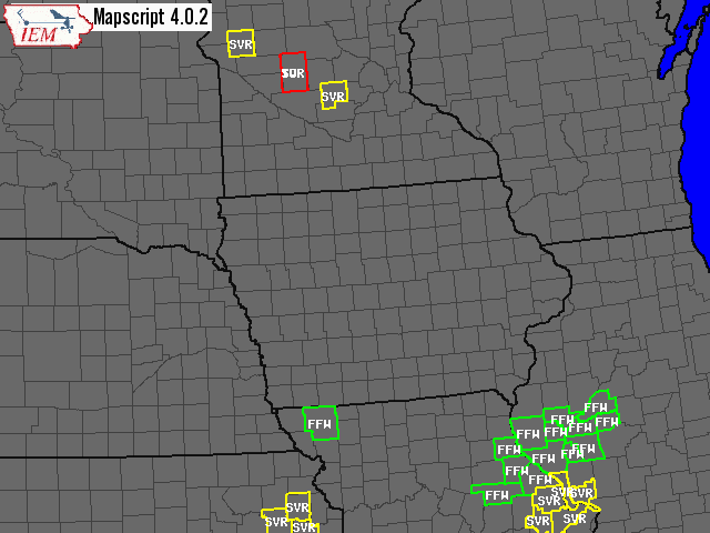
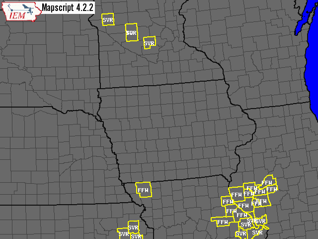
Classification broken in >= 4.2, works in 4.0.2
| Reported by: | Owned by: | ||
|---|---|---|---|
| Priority: | high | Milestone: | |
| Component: | MapServer CGI | Version: | 4.2 |
| Severity: | normal | Keywords: | |
| Cc: | sgillies@… |
Description
Hi,

I have a layer that would correctly classify in MS 4.0.2, but now fails in MS
4.2 or greater.  This is failing with a PostGIS layer and now a shapefile layer
as well.  I must be doing something very stupid.  Here is my layer:

LAYER
  NAME warnings0_c
  DATA warnings.shp
  STATUS ON
  TYPE POLYGON
  TEMPLATE q_template.html
  PROJECTION
   "init=epsg:4326"
  END
  CLASSITEM "TYPE"
  LABELITEM "TYPE"
  CLASS
    EXPRESSION 'TOR'
    COLOR -1 -1 -1
    OUTLINECOLOR 255 0 0
    SIZE 2
    SYMBOL 1
    LABEL
      TYPE BITMAP
      SIZE MEDIUM
      COLOR 250 250 250
      PARTIALS TRUE
      FORCE TRUE
    END
  END
  CLASS
    EXPRESSION 'SVR'
    COLOR -1 -1 -1
    OUTLINECOLOR 255 255 0
    SIZE 2
    SYMBOL 1
    LABEL
      TYPE BITMAP
      SIZE MEDIUM
      COLOR 250 250 250
      PARTIALS TRUE
      FORCE TRUE
    END
  END
  CLASS
    EXPRESSION 'FFW'
    COLOR -1 -1 -1
    OUTLINECOLOR 0 255 0
    SIZE 2
    SYMBOL 1
    LABEL
      TYPE BITMAP
      SIZE MEDIUM
      COLOR 250 250 250
      PARTIALS TRUE
      FORCE TRUE
    END
  END
END

Attached maps coming next!
thanks,
  daryl
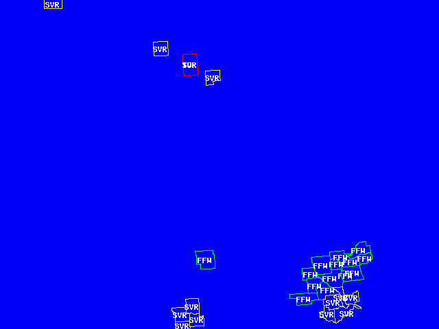
Attachments (4)
Change History (10)
by , 20 years ago
| Attachment: | warnings.zip added |
|---|
comment:1 by , 20 years ago
Daryl, I'm not aware of any intended changes in the way that polygon
classification works.  If you are really using the same mapfile and
same data sources, I don't think it is user error.

Did you try any other versions of MapServer?  Or only 4.0.2 and 4.2.2.
comment:2 by , 20 years ago
Howdy,

I tried 4.2.0 as well.  This worked back in 3.x as well. It just started to fail
once I tried using 4.2.x .   The shapefile I have attached doesn't look right,
the attributes are all messed up.  One of my postgis fields is a text field and
that may be causing trouble with pgsql2shp.  Regardless, the postgis layer
exhibits the same behaviour as well.  My postgis data line is:

DATA "geom from (select type as wtype, geom, oid from warnings WHERE
  gtype = 'C' and expire > '2004-08-25 17:25' and issue < '2004-08-25 17:25'
  ORDER by expire, type ASC) as foo"

for this query, I don't do anything with the text field, so Mapserver shouldn't
even be seeing it...

daryl
comment:3 by , 20 years ago
Daryl,

Here is the layer definition that I used to test.  I'm using your server,
and commented out the ip below.

LAYER
  CONNECTIONTYPE postgis
  NAME warnings0_c
  CONNECTION "user=akrherz dbname=postgis host=xxx.xxx.xxx.xxx"
  DATA "geom from (select type as wtype, geom, oid from warnings WHERE gtype =
'C' and expire > '2004-08-25 17:25' and issue < '2004-08-25 17:25' ORDER by
expire, type ASC) as foo"
  STATUS DEFAULT
  TYPE POLYGON
  DEBUG ON
  TEMPLATE q_template.html
  PROJECTION
   "init=epsg:4326"
  END
  CLASSITEM "wtype"
  LABELITEM "wtype"
  CLASS
    EXPRESSION 'TOR'
    COLOR -1 -1 -1
    OUTLINECOLOR 255 0 0
    SIZE 2
    SYMBOL 0
    LABEL
      TYPE BITMAP
      SIZE MEDIUM
      COLOR 250 250 250
      PARTIALS TRUE
      FORCE TRUE
    END
  END
  CLASS
    EXPRESSION 'SVR'
    COLOR -1 -1 -1
    OUTLINECOLOR 255 255 0
    SIZE 2
    SYMBOL 0
    LABEL
      TYPE BITMAP
      SIZE MEDIUM
      COLOR 250 250 250
      PARTIALS TRUE
      FORCE TRUE
    END
  END
  CLASS
    EXPRESSION 'FFW'
    COLOR -1 -1 -1
    OUTLINECOLOR 0 255 0
    SIZE 2
    SYMBOL 0
    LABEL
      TYPE BITMAP
      SIZE MEDIUM
      COLOR 250 250 250
      PARTIALS TRUE
      FORCE TRUE
    END
  END
END

Works for me.  See attached image.  I think it was all in your classitem.
Should be "wtype".

Can you confirm?
comment:4 by , 20 years ago
Well, Sean's revised layer section now works for me.  I just don't understand
why my old layer was interacting the way it was, but it works now, so thanks
much Sean.
comment:5 by , 20 years ago
| Owner: | changed from to |
|---|
comment:6 by , 20 years ago
| Resolution: | → worksforme |
|---|---|
| Status: | new → closed |
Note:
See TracTickets
for help on using tickets.
example shapefile used in this test