
Opened 20 years ago
Closed 17 years ago
#770 closed enhancement (fixed)
MapServer/GEOS integration
| Reported by: | sdlime | Owned by: | sdlime |
|---|---|---|---|
| Priority: | high | Milestone: | 4.6 release |
| Component: | MapServer C Library | Version: | unspecified |
| Severity: | minor | Keywords: | |
| Cc: | sgillies@… |
Description (last modified by )
A tracker for integrating MapServer and GEOS. To date I've got skeletal code in
place, and the build environment all configured. Nothing has been checked in
yet...

Steve
Attachments (1)
Change History (12)
comment:2 by , 20 years ago
| Status: | new → assigned |
|---|
Your loss I guess... ;-) It'll be awhile before I can get back to that code
seriously though...
comment:3 by , 19 years ago
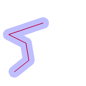
Made large strides with this today. I have most simple conversions working
although I do need to work on collections (multi-point/line/polygon) and
MapServer polygons to GEOS in general. MapServer is very (too?) flexible so
polygons will be tricky. However, I've tested with simple points and line
strings and it works nicely. At this point the only exposed method is for
buffering via MapScript. So you can do stuff like:

$point = new mapscript::pointObj();
$line = new mapscript::lineObj();
$shape = new mapscript::shapeObj($mapscript::MS_SHAPE_LINE);

$point->{x} = 50;
$point->{y} = 50;
$line->add($point);
$point->{x} = 100;
$point->{y} = 90;
$line->add($point);
$point->{x} = 90;
$point->{y} = 150;
$line->add($point);
$point->{x} = 30;
$point->{y} = 180;
$line->add($point);
$point->{x} = 150;
$point->{y} = 220;
$line->add($point);
$shape->add($line);

$map = new mapscript::mapObj('buffer.map') or die 'could not load map';

$buffered_shape = $shape->buffer(20) or die 'buffer failed';
$layer = $map->getLayerByName('buffer') or die 'could not get layer';
$layer->{status} = $mapscript::MS_ON;
$layer->addFeature($buffered_shape);

$layer = $map->getLayerByName('nobuffer') or die 'could not get layer';
$layer->{status} = $mapscript::MS_ON;
$layer->addFeature($shape);

$image = $map->draw();
$image->save('test.gif');

Pretty slick. Could query, save or whatever now with that new shape. Ton's of
possibilities...

Steve
comment:4 by , 19 years ago
Steve, we need to think about what it means to be adding GEOS-only methods
into mapscript.  Howard's windows builds are failing.

I've tried hard to keep mapserver macros (like USE_GEOS) out of the SWIG
interface files because of the extra complexity that adds to mapscript
compilation.  It's better to keep all that isolated in libmap.  I think that you
should be making stubs for the functions in mapgoes.cpp that raise errors when
GEOS support isn't available.  Like the various OWS and SLD functions do.
comment:5 by , 19 years ago
They do raise errors as with other modules, check for yourself. The
msGEOSBuffer and msGEOSConvexHull functions are there and valid regardless of
the presence of GEOS support. There must be something else going on...

Steve
comment:6 by , 19 years ago
| Cc: | added |
|---|
comment:7 by , 19 years ago
| Milestone: | → 4.6 release |
|---|
comment:8 by , 19 years ago
| blocked: | → 1327 |
|---|
comment:9 by , 19 years ago
Steve, I created bug 1327 about adding the new mapscript methods to PHP
MapScript. When you add new GEOS methods, can you please list them in that bug.
comment:10 by , 18 years ago
| Cc: | added |
|---|
comment:11 by , 17 years ago
| Description: | modified (diff) |
|---|---|
| Resolution: | → fixed |
| Status: | assigned → closed |
This is long complete...
Steve
Note:
See TracTickets
for help on using tickets.