
Opened 14 years ago
Last modified 14 years ago
#3459 new defect
Got weird map when use MapServer WMS to reproject data (with global extent) from EPSG:4326 to projections like World Sinusoidal/Mollweide/...
| Reported by: | yaxingwei | Owned by: | warmerdam |
|---|---|---|---|
| Priority: | high | Milestone: | |
| Component: | WMS Server | Version: | unspecified |
| Severity: | normal | Keywords: | WMS, projection, error |
| Cc: |
Description
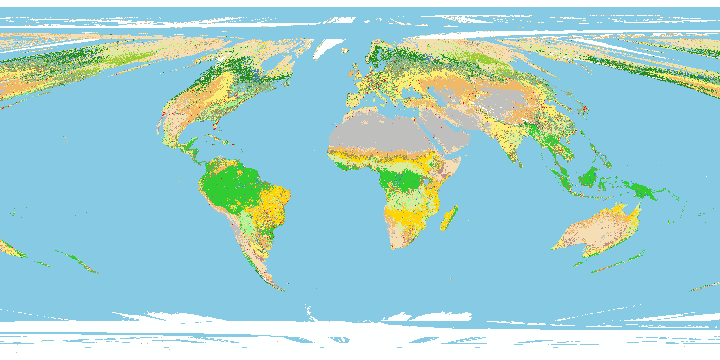
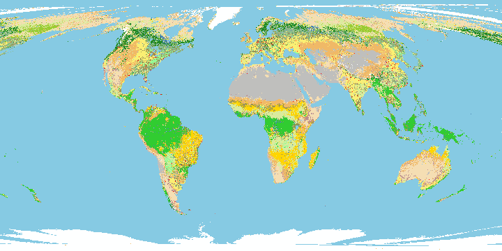
I have set up a MapServer WMS for several global scale spatial data. The original crs for these data is WGS84 (EPSG:4326). I got weird maps when I requested this WMS using projections like EPSG:54008 (World Sinusoidal) and EPSG:54009 (World Mollweide). Those maps created by this WMS looks like a mess in north pole and south pole areas, as shown in the attached screenshots. You can also test this WMS by clicking the two links below.
Request map from WMS using Sinusoidal projection: http://webmap.ornl.gov/ogcbroker/wms?LAYERS=10004_1&TRANSPARENT=true&FORMAT=image%2Fpng&BANDS=1&SERVICE=WMS&VERSION=1.1.1&REQUEST=GetMap&STYLES=&EXCEPTIONS=application%2Fvnd.ogc.se_inimage&SRS=EPSG%3A54008&bbox=-20015077.371192962%2C-10007538.685596481%2C20015077.371192962%2C10007538.685596481&width=720&height=360
Request map from WMS using Mollweide projection: http://webmap.ornl.gov/ogcbroker/wms?LAYERS=10004_1&TRANSPARENT=true&FORMAT=image%2Fpng&BANDS=1&SERVICE=WMS&VERSION=1.1.1&REQUEST=GetMap&STYLES=&EXCEPTIONS=application%2Fvnd.ogc.se_inimage&SRS=EPSG%3A54009&bbox=-18040095.696120452%2C-9020047.848060226%2C18040095.696120452%2C9020047.848060226&width=720&height=360
This problem happened for several versions of MapServer, including the current version (5.6.3)
Thank you.
Attachments (3)
Change History (5)
by , 14 years ago
| Attachment: | modis_sinusoidal.png added |
|---|
comment:1 by , 14 years ago
| Owner: | changed from to |
|---|---|
| Priority: | highest → high |
Yaxing Wei,
Can you provide the mapfile and supporting data for this? It appears that you are using vector source data, and some polygons are getting badly twisted near the pole but it is difficult to tell.
comment:2 by , 14 years ago
Hi,
I'm not using vector source data. It is a GeoTIFF raster data. Actually, this problem does not exist for vector data, as you can see from here: http://webmap.ornl.gov/cgi-bin/mapserv.exe?map=D:/CONFIG/MAPFILE/baselayers.map&LAYERS=world&TRANSPARENT=true&FORMAT=image%2Fpng&SERVICE=WMS&VERSION=1.1.1&REQUEST=GetMap&STYLES=&EXCEPTIONS=application%2Fvnd.ogc.se_inimage&SRS=EPSG%3A54008&BBOX=-20015077.371192,-10007538.685596,20015077.371192,10007538.685596&WIDTH=720&HEIGHT=360
The above map looks good. So this is only a problem for raster data.
Attached please find the mapfile for the GeoTIFF raster data with problems. Thank you.
by , 14 years ago
| Attachment: | 10004_1_wms_webmap.map added |
|---|
mapfile for the raster data with projection problem
map in sinusoidal projection