
Opened 17 years ago
Closed 17 years ago
#2121 closed enhancement (fixed)
gd-rendering : draw symbols along a line using pixmap symbols
| Reported by: | assefa | Owned by: | jmckenna |
|---|---|---|---|
| Priority: | normal | Milestone: | 5.0 release |
| Component: | Documentation - MapServer | Version: | |
| Severity: | normal | Keywords: | |
| Cc: | jmckenna@… |
Description
Currently for line features, when a pixmap symbol is set in a style, the pixmap is used as a brush to draw the line. If the true type fnts is used, it will draw the font along the line. The idea is to support the pixmap symbols to work like the true type fonts. Distnace bteween symbols would use the GAP parameter in the symbol. Symbols will be rotated and scale if necessary along the line.
Attachments (2)
Change History (19)
comment:1 by , 17 years ago
| Owner: | changed from to |
|---|---|
| Status: | new → assigned |
comment:2 by , 17 years ago
| Cc: | added |
|---|
comment:3 by , 17 years ago
doc http://mapserver.gis.umn.edu/docs/reference/symbology should be updated for the GAP parameter. The update should reflect
- that GAP is also used for pixmap symbols.
- The text about the negative GAP should be changed : a negative gap will add 180 degress to the angle. The true type and pixmap symbols are always oriented along the line
comment:4 by , 17 years ago
| Owner: | changed from to |
|---|---|
| Status: | assigned → new |
comment:5 by , 17 years ago
in previous versions, a negative GAP forced the direction of the symbol to follow the digitizing direction of the line. now, in 5.0, this seems not to work anymore. Negative GAP seems to have no effect at all to me.
comment:7 by , 17 years ago
falvio,
- Can you confirm that you are using a true type symbols and not a pixmap symbol ?
- From what I can see, the 5.0 image seems to be an AGG output so It would be an AGG specific bug. Looking into the source code, there is no change AFAIK done in the gd code concerning true type symbols drawn along the line. You could maybe quickly confirm that the GD rendering works in 5.0.
Looking into the AGG code, It seems to me that there might be a problem with true type symbols darwn along the line, but I do not have a good test data immaediatly available to test this. Please let me know and if it is the case, we could enter a bug in the AGG module and correct it.
comment:8 by , 17 years ago
hi assefa
I can confirm:
- truetype symbols
- no difference if I use AGG or not (i.e. simple JPEG)
- exactly the same data and same MapFile sections and Symbol Definitions (see below)
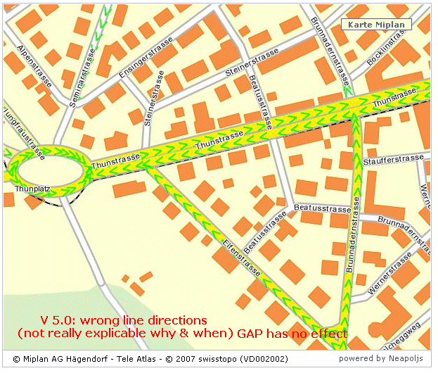
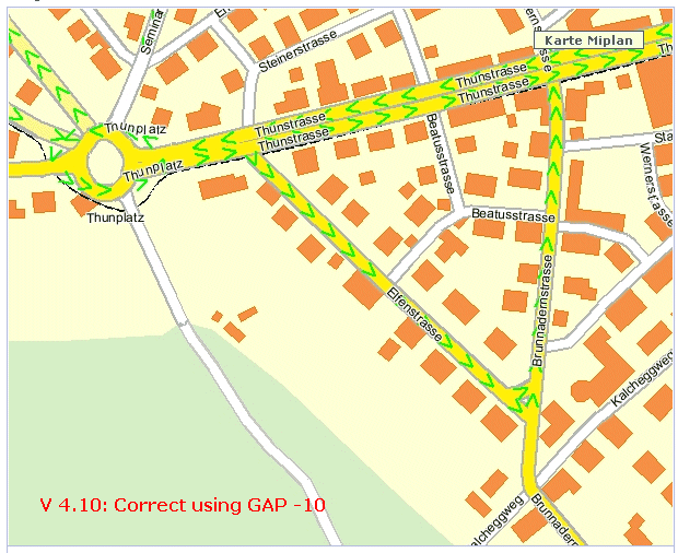
- seems that with 5.0 the negative GAP is completely ignored (the 5.0 result with negative GAP looks like 4.10 with no GAP or positive GAP).
SYMBOL
NAME "Arrow1" TYPE TRUETYPE FONT "Arial" CHARACTER ">" GAP -10
END
follow-up: 10 comment:9 by , 17 years ago
flavio this seems to have been fixed today: http://trac.osgeo.org/mapserver/changeset/6746
comment:10 by , 17 years ago
flavio this seems to have been fixed today: http://trac.osgeo.org/mapserver/changeset/6746
GAP Value does not work 100%. If I have a GAP of -10, -20, -1000, result is always the same ... This is the case when having SIZEUNITS meters. I'd expect the GAP to be meters then (?) ... SIZEUNITS pixels seems fine.
follow-up: 12 comment:11 by , 17 years ago
falvio,
I have not tried what you have reported but if it is a bug, It would be better to enter it as a new AGG bug (or send an e-mail on the list) and hopefully it will be adressed before the release. This discussion is reallly out of the bug 2121 and should be separted.
comment:12 by , 17 years ago
Hi Assefa
I did that already, to me it is not an AGG bug. It is a generic bug. SIZEUNITS are not used by the Symbol Definition. See Ticket #2289.
comment:13 by , 17 years ago
Can someone mark this one as fixed or wontfix if indeed the original subject of this bug is no longer an issue?
Steve
comment:14 by , 17 years ago
Steve, I left it open and assigned to to Jeff for the docs to be updated. I think when Jeff is done with the update, It will be closed.
comment:15 by , 17 years ago
| Component: | MapServer C Library → MapServer Documentation |
|---|
comment:16 by , 17 years ago
| Owner: | changed from to |
|---|---|
| Status: | new → assigned |
comment:17 by , 17 years ago
| Resolution: | → fixed |
|---|---|
| Status: | assigned → closed |
i have updated the GAP parameter for http://mapserver.gis.umn.edu/docs/reference/symbology and tested with mapserver-5.0-rc2.
Commited in r6205.
Needs to update related docs before closing.