
| Version 9 (modified by , 17 years ago) ( diff ) |
|---|
MapGuide RFC 26 - Stylize Grid Surface
This page contains an change request (RFC) for the MapGuide Open Source project. More MapGuide RFCs can be found on the RFCs page.
Status
| RFC Template Version | 1.0 |
| Submission Date | Aug 2, 2007 |
| Last Modified | Maggie Yang Timestamp |
| Author | Maggie Yang |
| RFC Status | draft |
| Implementation Status | under development |
| Proposed Milestone | 1.3 |
| Assigned PSC guide(s) | (when determined) |
| Voting History | (vote date) |
| +1 | |
| +0 | |
| -0 | |
| -1 |
Overview
This section brefly describes the problem set, and the proposed solution in general terms. It should be deliberately short, a couple of sentences or so.
Motivation
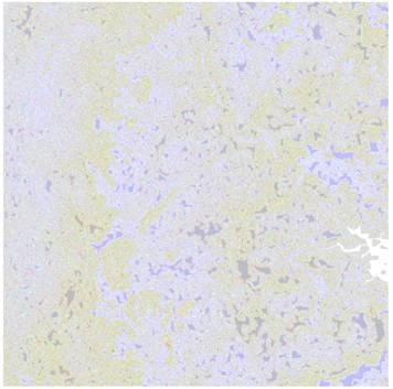
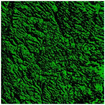
For elevation data, such as DEM file, which would not be displayed in MapGuide as it does in Map 3D, because the MapGuide do not have the stylization mechanism for grid surface data as Map does. So, in this release, we will make MapGuide has the ability to stylize the elevation layer. If publish a elevation layer from Map 3D to MapGuide, the user would see Figure 1 in MapGuide Studio in the future, not the Figure 2, which is the current status for elevation data in MapGuide.
 | instead of | 
|
| Figure1 | Figure2 |
Proposed Solution
This is a more detailed description of the actual changes desired. The contents of this section will vary based on the target of the RFC, be it a technical change, website change, or process change. For example, for a technical change, items such as files, XML schema changes, and API chances would be identified. For a process change, the new process would be laid out in detail. For a website change, the files affected would be listed.
Implications
This RFC does not describe any GUI modifications. The layer definition xml document was published from Map 3D. There are no changes to the existing public API.
Test Plan
Publish a Grid Surface data from Map 3D to MapGuide server, at the end the surface image should display as it was shown in Map 3D.
Funding/Resources
Supplied by Autodesk.
Attachments (2)
- Before.JPG (17.4 KB ) - added by 17 years ago.
- After.JPG (45.2 KB ) - added by 17 years ago.
Download all attachments as: .zip