
| Version 13 (modified by , 17 years ago) ( diff ) |
|---|
MapGuide RFC 26 - Stylize Elevation Layer
This page contains an change request (RFC) for the MapGuide Open Source project. More MapGuide RFCs can be found on the RFCs page.
Status
| RFC Template Version | 1.0 |
| Submission Date | Aug 2, 2007 |
| Last Modified | Maggie Yang Timestamp |
| Author | Maggie Yang |
| RFC Status | draft |
| Implementation Status | under development |
| Proposed Milestone | 1.3 |
| Assigned PSC guide(s) | (when determined) |
| Voting History | (vote date) |
| +1 | |
| +0 | |
| -0 | |
| -1 |
Overview
The purpose of this RFC is to allow MapGuide to stylize the elevation data, which configured surface style in its layer definition.
Motivation
MapGuide cannot stylize the elevation layer, such as DEM and GeoTIFF file, configured by the following kind of layer definition with surface style:
<LayerDefinition xmlns:xsi="http://www.w3.org/2001/XMLSchema-instance" xmlns:xsd="http://www.w3.org/2001/XMLSchema" xsi:noNamespaceSchemaLocation="LayerDefinition-1.0.0.xsd" version="1.0.0">
<GridLayerDefinition>  <ResourceId>Library://Publish/Data/Raster_1.FeatureSource</ResourceId>
  <FeatureName>rasters:davenport</FeatureName>
  <Geometry>Image</Geometry>
  <GridScaleRange>
    <SurfaceStyle>
      <Band>1</Band>
      <DefaultColor>0000FF00</DefaultColor>
    </SurfaceStyle>
    <ColorStyle>
      <HillShade>
        <Band>1</Band>
        <Azimuth>45</Azimuth>
        <Altitude>45</Altitude>
      </HillShade>
      <ColorRule>
        <LegendLabel>-1.79e+308 to 1.79e+308</LegendLabel>
        <Filter>(Height(1) > -1.7976931348623158e+308) AND (Height(1) < 1.7976931348623158e+308)</Filter>
        <Color>
          <ExplicitColor>FF00FF00</ExplicitColor>
        </Color>
      </ColorRule>
      <ColorRule>
        <LegendLabel>{DEFAULT}</LegendLabel>
        <Color>
          <ExplicitColor>FF006423</ExplicitColor>
        </Color>
      </ColorRule>
    </ColorStyle>
    <RebuildFactor>1</RebuildFactor>
  </GridScaleRange>
</GridLayerDefinition>
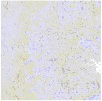
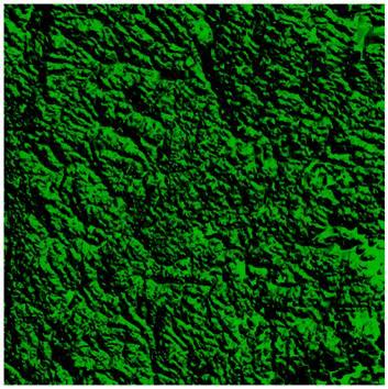
Currently, MapGuide do not have the stylization mechanism for grid surface data. So, in this release, we will make MapGuide has the ability to stylize the elevation layer. The user would see the stylized elevation data, like Figure 1 in MapGuide in the future, not the Figure 2, which is the current status for elevation data in MapGuide.
 | instead of | 
|
| Figure1 | Figure2 |
Proposed Solution
Modify Stylization project to support the stylization of the elevation data, with surface style. New classes will be introduced to handle that style information, such as color, band, surface, hillshade and etc.
Implications
This RFC does not describe any GUI modifications and does not affect the existed published API.
Test Plan
Add an elevation layer to MapGuide, the elevation layer should display with grid surface, like Figure1.
Funding/Resources
Supplied by Autodesk.
Attachments (2)
- Before.JPG (17.4 KB ) - added by 17 years ago.
- After.JPG (45.2 KB ) - added by 17 years ago.
Download all attachments as: .zip