
| Version 288 (modified by , 7 years ago) ( diff ) |
|---|
GRASS 7 Release Planning
Table of Contents
- Release scope: new display architecture, new raster library, new features such as temporal data handling...
- The SVN trunk corresponds to GRASS 7 (for access, see here)
- http://grass.osgeo.org/wiki/GRASS_7_ideas_collection (to be merged into trac)
Already implemented
- New features in version 7 (already implemented)
- 3D raster library and modules in version 7 (finished)
- Introduction of temporal modules | Available temporal modules | Tutorials (user contributed content)
Planning & ongoing
Source code changes:
- Display library in GRASS 7 (planning & ongoing)
- Raster library in GRASS 7 (planning & ongoing)
- Vector library in GRASS 7 (planning & ongoing)
- Temporal extension for GRASS 7 (core functions are implemented, ongoing improvement)
- Temporal Library API
- Temporal GIS Algebra for Raster and Vector Data GSoC project 2013
Documentation
- Use Sphinx for Python API (complete?)
- Documentation: update HTML manual pages to more recent technology (see examples by Vaclav Petras) and #151
Trunk
- NULL compression, make default
~and backport to 7.0 for compatibility~ - RLE/DEFLATE/LZ4 compression: #2750: LZ4 when writing raster rows; better than double I/O bound r.mapcalc speed
- r.mapcalc / r3.mapcalc: new variables to access current region dimensions in cells (nrows, ncols, ndepths) (r67664)
7.2.0 (to be backported)
- nothing left?
7.2.1 (to be backported)
- libproj: cleanup of local copies of NAD and datum shift files which are used from GDAL; extended documentation in README.txt (trac #2456): r69211
- libproj: Fix GPJget_datum_params() to respect r69211 (see #2456): r69494
- libgis: set valid ZLIB compression level: r69388
- lib/python/temporal: major differences
- parser: add standard option for 2D raster map type: r68867
- use cats title as primary, see #3035 (r68746, r68747, r68748, r69645)
- man pages: misc --> miscellaneous: r69585, r69587, r69588, r69589, r69709
- d.barscale: improve layout, use variables instead of magick numbers, add width_scale variable to scale barscale for different resolutions: r69619
- g.search.modules: flag to negate/invert selection: r69152
- g.search.modules: search for an exact keyword associated with a module using -k flag: r69155
- r.grow: +shrink (r69110)
- r.out.xyz: new -i flag to include no data values: r70017
- r.what: print labels also for FCELL/DCELL maps: r69356
- r.grow.distance: clean up after r68611: r69327
- r.in.lidar: Storage type
- r.in.xyz: unify keywords and method descriptions with r.in.lidar (r68596): r68600
- r.quantile: fix memory violations: r69774
- simlib: give more control over seeding of random number generator: r69620
- r.stats.quantile: fix memory violations, optimize for a large number of base categories: r69776
- r.texture fixes?
- v.in.ascii: add text=none to restore geonames import: r69354
- v.in.lidar: check for valid LAS reader as in r.in.lidar r68982
- vector modules: Added layer specific database information to v.info extended metadata flag: r69535
- v.out.postgis doesn't export attribute table (see #2460): r69672
- v.proj: add no topology flag: r69960
- v.vol.rst: improve wording of warning (#3100): r69439
- v.to.rast: fix category labels for use=attr: r69357
- v.to.rast: just leave the color table to be the default: r69326
- v.what.strds: add capabilities to use names also for temporal dataset with minutes and seconds granularity: r69331
- wxGUI/location wizard simplification: r69985
Blockers
No results
Critical issues
No results
handpicked issues:
- #2456: read CSV from GDAL data directory
Further issues
- Check overview in: https://trac.osgeo.org/grass/milestone/7.0.4
- Open bugs concerning GRASS 7
- List Open Enhancement Requests
General strategy
... regular publication of stability releases:
7.0.x ... 7.0.1 ... 7.0.0:
- all released, see Release
Historical notes
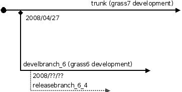
- a releasebranch_6_4 branch has been created (for access, see here) - used to release GRASS GIS 6.4.x
- a develbranch_6 branch has been created (for access, see here) - unused since 2015
- trunk has become GRASS 7.1.svn
- branches/releasebranch_7_0 has become GRASS 7.0.svn
- Announcement (2008, GRASS 7 development started)
- GRASS GIS 6.3.0 has been released from the releasebranch_6_3 branch
See also

Attachments (1)
-
Grass7-development-svn.png
(6.9 KB
) - added by 16 years ago.
GRASS 7 development SVN diagram
Download all attachments as: .zip
Note:
See TracWiki
for help on using the wiki.