| Version 13 (modified by , 14 years ago) ( diff ) |
|---|
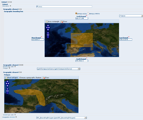
ISO19115 extent map editor and map viewer
| Date | 2009/08/03 |
| Contact(s) | Francois, Patrick valsecchi, Eric Lemoine |
| Last edited | Timestamp |
| Status | Motion passed |
| Assigned to release | 2.5.0 |
| Resources | Complete |
Overview
Add a GeoExt map panel in order to draw and display on a map the bounding box or bounding polygon of an ISO 19139/119 metadata record.
Proposal Type
- Type: GUI Change
- App: GeoNetwork
- Module: Editor
Links
- Documents:
- Email discussions:
- Other wiki discussions:
Voting History
- Vote proposed by Francois on http://n2.nabble.com/Proposal-new-ISO19139-119-metadata-extent-editor-viewer-td3472743.html#a3472743 result was +/-n (m non-voting members).
- +1 Francois
- +1 Jeroen
- +1 Simon
- +1 Andrea
- +1 Emmanuel
Motivations
The current configuration is based on:
- 4 input fields to define bounding box coordinates with a list of regions to quickly set up those 4 values.
- Bounding polygon could be define using GML object definition within the editor. But then user need to type coordinate of gmd:polygon elements manually.
The propsed change is to display a map in edit/view mode in order to be able to draw/display the metadata extent.

Proposal
Description
The map is in default WGS84 projection. In view mode:
- the map navigation is disabled
- the map zoom to the feature
- one map is displayed for each extent bounding polygon or bounding box.
In editing mode:
- a clear button allows to clear the feature on the map.
- navigation and mouse coordinate controls are available
- Bounding box
- a draw rectangle tool
- the list of region is available to quickly define a bounding box and the description if available.
- if more than one projection is defined in the configuration file, editor could display coordinates in another projection (does not change map projection, only form field content).
- Bounding polygon
- a draw polygon tool
- a draw circle tool
The config-gui.xml allows to define global parameters:
- map size
- list of projection (used to display bounding box coordinate in different projection.
Dependencies
New librairies are needed:
- OpenLayers
- ExtJS
- GeoExt
These libraries will be needed for Intermap to OpenLayers migration also. ExtJS could also be used instead of the modalBox lib.
jstools is used to minify and concatenate javascript files.
Known improvements
- Change map projection.
- Select feature from WFS (on going)
Backwards Compatibility Issues
Risks
Participants
- Francois
- Patrick
- Eric
- igrcic
Attachments (2)
- editor-geo-editing.png (167.9 KB ) - added by 15 years ago.
-
geoeditor.swf
(4.3 MB
) - added by 15 years ago.
Geographic extent editor and viewer screencast
Note:
See TracWiki
for help on using the wiki.