| Version 4 (modified by , 6 years ago) ( diff ) |
|---|
WCS Best Practices for Interoperability
This page is created for gathering best practices about how to use WCS so that it 1) is standard compliant 2) helps with achieving interoperability between different implementations.
Related mailing list threads:
https://lists.osgeo.org/pipermail/gdal-dev/2017-April/046366.html
https://lists.osgeo.org/pipermail/gdal-dev/2017-November/047650.html
Test data
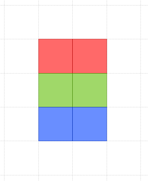
Sample image A from the WCS KISS dataset

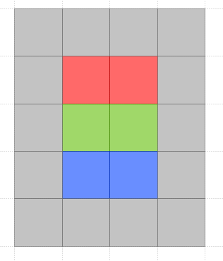
Sample image B from the WCS KISS dataset

Image A is an exact SUBSET of image B
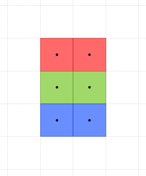
Images are of type "pixel is area". The pixel centers show in this image
![]()
Extents of the test images
1) In first case the raster images are somewhere in Chine where the longitude is greater than 90. Polygons which contain completely all the pixels are in the PostGIS EWKT format:
Image A: SRID:4326;POLYGON (( 115 30, 115 33, 117 33, 117 30, 115 30 ))
Image B: SRID:4326;POLYGON (( 114 29, 114 34, 118 34, 118 29, 114 29 ))
Image A has width=2 and height=3 and it can be constructed from an array: [Red,Red,Green,Green,Blue,Blue]
Image B has width=4 and height=5 and can be constructed from an array: [Grey,Grey,Grey,Grey,Grey,Red,Red,Grey,Grey,Green,Green,Grey,Grey,Blue,Blue,Grey,Grey,Grey,Grey,Grey]
Attachments (8)
-
WCS_KISS_Image_B.png
(3.4 KB
) - added by 6 years ago.
WCS KISS test image B
-
WCS_KISS_Image_A.png
(2.8 KB
) - added by 6 years ago.
WCS KISS test image A
-
WCS_KISS_Image_A_with_pixel_centers.png
(3.3 KB
) - added by 6 years ago.
WCS KISS test image A with pixel centers
-
WCS_KISS_A.tif
(396 bytes
) - added by 6 years ago.
WCS_KISS_A image as GeoTIFF
-
geoserver-DescribeCoverage_WCS_KISS_A.xml
(3.5 KB
) - added by 6 years ago.
DescribeCoverage for the KISS A image from GeoServer 2.11 with WCS 2.0.1
-
WCS_KISS_B.tif
(438 bytes
) - added by 6 years ago.
4 by 5 pixel test image WCS_KISS_B as GeoTIFF
-
create_kiss_a.py
(1.6 KB
) - added by 6 years ago.
Python script that creates WCS_KISS_A.tif
-
create_kiss_b.py
(1.6 KB
) - added by 6 years ago.
Python script that creates WCS_KISS_B.tif
Download all attachments as: .zip