| Version 1 (modified by , 6 years ago) ( diff ) |
|---|
WCS Best Practices for Interoperability
This page is created for gathering best practices about how to use WCS so that it 1) is standard compliant 2) helps with achieving interoperability between different implementations.
Related mailing list threads:
https://lists.osgeo.org/pipermail/gdal-dev/2017-April/046366.html https://lists.osgeo.org/pipermail/gdal-dev/2017-November/047650.html
Attachments (8)
-
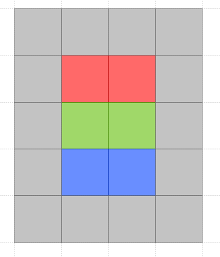
WCS_KISS_Image_B.png
(3.4 KB
) - added by 6 years ago.
WCS KISS test image B
-
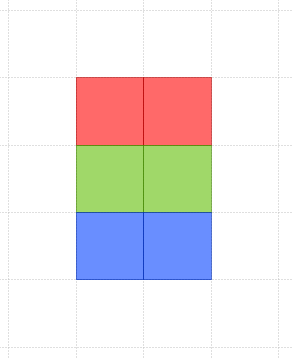
WCS_KISS_Image_A.png
(2.8 KB
) - added by 6 years ago.
WCS KISS test image A
-
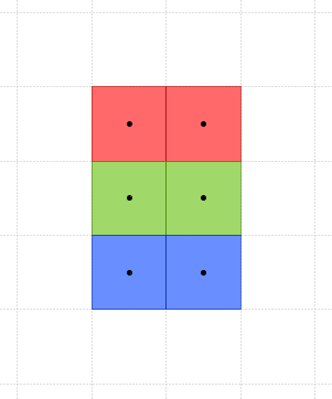
WCS_KISS_Image_A_with_pixel_centers.png
(3.3 KB
) - added by 6 years ago.
WCS KISS test image A with pixel centers
-
WCS_KISS_A.tif
(396 bytes
) - added by 6 years ago.
WCS_KISS_A image as GeoTIFF
-
geoserver-DescribeCoverage_WCS_KISS_A.xml
(3.5 KB
) - added by 6 years ago.
DescribeCoverage for the KISS A image from GeoServer 2.11 with WCS 2.0.1
-
WCS_KISS_B.tif
(438 bytes
) - added by 6 years ago.
4 by 5 pixel test image WCS_KISS_B as GeoTIFF
-
create_kiss_a.py
(1.6 KB
) - added by 6 years ago.
Python script that creates WCS_KISS_A.tif
-
create_kiss_b.py
(1.6 KB
) - added by 6 years ago.
Python script that creates WCS_KISS_B.tif
Download all attachments as: .zip
Note:
See TracWiki
for help on using the wiki.