Opened 12 years ago
Closed 9 years ago
#4851 closed defect (worksforme)
gdalwarp reprojection (NAD83 to NAD83 UTM) and format conversion (USGSDEM to ERS) issue
| Reported by: | tcgeophysics | Owned by: | warmerdam |
|---|---|---|---|
| Priority: | normal | Milestone: | |
| Component: | GDAL_Raster | Version: | 1.9.0 |
| Severity: | normal | Keywords: | gdalwarp UTM ERS reprojection EPSG issue |
| Cc: |
Description
Hi,
gdalwarp failed in converting the format and reprojecting a .dem file.
I want to convert a file format from USGSDEM to ERS, and reproject using epsg codes from NAD83 (4269) to NAD83 UTM Z10 (26910)
The input file is a Canadian Digital Elevation Data (CDED) DEM. When retrieving the file it comes as two tiles (east and west) from a NTS mapsheet (092H07 in this case).
The command i want to use is the following:
gdalwarp -s_srs EPSG:4269 -t_srs EPSG:26910 -of ERS 092h07_0100_deme.dem 092h07_UTM10_deme_TC.ers
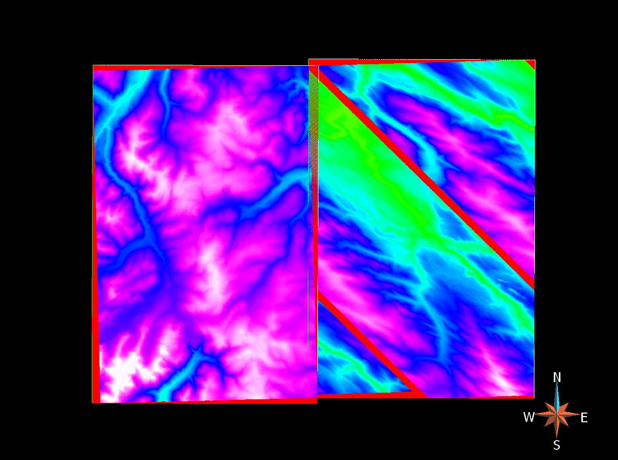
The west tile comes out great but the east tile seems to have an issue with the writing of the elevation data in the band (See CDED_reprojectionbug.jpg).
A workaround was found by first reprojecting from NAD83 to NAD83 UTM Z11 and then to NAD83 Z10 to have a good result.
Who has an idea why the direct reprojection does not work properly? Could it be due to the fact the raster is located at the limit of two UTM zones?
Attachments (1)
Change History (8)
by , 12 years ago
| Attachment: | CDED_reprojectionbug.jpg added |
|---|
follow-up: 2 comment:1 by , 12 years ago
Hi, can you point me to where I can get the 092h07_0100_deme.dem file?
comment:2 by , 12 years ago
Replying to warmerdam:
Hi warmerdam,
I tried to attached the file but it was too big... Here is a link to the geobase website where you can download the CDED tile 092h07:
http://www.geobase.ca/geobase/en/browse.do?produit=cded&decoupage=50k&map=092H
Hi, can you point me to where I can get the 092h07_0100_deme.dem file?
follow-up: 5 comment:3 by , 12 years ago
I am not seeing the problem you encounter when I use GDAL trunk or GDAL 1.9.2 and use OpenEV as my .ers viewer.
It is not clear to me whether you are encountering a bug that has been fixed since 1.9.0 or your viewer has some sort of problem with GDAL created .ers files.
comment:4 by , 12 years ago
| Component: | default → GDAL_Raster |
|---|
comment:5 by , 12 years ago
Replying to warmerdam:
The GDAL version could be the source of the problem. I tested different other packages QGIS 1.8.0, VTBuilder 1.1 and experienced issue as well...
I upgraded GDAL to 1.9.1-2, checked the process again and there is still the same issue with the file. But it really looks like a format writing issue.
I am not seeing the problem you encounter when I use GDAL trunk or GDAL 1.9.2 and use OpenEV as my .ers viewer.
It is not clear to me whether you are encountering a bug that has been fixed since 1.9.0 or your viewer has some sort of problem with GDAL created .ers files.
comment:6 by , 12 years ago
I don't replicate the issue with GDAL 1.9.0, 1.9.2 or trunk, and viewers QGIS 1.8.0 or GlobalMapper 13.
comment:7 by , 9 years ago
| Resolution: | → worksforme |
|---|---|
| Status: | new → closed |
Closing as "works for me" which actually means that it worked for Even and Frank two years ago and tcgeophysics has not sent feedback since then. The image was still there in the download service but I did not bother to create an user account for myself for repeating the test.
Screenshot of issue